Ware Shoals West Topo Map South Carolina
To zoom in, hover over the map of Ware Shoals West
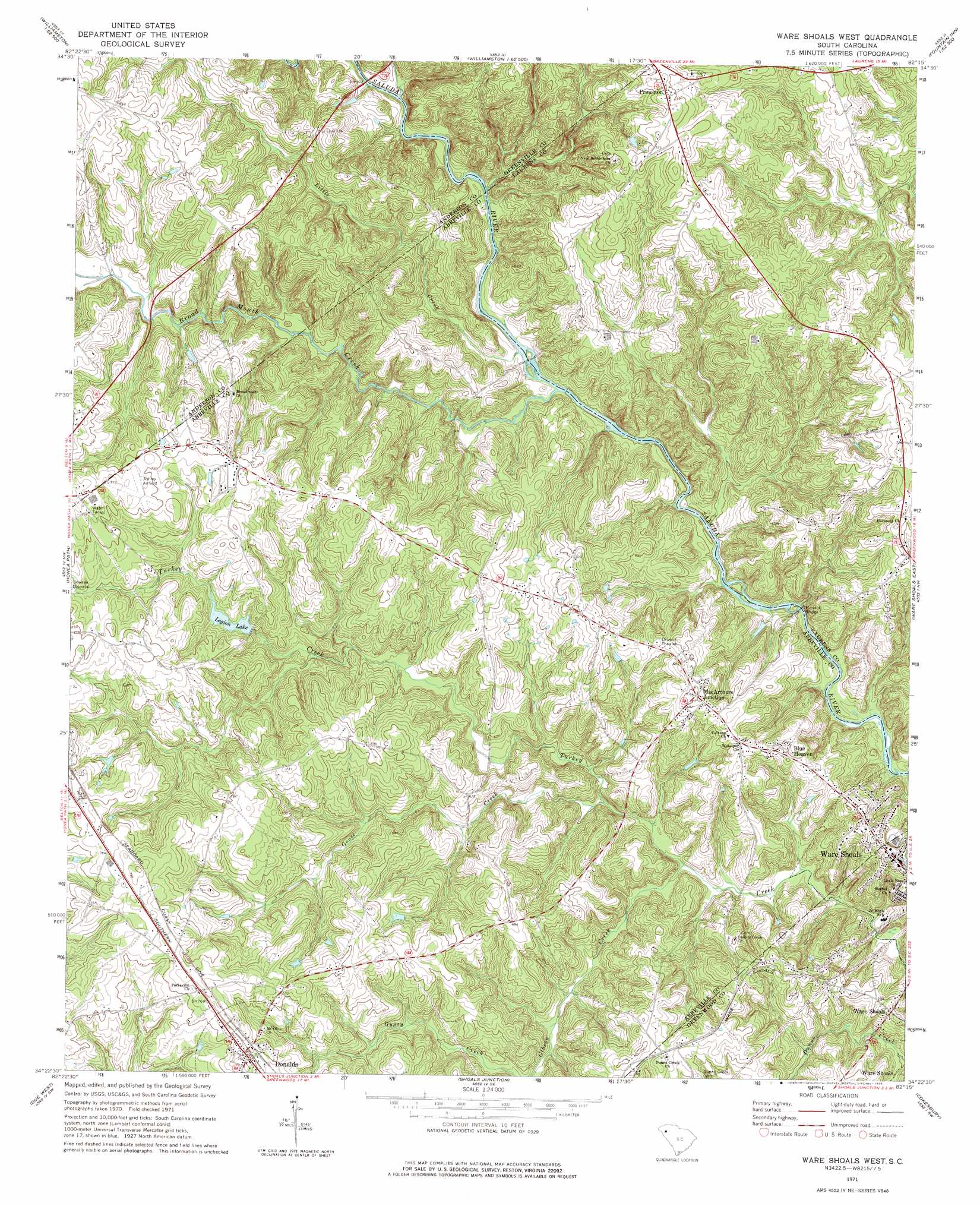
USGS Topo Quad 34082d3 - 1:24,000 scale
| Topo Map Name: | Ware Shoals West |
| USGS Topo Quad ID: | 34082d3 |
| Print Size: | ca. 21 1/4" wide x 27" high |
| Southeast Coordinates: | 34.375° N latitude / 82.25° W longitude |
| Map Center Coordinates: | 34.4375° N latitude / 82.3125° W longitude |
| U.S. State: | SC |
| Filename: | o34082d3.jpg |
| Download Map JPG Image: | Ware Shoals West topo map 1:24,000 scale |
| Map Type: | Topographic |
| Topo Series: | 7.5´ |
| Map Scale: | 1:24,000 |
| Source of Map Images: | United States Geological Survey (USGS) |
| Alternate Map Versions: |
Ware Shoals West SC 1971, updated 1975 Download PDF Buy paper map Ware Shoals West SC 2011 Download PDF Buy paper map Ware Shoals West SC 2014 Download PDF Buy paper map |
1:24,000 Topo Quads surrounding Ware Shoals West
Piercetown |
Pelzer |
Simpsonville |
Fountain Inn |
Woodruff |
Belton West |
Belton East |
Fork Shoals |
Hickory Tavern |
Laurens North |
Saylors Crossroads |
Honea Path |
Ware Shoals West |
Ware Shoals East |
Laurens South |
Antreville |
Due West |
Shoals Junction |
Cokesbury |
Waterloo |
Latimer |
Abbeville West |
Abbeville East |
Greenwood |
Ninety Six |
> Back to 34082a1 at 1:100,000 scale
> Back to 34082a1 at 1:250,000 scale
> Back to U.S. Topo Maps home
Ware Shoals West topo map: Gazetteer
Ware Shoals West: Bridges
Irwin Bridge elevation 170m 557′Kay Bridge elevation 172m 564′
Maddox Bridge elevation 160m 524′
Ware Shoals West: Crossings
Kinmans Ferry (historical) elevation 170m 557′Rutledge Ford elevation 168m 551′
Ware Shoals West: Dams
Pelletts Pond Dam D-3019 elevation 200m 656′South Carolina Noname 01002 D-0914 Dam elevation 200m 656′
Ware Shoals West: Populated Places
Blue Heaven elevation 196m 643′Broadmouth elevation 227m 744′
Dann (historical) elevation 239m 784′
Donalds elevation 232m 761′
Erie (historical) elevation 222m 728′
Foxville Crossroads elevation 232m 761′
MacArthurs Junction elevation 214m 702′
Murray (historical) elevation 228m 748′
Princeton elevation 232m 761′
Vermillion elevation 223m 731′
Ware Shoals West: Rapids
Dear Shoals elevation 163m 534′Johnson Shoals elevation 167m 547′
Maddox Shoals elevation 163m 534′
Narrow Shoal elevation 174m 570′
Rutledge Shoals elevation 169m 554′
Ware Shoals West: Reservoirs
American Legion Lake elevation 200m 656′Legion Lake elevation 200m 656′
Pelletts Pond elevation 190m 623′
Ware Shoals West: Streams
Broad Mouth Creek elevation 169m 554′Gibson Creek elevation 160m 524′
Goose Creek elevation 169m 554′
Line Creek elevation 174m 570′
Little Creek elevation 170m 557′
Mountain Creek elevation 173m 567′
Murray Creek elevation 181m 593′
Ware Shoals West digital topo map on disk
Buy this Ware Shoals West topo map showing relief, roads, GPS coordinates and other geographical features, as a high-resolution digital map file on DVD:
South Carolina, Western North Carolina & Northeastern Georgia
Buy digital topo maps: South Carolina, Western North Carolina & Northeastern Georgia