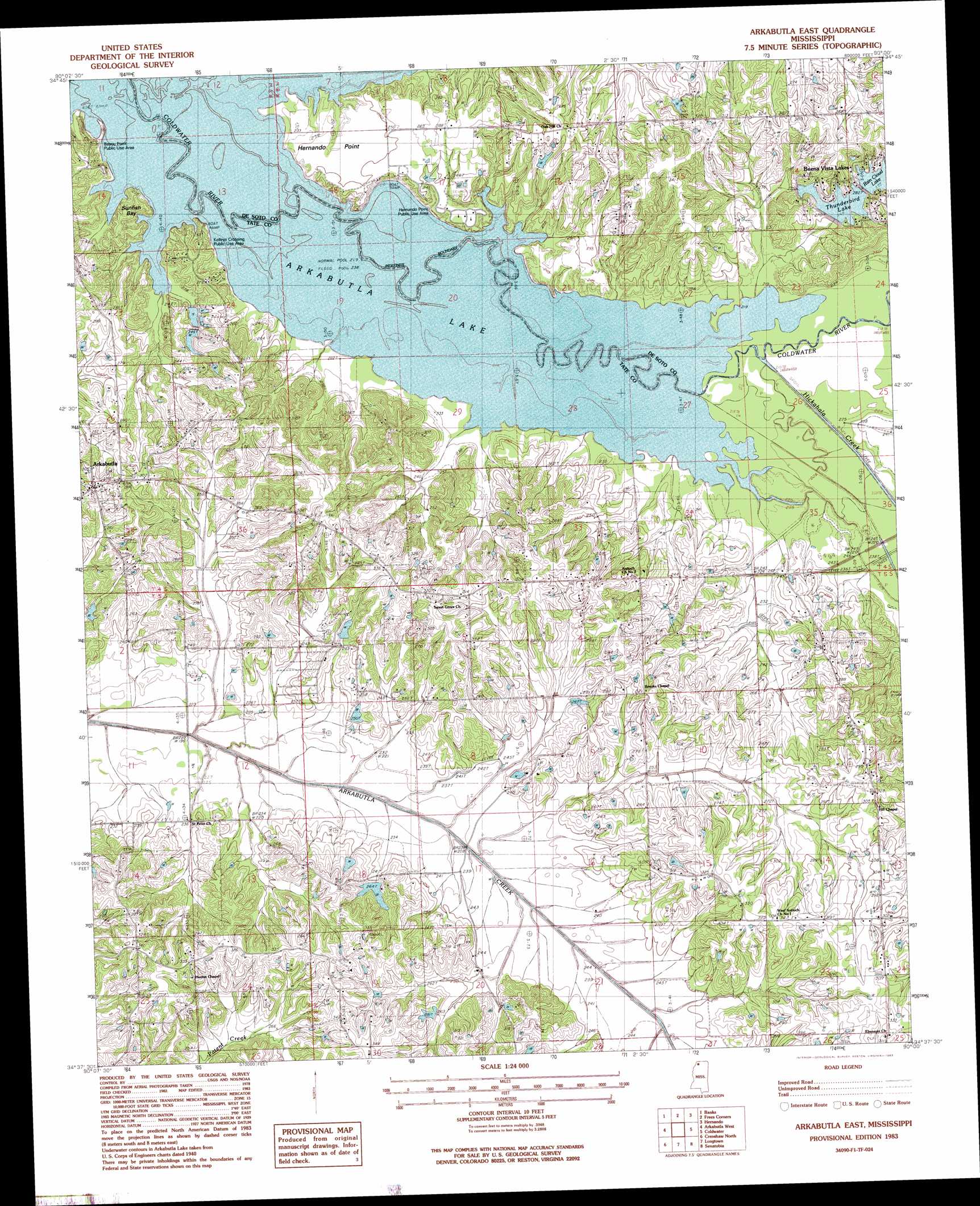
Arkabutla East Topo Map Mississippi
To zoom in, hover over the map of Arkabutla East
USGS Topo Quad 34090f1 - 1:24,000 scale
| Topo Map Name: | Arkabutla East |
| USGS Topo Quad ID: | 34090f1 |
| Print Size: | ca. 21 1/4" wide x 27" high |
| Southeast Coordinates: | 34.625° N latitude / 90° W longitude |
| Map Center Coordinates: | 34.6875° N latitude / 90.0625° W longitude |
| U.S. State: | MS |
| Filename: | o34090f1.jpg |
| Download Map JPG Image: | Arkabutla East topo map 1:24,000 scale |
| Map Type: | Topographic |
| Topo Series: | 7.5´ |
| Map Scale: | 1:24,000 |
| Source of Map Images: | United States Geological Survey (USGS) |
| Alternate Map Versions: |
Arkabutla East MS 1983, updated 1983 Download PDF Buy paper map Arkabutla East MS 2012 Download PDF Buy paper map Arkabutla East MS 2015 Download PDF Buy paper map |
1:24,000 Topo Quads surrounding Arkabutla East
Horseshoe Lake |
Lake Cormorant |
Horn Lake |
Pleasant Hill |
Olive Branch |
Robinsonville |
Banks |
Frees Corners |
Hernando |
Lewisburg |
Hollywood |
Arkabutla West |
Arkabutla East |
Coldwater |
Independence |
Walnut Lake |
Crenshaw North |
Longtown |
Senatobia |
Looxahoma |
Falcon |
Crenshaw South |
Pleasant Grove |
Sardis |
Sardis Dam |
> Back to 34090e1 at 1:100,000 scale
> Back to 34090a1 at 1:250,000 scale
> Back to U.S. Topo Maps home
Arkabutla East topo map: Gazetteer
Arkabutla East: Bays
Sunfish Bay elevation 66m 216′Arkabutla East: Capes
Bayou Point elevation 66m 216′Hernando Point elevation 76m 249′
Arkabutla East: Dams
Buena Vista Lakes Dam elevation 83m 272′Buena Vista Lakes Dam elevation 74m 242′
Doctor J Cash King Lake Dam elevation 66m 216′
Haas-Rush Lake Dam elevation 66m 216′
Hidden Valley Incorporated Lake Dam elevation 82m 269′
Hidden Valley Incorporated Lake Dam elevation 86m 282′
W P Veazey Junior Pond Dam elevation 79m 259′
W P Veazey Junior Pond Dam elevation 69m 226′
Arkabutla East: Parks
Bayou Point Public Use Area elevation 66m 216′Hernando Point Public Use Area elevation 74m 242′
Kelleys Crossing Public Use Area elevation 77m 252′
Sunfish Bay Public Use Area elevation 67m 219′
Arkabutla East: Populated Places
Arkabutla elevation 95m 311′Buena Vista Lakes elevation 94m 308′
Eliphaz elevation 72m 236′
Kelleys Crossing elevation 75m 246′
Arkabutla East: Reservoirs
Rain Cloud Lake elevation 85m 278′Thunderbird Lake elevation 81m 265′
Arkabutla East: Streams
Hickahala Creek elevation 66m 216′Arkabutla East digital topo map on disk
Buy this Arkabutla East topo map showing relief, roads, GPS coordinates and other geographical features, as a high-resolution digital map file on DVD: