Lewisburg Topo Map Mississippi
To zoom in, hover over the map of Lewisburg
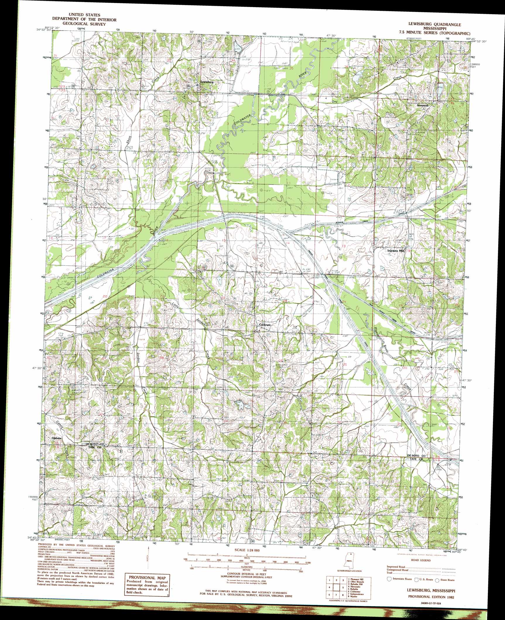
USGS Topo Quad 34089g7 - 1:24,000 scale
| Topo Map Name: | Lewisburg |
| USGS Topo Quad ID: | 34089g7 |
| Print Size: | ca. 21 1/4" wide x 27" high |
| Southeast Coordinates: | 34.75° N latitude / 89.75° W longitude |
| Map Center Coordinates: | 34.8125° N latitude / 89.8125° W longitude |
| U.S. State: | MS |
| Filename: | o34089g7.jpg |
| Download Map JPG Image: | Lewisburg topo map 1:24,000 scale |
| Map Type: | Topographic |
| Topo Series: | 7.5´ |
| Map Scale: | 1:24,000 |
| Source of Map Images: | United States Geological Survey (USGS) |
| Alternate Map Versions: |
Lewisburg MS 1982, updated 1983 Download PDF Buy paper map Lewisburg MS 2012 Download PDF Buy paper map Lewisburg MS 2015 Download PDF Buy paper map |
1:24,000 Topo Quads surrounding Lewisburg
Southwest Memphis |
Southeast Memphis |
Germantown |
Collierville |
Rossville |
Horn Lake |
Pleasant Hill |
Olive Branch |
Byhalia Nw |
Mount Pleasant |
Frees Corners |
Hernando |
Lewisburg |
Byhalia |
Red Banks |
Arkabutla East |
Coldwater |
Independence |
Wyatte |
Marianna |
Longtown |
Senatobia |
Looxahoma |
Tyro |
Laws Hill |
> Back to 34089e1 at 1:100,000 scale
> Back to 34088a1 at 1:250,000 scale
> Back to U.S. Topo Maps home
Lewisburg topo map: Gazetteer
Lewisburg: Bridges
Hollaway Bridge elevation 83m 272′Lewisburg: Canals
Byhalia Creek Canal elevation 84m 275′Lewisburg: Dams
C C Herrington Lake Dam elevation 99m 324′Charles Long Pond Dam elevation 84m 275′
J L Eason Junior Pond Dam elevation 100m 328′
M F Harris Pond Dam elevation 104m 341′
Lewisburg: Populated Places
Alphaba elevation 95m 311′Cockrum elevation 104m 341′
Ingrams Mill elevation 91m 298′
Lewisburg elevation 116m 380′
Stonewall elevation 115m 377′
Lewisburg: Streams
Byhalia Creek elevation 79m 259′Dry Creek elevation 80m 262′
Jordan Creek elevation 76m 249′
Little Jordan Creek elevation 77m 252′
Pigeon Roost Creek elevation 78m 255′
Red Banks Creek elevation 82m 269′
Short Branch elevation 75m 246′
Lewisburg digital topo map on disk
Buy this Lewisburg topo map showing relief, roads, GPS coordinates and other geographical features, as a high-resolution digital map file on DVD: