Nimrod Dam Topo Map Arkansas
To zoom in, hover over the map of Nimrod Dam
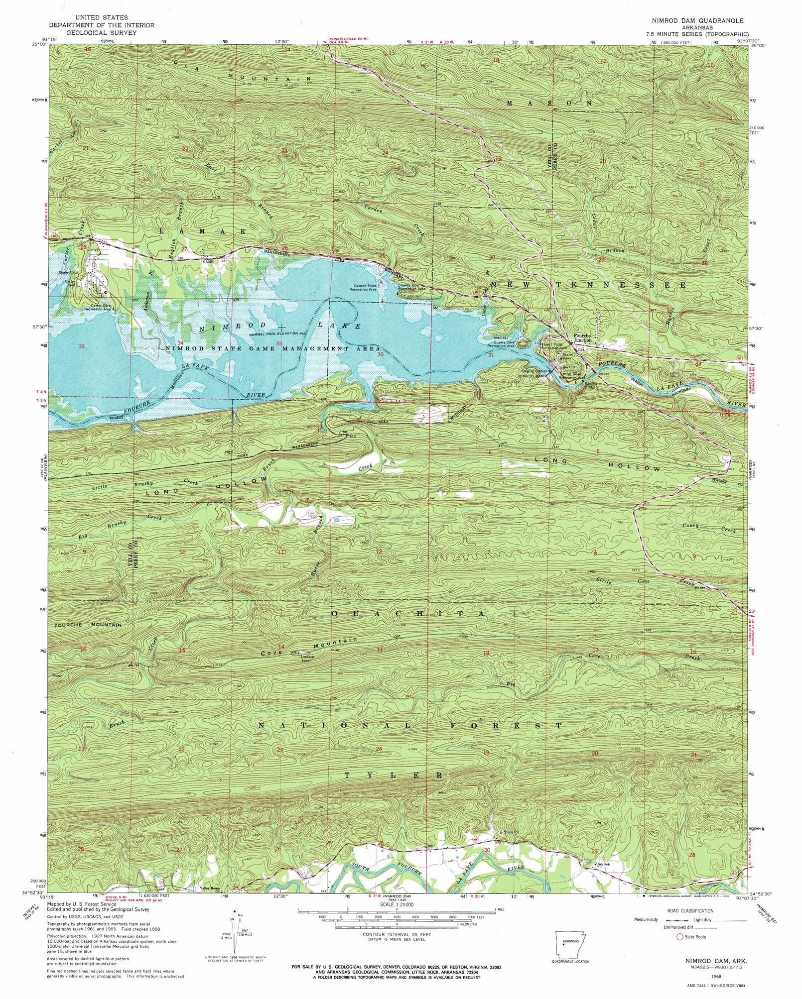
USGS Topo Quad 34093h2 - 1:24,000 scale
| Topo Map Name: | Nimrod Dam |
| USGS Topo Quad ID: | 34093h2 |
| Print Size: | ca. 21 1/4" wide x 27" high |
| Southeast Coordinates: | 34.875° N latitude / 93.125° W longitude |
| Map Center Coordinates: | 34.9375° N latitude / 93.1875° W longitude |
| U.S. State: | AR |
| Filename: | o34093h2.jpg |
| Download Map JPG Image: | Nimrod Dam topo map 1:24,000 scale |
| Map Type: | Topographic |
| Topo Series: | 7.5´ |
| Map Scale: | 1:24,000 |
| Source of Map Images: | United States Geological Survey (USGS) |
| Alternate Map Versions: |
Nimrod Dam AR 1968, updated 1970 Download PDF Buy paper map Nimrod Dam AR 2011 Download PDF Buy paper map Nimrod Dam AR 2014 Download PDF Buy paper map |
| FStopo: | US Forest Service topo Nimrod Dam is available: Download FStopo PDF Download FStopo TIF |
1:24,000 Topo Quads surrounding Nimrod Dam
Chickalah Mountain West |
Chickalah Mountain East |
Dardanelle |
Holla Bend |
Atkins |
Danville |
Danville Mountain |
Ola |
Casa |
Adona |
Rover |
Plainview |
Nimrod Dam |
Nimrod |
Aplin |
Onyx |
Steve |
Nimrod Sw |
Nimrod Se |
Paron Sw |
Fannie |
Avant |
Hamilton |
Jessieville |
Goosepond Moutain |
> Back to 34093e1 at 1:100,000 scale
> Back to 34092a1 at 1:250,000 scale
> Back to U.S. Topo Maps home
Nimrod Dam topo map: Gazetteer
Nimrod Dam: Crossings
Bales Ford (historical) elevation 103m 337′Nimrod Dam: Dams
Nimrod Dam elevation 97m 318′Nimrod Dam: Gaps
The Narrows elevation 92m 301′Nimrod Dam: Parks
Carden Point Public Use Area elevation 108m 354′Carter Cove Public Use Area elevation 114m 374′
County Line Recreation Area elevation 107m 351′
Nimrod State Game Management Area elevation 102m 334′
Project Point Recreation Area elevation 115m 377′
Quarry Cove Recreation Area elevation 109m 357′
River Road Recreation Area elevation 96m 314′
Nimrod Dam: Populated Places
Fourche Junction elevation 131m 429′Nimrod Dam: Reservoirs
Nimrod Lake elevation 97m 318′Nimrod Dam: Ridges
Ola Mountain elevation 389m 1276′Nimrod Dam: Streams
Anderson Branch elevation 104m 341′Big Brushy Creek elevation 161m 528′
Brush Creek elevation 105m 344′
Carden Creek elevation 108m 354′
Carter Creek elevation 109m 357′
Cedar Branch elevation 133m 436′
Cedar Gap Branch elevation 103m 337′
Dry Fork elevation 162m 531′
Earl Branch elevation 104m 341′
English Branch elevation 105m 344′
Guest Branch elevation 139m 456′
Little Brushy Creek elevation 147m 482′
Nimrod Dam: Summits
Chinquapin Mountain elevation 241m 790′Cove Mountain elevation 368m 1207′
Nimrod Dam digital topo map on disk
Buy this Nimrod Dam topo map showing relief, roads, GPS coordinates and other geographical features, as a high-resolution digital map file on DVD: