Fort Sumner East Topo Map New Mexico
To zoom in, hover over the map of Fort Sumner East
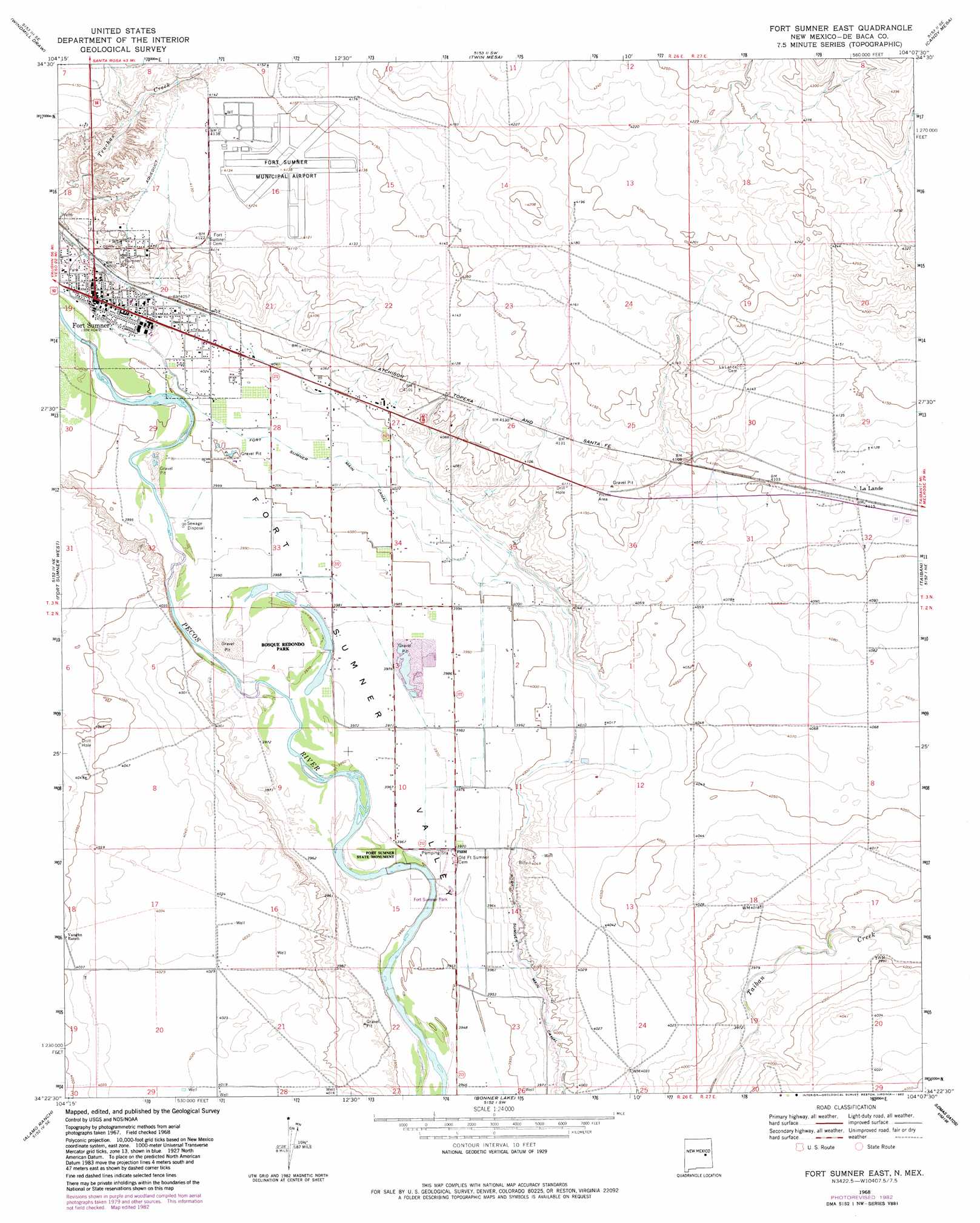
USGS Topo Quad 34104d2 - 1:24,000 scale
| Topo Map Name: | Fort Sumner East |
| USGS Topo Quad ID: | 34104d2 |
| Print Size: | ca. 21 1/4" wide x 27" high |
| Southeast Coordinates: | 34.375° N latitude / 104.125° W longitude |
| Map Center Coordinates: | 34.4375° N latitude / 104.1875° W longitude |
| U.S. State: | NM |
| Filename: | o34104d2.jpg |
| Download Map JPG Image: | Fort Sumner East topo map 1:24,000 scale |
| Map Type: | Topographic |
| Topo Series: | 7.5´ |
| Map Scale: | 1:24,000 |
| Source of Map Images: | United States Geological Survey (USGS) |
| Alternate Map Versions: |
Fort Sumner East NM 1968, updated 1971 Download PDF Buy paper map Fort Sumner East NM 1968, updated 1982 Download PDF Buy paper map Fort Sumner East NM 2010 Download PDF Buy paper map Fort Sumner East NM 2013 Download PDF Buy paper map Fort Sumner East NM 2017 Download PDF Buy paper map |
1:24,000 Topo Quads surrounding Fort Sumner East
Gibbons Ranch |
Colorado Canyon |
Twin Mesa Nw |
Hassell |
House |
Alamogordo Dam |
Windmill Draw |
Twin Mesa |
Candy Mesa |
Peach Canyon |
Ricardo |
Fort Sumner West |
Fort Sumner East |
Taiban |
Tolar |
West Camp |
Alamo Ranch |
Bonner Lake |
Lomas Gatos |
Tolar Sw |
Conejo Creek West |
Conejo Creek East |
Eighteenmile Hill |
Watts Hill |
Gammil Well |
> Back to 34104a1 at 1:100,000 scale
> Back to 34104a1 at 1:250,000 scale
> Back to U.S. Topo Maps home
Fort Sumner East topo map: Gazetteer
Fort Sumner East: Airports
Fort Sumner Municipal Airport elevation 1259m 4130′Fort Sumner East: Canals
Fort Sumner Main Canal elevation 1224m 4015′Fort Sumner East: Mines
Fort Sumner Pit elevation 1216m 3989′Fort Sumner East: Parks
Early Spanish Route Historical Marker elevation 1229m 4032′Fort Sumner Historical Marker elevation 1229m 4032′
Fort Sumner State Monument elevation 1205m 3953′
Fort Sumner State Monument Historical Marker elevation 1229m 4032′
Fort Sumner East: Populated Places
Fort Sumner elevation 1229m 4032′La Lande elevation 1255m 4117′
Fort Sumner East: Post Offices
Fort Sumner Post Office elevation 1229m 4032′La Lande Post Office (historical) elevation 1255m 4117′
Fort Sumner East: Springs
Sunnyside Springs elevation 1248m 4094′Fort Sumner East digital topo map on disk
Buy this Fort Sumner East topo map showing relief, roads, GPS coordinates and other geographical features, as a high-resolution digital map file on DVD: