Candy Mesa Topo Map New Mexico
To zoom in, hover over the map of Candy Mesa
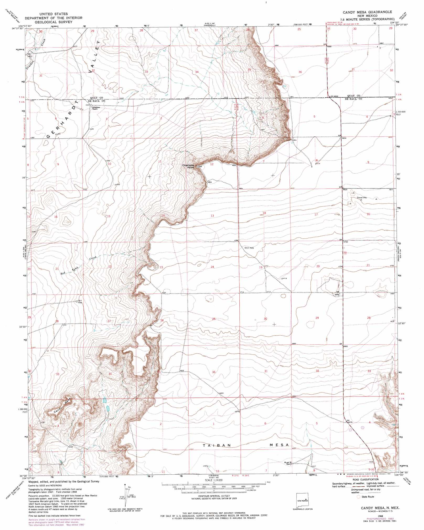
USGS Topo Quad 34104e1 - 1:24,000 scale
| Topo Map Name: | Candy Mesa |
| USGS Topo Quad ID: | 34104e1 |
| Print Size: | ca. 21 1/4" wide x 27" high |
| Southeast Coordinates: | 34.5° N latitude / 104° W longitude |
| Map Center Coordinates: | 34.5625° N latitude / 104.0625° W longitude |
| U.S. State: | NM |
| Filename: | o34104e1.jpg |
| Download Map JPG Image: | Candy Mesa topo map 1:24,000 scale |
| Map Type: | Topographic |
| Topo Series: | 7.5´ |
| Map Scale: | 1:24,000 |
| Source of Map Images: | United States Geological Survey (USGS) |
| Alternate Map Versions: |
Candy Mesa NM 1968, updated 1971 Download PDF Buy paper map Candy Mesa NM 1968, updated 1982 Download PDF Buy paper map Candy Mesa NM 2010 Download PDF Buy paper map Candy Mesa NM 2013 Download PDF Buy paper map Candy Mesa NM 2017 Download PDF Buy paper map |
1:24,000 Topo Quads surrounding Candy Mesa
Canada Colorado |
Ima Sw |
Ima Se |
Cunavea Basin |
Jordan |
Colorado Canyon |
Twin Mesa Nw |
Hassell |
House |
Mcalister |
Windmill Draw |
Twin Mesa |
Candy Mesa |
Peach Canyon |
House Se |
Fort Sumner West |
Fort Sumner East |
Taiban |
Tolar |
Krider |
Alamo Ranch |
Bonner Lake |
Lomas Gatos |
Tolar Sw |
Tolar Se |
> Back to 34104e1 at 1:100,000 scale
> Back to 34104a1 at 1:250,000 scale
> Back to U.S. Topo Maps home
Candy Mesa topo map: Gazetteer
Candy Mesa: Benches
Taiban Mesa elevation 1387m 4550′Candy Mesa: Cliffs
Charlotte Point elevation 1489m 4885′Candy Mesa: Streams
Red Tank Creek elevation 1346m 4416′Candy Mesa: Summits
Candy Mesa elevation 1388m 4553′Candy Mesa: Wells
10219 Water Well elevation 1344m 4409′10220 Water Well elevation 1374m 4507′
10241 Water Well elevation 1484m 4868′
10314 Water Well elevation 1424m 4671′
10318 Water Well elevation 1407m 4616′
10319 Water Well elevation 1390m 4560′
10340 Water Well elevation 1382m 4534′
10341 Water Well elevation 1380m 4527′
10522 Water Well elevation 1353m 4438′
10543 Water Well elevation 1364m 4475′
10544 Water Well elevation 1364m 4475′
10545 Water Well elevation 1352m 4435′
10546 Water Well elevation 1343m 4406′
10551 Water Well elevation 1353m 4438′
10553 Water Well elevation 1465m 4806′
10557 Water Well elevation 1474m 4835′
10558 Water Well elevation 1473m 4832′
10564 Water Well elevation 1454m 4770′
10565 Water Well elevation 1437m 4714′
10566 Water Well elevation 1426m 4678′
10567 Water Well elevation 1439m 4721′
10570 Water Well elevation 1425m 4675′
10572 Water Well elevation 1430m 4691′
10573 Water Well elevation 1430m 4691′
Candy Mesa digital topo map on disk
Buy this Candy Mesa topo map showing relief, roads, GPS coordinates and other geographical features, as a high-resolution digital map file on DVD: