Bonner Lake Topo Map New Mexico
To zoom in, hover over the map of Bonner Lake
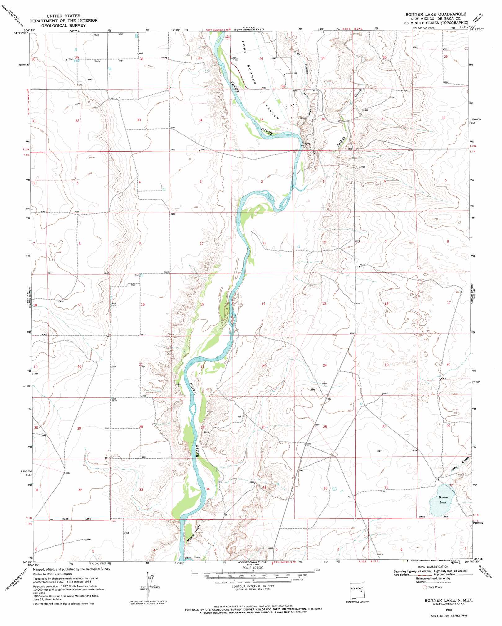
USGS Topo Quad 34104c2 - 1:24,000 scale
| Topo Map Name: | Bonner Lake |
| USGS Topo Quad ID: | 34104c2 |
| Print Size: | ca. 21 1/4" wide x 27" high |
| Southeast Coordinates: | 34.25° N latitude / 104.125° W longitude |
| Map Center Coordinates: | 34.3125° N latitude / 104.1875° W longitude |
| U.S. State: | NM |
| Filename: | o34104c2.jpg |
| Download Map JPG Image: | Bonner Lake topo map 1:24,000 scale |
| Map Type: | Topographic |
| Topo Series: | 7.5´ |
| Map Scale: | 1:24,000 |
| Source of Map Images: | United States Geological Survey (USGS) |
| Alternate Map Versions: |
Bonner Lake NM 1968, updated 1971 Download PDF Buy paper map Bonner Lake NM 2010 Download PDF Buy paper map Bonner Lake NM 2013 Download PDF Buy paper map Bonner Lake NM 2017 Download PDF Buy paper map |
1:24,000 Topo Quads surrounding Bonner Lake
Alamogordo Dam |
Windmill Draw |
Twin Mesa |
Candy Mesa |
Peach Canyon |
Ricardo |
Fort Sumner West |
Fort Sumner East |
Taiban |
Tolar |
West Camp |
Alamo Ranch |
Bonner Lake |
Lomas Gatos |
Tolar Sw |
Conejo Creek West |
Conejo Creek East |
Eighteenmile Hill |
Watts Hill |
Gammil Well |
Lovelady Draw |
La Espia Peak |
Cooley Lake |
Howell Ranch |
Rippee Ranch |
> Back to 34104a1 at 1:100,000 scale
> Back to 34104a1 at 1:250,000 scale
> Back to U.S. Topo Maps home
Bonner Lake topo map: Gazetteer
Bonner Lake: Lakes
Bonner Lake elevation 1225m 4019′Bonner Lake: Streams
Cibolo Creek elevation 1180m 3871′Taiban Creek elevation 1193m 3914′
Bonner Lake: Summits
Mesita Negra elevation 1186m 3891′Bonner Lake: Valleys
Cañon Blanco elevation 1225m 4019′Fort Sumner Valley elevation 1195m 3920′
Bonner Lake: Wells
10000 Water Well elevation 1217m 3992′10001 Water Well elevation 1215m 3986′
10030 Water Well elevation 1202m 3943′
10088 Water Well elevation 1217m 3992′
10090 Water Well elevation 1241m 4071′
10091 Water Well elevation 1215m 3986′
10092 Water Well elevation 1213m 3979′
10093 Water Well elevation 1214m 3982′
10094 Water Well elevation 1211m 3973′
10095 Water Well elevation 1235m 4051′
10096 Water Well elevation 1227m 4025′
10097 Water Well elevation 1227m 4025′
10099 Water Well elevation 1210m 3969′
10100 Water Well elevation 1206m 3956′
10101 Water Well elevation 1205m 3953′
10102 Water Well elevation 1199m 3933′
10103 Water Well elevation 1200m 3937′
10104 Water Well elevation 1214m 3982′
10105 Water Well elevation 1205m 3953′
10107 Water Well elevation 1216m 3989′
10108 Water Well elevation 1229m 4032′
10110 Water Well elevation 1242m 4074′
10111 Water Well elevation 1227m 4025′
10112 Water Well elevation 1237m 4058′
10114 Water Well elevation 1226m 4022′
10115 Water Well elevation 1228m 4028′
10116 Water Well elevation 1228m 4028′
10208 Water Well elevation 1225m 4019′
10209 Water Well elevation 1219m 3999′
10851 Water Well elevation 1219m 3999′
20000 Water Well elevation 1217m 3992′
Bonner Lake digital topo map on disk
Buy this Bonner Lake topo map showing relief, roads, GPS coordinates and other geographical features, as a high-resolution digital map file on DVD: