Peach Canyon Topo Map New Mexico
To zoom in, hover over the map of Peach Canyon
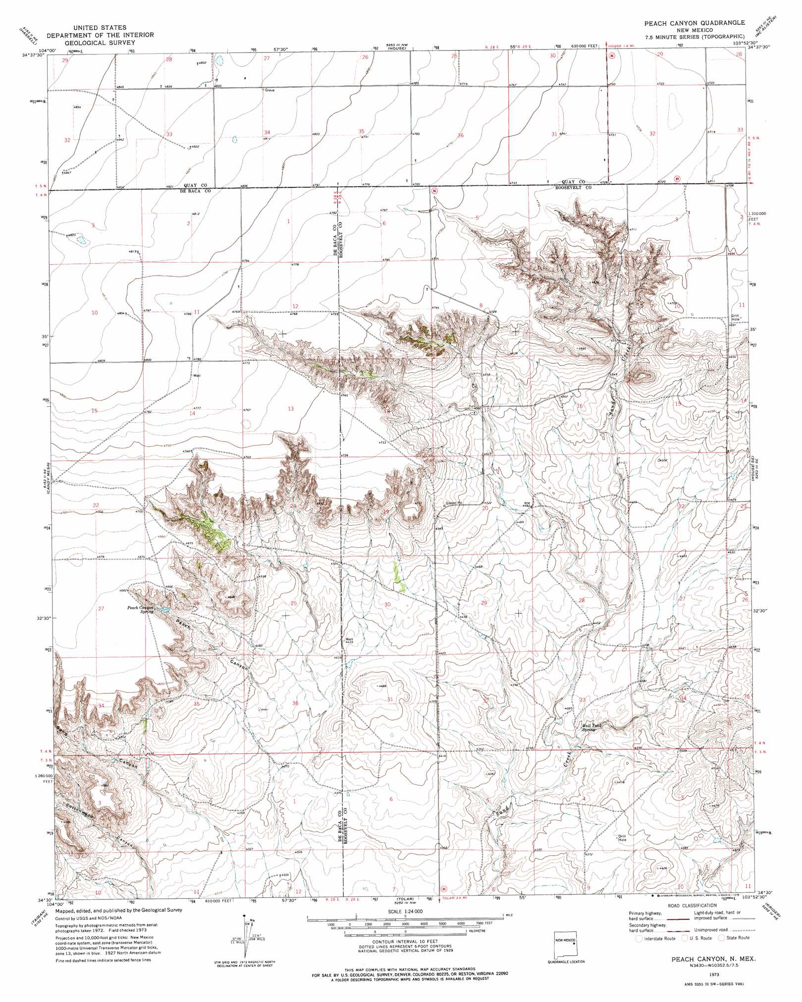
USGS Topo Quad 34103e8 - 1:24,000 scale
| Topo Map Name: | Peach Canyon |
| USGS Topo Quad ID: | 34103e8 |
| Print Size: | ca. 21 1/4" wide x 27" high |
| Southeast Coordinates: | 34.5° N latitude / 103.875° W longitude |
| Map Center Coordinates: | 34.5625° N latitude / 103.9375° W longitude |
| U.S. State: | NM |
| Filename: | o34103e8.jpg |
| Download Map JPG Image: | Peach Canyon topo map 1:24,000 scale |
| Map Type: | Topographic |
| Topo Series: | 7.5´ |
| Map Scale: | 1:24,000 |
| Source of Map Images: | United States Geological Survey (USGS) |
| Alternate Map Versions: |
Peach Canyon NM 1973, updated 1975 Download PDF Buy paper map Peach Canyon NM 2010 Download PDF Buy paper map Peach Canyon NM 2013 Download PDF Buy paper map Peach Canyon NM 2017 Download PDF Buy paper map |
1:24,000 Topo Quads surrounding Peach Canyon
Ima Sw |
Ima Se |
Cunavea Basin |
Jordan |
Ragland |
Twin Mesa Nw |
Hassell |
House |
Mcalister |
Weber City |
Twin Mesa |
Candy Mesa |
Peach Canyon |
House Se |
Field Sw |
Fort Sumner East |
Taiban |
Tolar |
Krider |
Melrose West |
Bonner Lake |
Lomas Gatos |
Tolar Sw |
Tolar Se |
Tule Lake |
> Back to 34103e1 at 1:100,000 scale
> Back to 34102a1 at 1:250,000 scale
> Back to U.S. Topo Maps home
Peach Canyon topo map: Gazetteer
Peach Canyon: Springs
Bull Tank Spring elevation 1324m 4343′Peach Canyon Spring elevation 1406m 4612′
Peach Canyon: Valleys
Cottonwood Canyon elevation 1319m 4327′Peach Canyon elevation 1349m 4425′
Sand Canyon elevation 1325m 4347′
Peach Canyon: Wells
06032 Water Well elevation 1384m 4540′06038 Water Well elevation 1351m 4432′
06039 Water Well elevation 1365m 4478′
06040 Water Well elevation 1366m 4481′
06041 Water Well elevation 1437m 4714′
10209 Water Well elevation 1457m 4780′
10237 Water Well elevation 1472m 4829′
10238 Water Well elevation 1475m 4839′
10242 Water Well elevation 1478m 4849′
10243 Water Well elevation 1476m 4842′
10244 Water Well elevation 1471m 4826′
10245 Water Well elevation 1465m 4806′
10246 Water Well elevation 1459m 4786′
10247 Water Well elevation 1453m 4767′
10248 Water Well elevation 1453m 4767′
10297 Water Well elevation 1400m 4593′
10300 Water Well elevation 1385m 4543′
10301 Water Well elevation 1363m 4471′
10339 Water Well elevation 1333m 4373′
10342 Water Well elevation 1319m 4327′
10343 Water Well elevation 1311m 4301′
10344 Water Well elevation 1311m 4301′
10555 Water Well elevation 1471m 4826′
10556 Water Well elevation 1464m 4803′
10559 WAter Well elevation 1465m 4806′
10560 Water Well elevation 1456m 4776′
10561 Water Well elevation 1458m 4783′
10562 Water Well elevation 1448m 4750′
10568 Water Well elevation 1437m 4714′
10569 Water Well elevation 1436m 4711′
10623 Water Well elevation 1439m 4721′
10624 Water Well elevation 1442m 4730′
10625 Water Well elevation 1459m 4786′
10626 Water Well elevation 1440m 4724′
10653 Water Well elevation 1447m 4747′
10718 Water Well elevation 1441m 4727′
11693 Water Well elevation 1446m 4744′
11694 Water Well elevation 1443m 4734′
11695 Water Well elevation 1360m 4461′
12251 Water Well elevation 1336m 4383′
12252 Water Well elevation 1349m 4425′
12500 Water Well elevation 1357m 4452′
Peach Canyon digital topo map on disk
Buy this Peach Canyon topo map showing relief, roads, GPS coordinates and other geographical features, as a high-resolution digital map file on DVD: