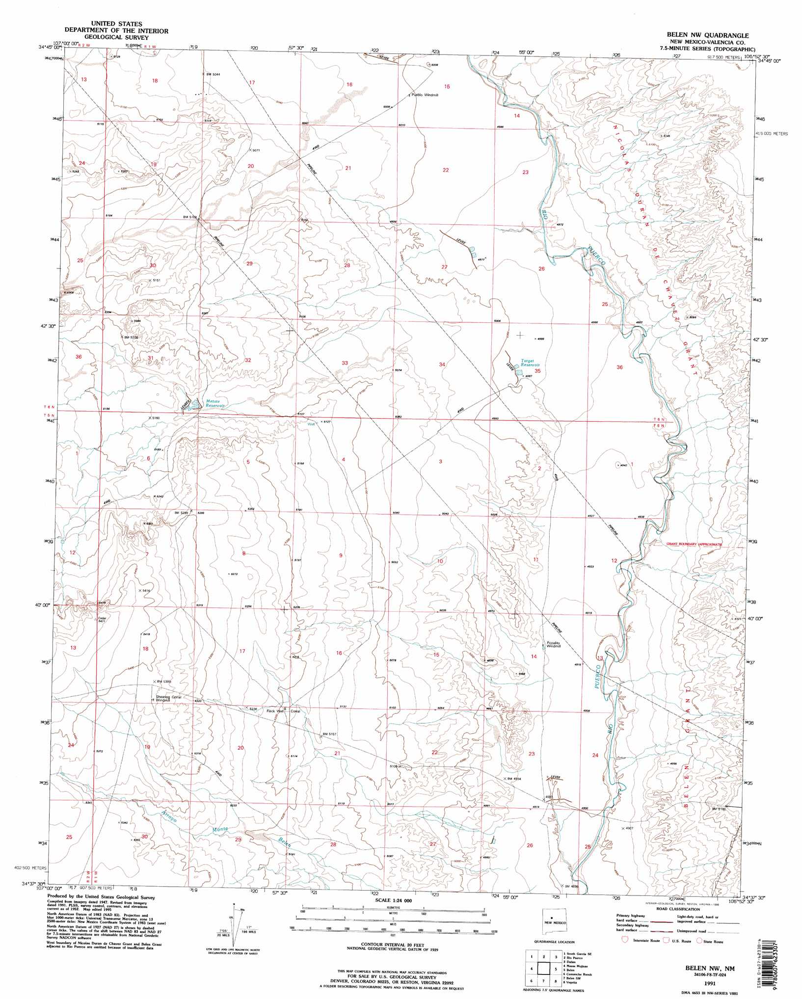
Belen Nw Topo Map New Mexico
To zoom in, hover over the map of Belen Nw
USGS Topo Quad 34106f8 - 1:24,000 scale
| Topo Map Name: | Belen Nw |
| USGS Topo Quad ID: | 34106f8 |
| Print Size: | ca. 21 1/4" wide x 27" high |
| Southeast Coordinates: | 34.625° N latitude / 106.875° W longitude |
| Map Center Coordinates: | 34.6875° N latitude / 106.9375° W longitude |
| U.S. State: | NM |
| Filename: | o34106f8.jpg |
| Download Map JPG Image: | Belen Nw topo map 1:24,000 scale |
| Map Type: | Topographic |
| Topo Series: | 7.5´ |
| Map Scale: | 1:24,000 |
| Source of Map Images: | United States Geological Survey (USGS) |
| Alternate Map Versions: |
Belen NW NM 1952, updated 1953 Download PDF Buy paper map Belen NW NM 1952, updated 1953 Download PDF Buy paper map Belen NW NM 1952, updated 1980 Download PDF Buy paper map Belen NW NM 1991, updated 1996 Download PDF Buy paper map Belen NW NM 2010 Download PDF Buy paper map Belen NW NM 2013 Download PDF Buy paper map Belen NW NM 2017 Download PDF Buy paper map |
1:24,000 Topo Quads surrounding Belen Nw
Correo |
South Garcia |
Dalies Nw |
Wind Mesa |
Isleta |
White Ridge |
South Garcia Se |
Rio Puerco |
Dalies |
Los Lunas |
Mesa Gallina |
Mesas Mojinas |
Belen Nw |
Belen |
Tome |
Mesa Sarca |
Comanche Ranch |
Belen Sw |
Veguita |
Turn |
Riley |
Ladron Peak |
La Joya Nw |
Abeytas |
Black Butte |
> Back to 34106e1 at 1:100,000 scale
> Back to 34106a1 at 1:250,000 scale
> Back to U.S. Topo Maps home
Belen Nw topo map: Gazetteer
Belen Nw: Reservoirs
Escondido Reservoir elevation 1614m 5295′Gabaladon Reservoir elevation 1584m 5196′
Gabaldon Reservoir elevation 1579m 5180′
Guzman Reservoir elevation 1518m 4980′
Metate Reservoir elevation 1564m 5131′
Target Reservoir elevation 1523m 4996′
Belen Nw: Streams
Arroyo Monte Belen elevation 1498m 4914′Arroyo Monte Belen elevation 1499m 4917′
Belen Nw: Wells
10023 Water Well elevation 1502m 4927′10025 Water Well elevation 1525m 5003′
Flack Well elevation 1584m 5196′
Popalito Water Well elevation 1513m 4963′
Shell Water Well elevation 1576m 5170′
Belen Nw digital topo map on disk
Buy this Belen Nw topo map showing relief, roads, GPS coordinates and other geographical features, as a high-resolution digital map file on DVD: