Pasture Canyon Topo Map New Mexico
To zoom in, hover over the map of Pasture Canyon
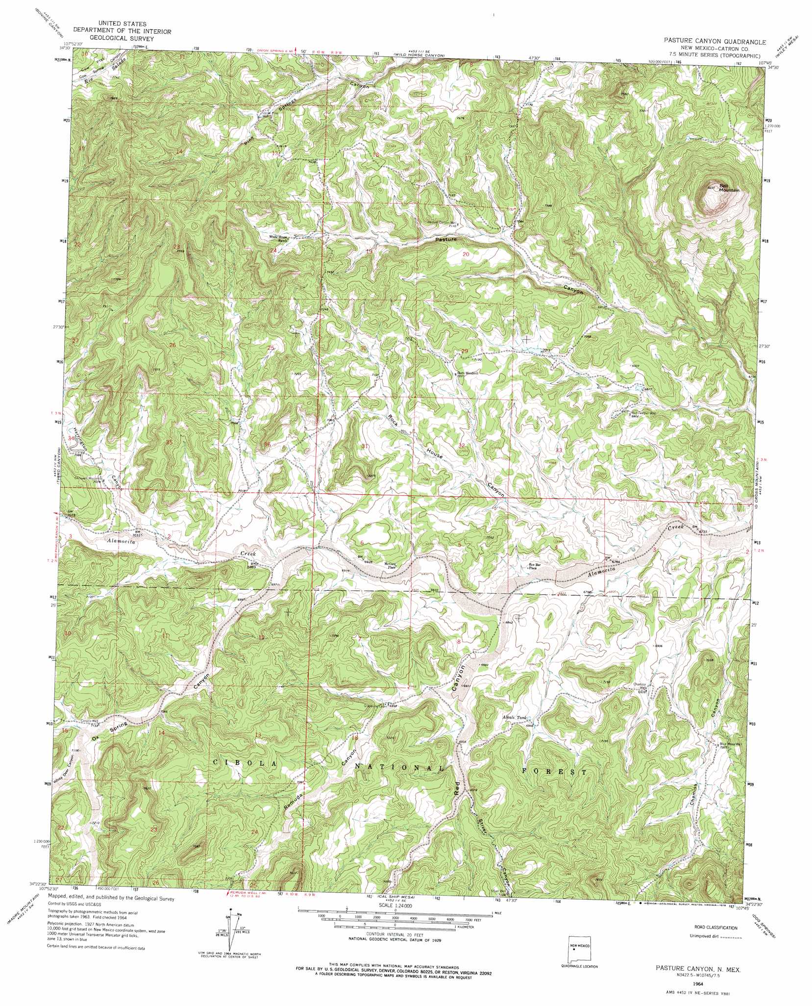
USGS Topo Quad 34107d7 - 1:24,000 scale
| Topo Map Name: | Pasture Canyon |
| USGS Topo Quad ID: | 34107d7 |
| Print Size: | ca. 21 1/4" wide x 27" high |
| Southeast Coordinates: | 34.375° N latitude / 107.75° W longitude |
| Map Center Coordinates: | 34.4375° N latitude / 107.8125° W longitude |
| U.S. State: | NM |
| Filename: | o34107d7.jpg |
| Download Map JPG Image: | Pasture Canyon topo map 1:24,000 scale |
| Map Type: | Topographic |
| Topo Series: | 7.5´ |
| Map Scale: | 1:24,000 |
| Source of Map Images: | United States Geological Survey (USGS) |
| Alternate Map Versions: |
Pasture Canyon NM 1964, updated 1967 Download PDF Buy paper map Pasture Canyon NM 1964, updated 1978 Download PDF Buy paper map Pasture Canyon NM 1995, updated 1998 Download PDF Buy paper map Pasture Canyon NM 2011 Download PDF Buy paper map Pasture Canyon NM 2013 Download PDF Buy paper map Pasture Canyon NM 2017 Download PDF Buy paper map |
| FStopo: | US Forest Service topo Pasture Canyon is available: Download FStopo PDF Download FStopo TIF |
1:24,000 Topo Quads surrounding Pasture Canyon
York Ranch |
Sand Canyon |
Cebollita Peak |
Mecate Meadow |
Broom Mountain |
York Ranch Se |
Bonine Canyon |
Wild Horse Canyon |
Wiley Mesa |
Pueblo Viejo Mesa |
Tres Lagunas |
Third Canyon |
Pasture Canyon |
D Cross Mountain |
Table Mountain |
Red Flats |
Madre Mountain |
Cal Ship Mesa |
Dog Springs |
Indian Mesa |
Cox Peak |
Crosby Springs |
Datil |
Lion Mountain Nw |
Lion Mountain |
> Back to 34107a1 at 1:100,000 scale
> Back to 34106a1 at 1:250,000 scale
> Back to U.S. Topo Maps home
Pasture Canyon topo map: Gazetteer
Pasture Canyon: Flats
Cow Flat elevation 2379m 7805′Pasture Canyon: Populated Places
Box Bar Place elevation 2085m 6840′McCord Place elevation 2109m 6919′
Pasture Canyon: Reservoirs
Alkali Tank elevation 2119m 6952′Pasture Canyon: Summits
Bell Mountain elevation 2507m 8225′Pasture Canyon: Valleys
Chamisa Canyon elevation 2048m 6719′Harrington Canyon elevation 2140m 7020′
Ox Spring Canyon elevation 2120m 6955′
Red Canyon elevation 2083m 6833′
Remuda Canyon elevation 2104m 6902′
Rock House Canyon elevation 2060m 6758′
Stiver Canyon elevation 2126m 6975′
White Deer Canyon elevation 2181m 7155′
Pasture Canyon: Wells
Blue Mesa Well elevation 2143m 7030′Canyon Well elevation 2173m 7129′
Chamisa Well elevation 2115m 6938′
Pasture Canyon Well elevation 2166m 7106′
Red Feather Well elevation 2109m 6919′
Stiver Well elevation 2171m 7122′
Upper Pine Well elevation 2227m 7306′
Pasture Canyon digital topo map on disk
Buy this Pasture Canyon topo map showing relief, roads, GPS coordinates and other geographical features, as a high-resolution digital map file on DVD: