Forest Falls Topo Map California
To zoom in, hover over the map of Forest Falls
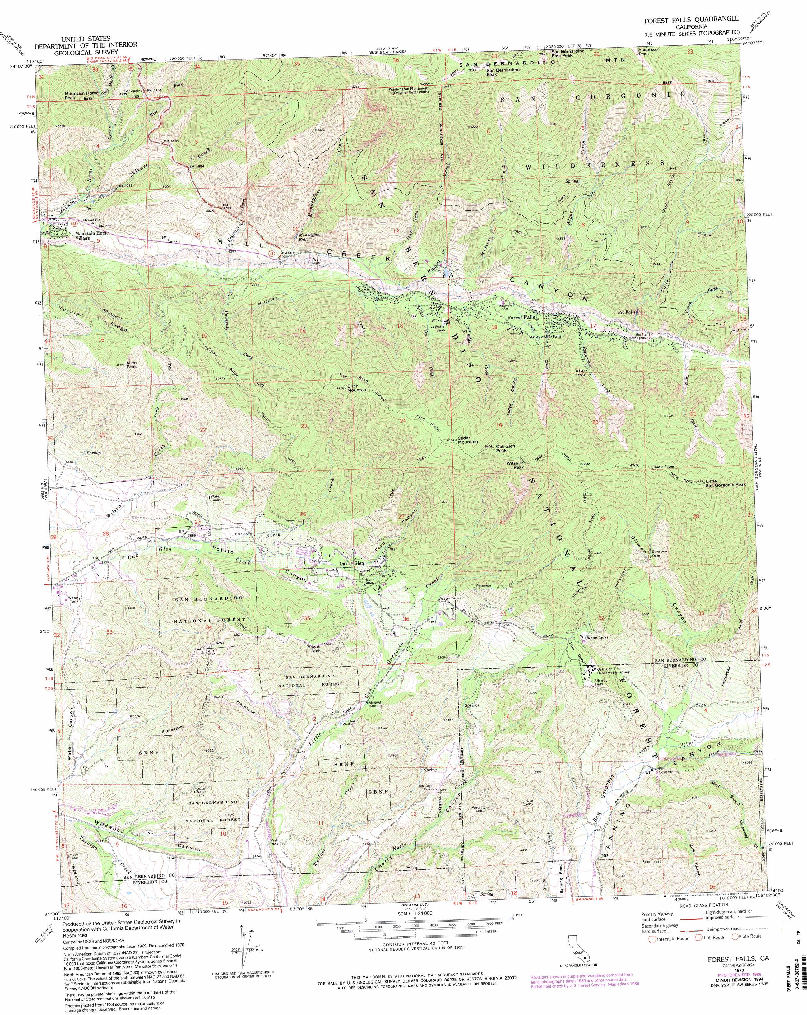
USGS Topo Quad 34116a8 - 1:24,000 scale
| Topo Map Name: | Forest Falls |
| USGS Topo Quad ID: | 34116a8 |
| Print Size: | ca. 21 1/4" wide x 27" high |
| Southeast Coordinates: | 34° N latitude / 116.875° W longitude |
| Map Center Coordinates: | 34.0625° N latitude / 116.9375° W longitude |
| U.S. State: | CA |
| Filename: | o34116a8.jpg |
| Download Map JPG Image: | Forest Falls topo map 1:24,000 scale |
| Map Type: | Topographic |
| Topo Series: | 7.5´ |
| Map Scale: | 1:24,000 |
| Source of Map Images: | United States Geological Survey (USGS) |
| Alternate Map Versions: |
Forest Falls CA 1970, updated 1975 Download PDF Buy paper map Forest Falls CA 1970, updated 1988 Download PDF Buy paper map Forest Falls CA 1970, updated 1994 Download PDF Buy paper map Forest Falls CA 1996, updated 1999 Download PDF Buy paper map Forest Falls CA 2012 Download PDF Buy paper map Forest Falls CA 2015 Download PDF Buy paper map |
| FStopo: | US Forest Service topo Forest Falls is available: Download FStopo PDF Download FStopo TIF |
1:24,000 Topo Quads surrounding Forest Falls
Lake Arrowhead |
Butler Peak |
Fawnskin |
Big Bear City |
Rattlesnake Canyon |
Harrison Mountain |
Keller Peak |
Big Bear Lake |
Moonridge |
Onyx Peak |
Redlands |
Yucaipa |
Forest Falls |
San Gorgonio Mountain |
Catclaw Flat |
Sunnymead |
El Casco |
Beaumont |
Cabazon |
White Water |
Perris |
Lakeview |
San Jacinto |
Lake Fulmor |
San Jacinto Peak |
> Back to 34116a1 at 1:100,000 scale
> Back to 34116a1 at 1:250,000 scale
> Back to U.S. Topo Maps home
Forest Falls topo map: Gazetteer
Forest Falls: Benches
Pine Bench elevation 1616m 5301′Pine Bench elevation 1687m 5534′
Forest Falls: Falls
Big Falls elevation 1897m 6223′Monkeyface Falls elevation 1562m 5124′
Valley of the Falls elevation 1742m 5715′
Forest Falls: Parks
Washington Monument elevation 3086m 10124′Forest Falls: Populated Places
Forest Falls elevation 1628m 5341′Mountain Home Village elevation 1125m 3690′
Oak Glen elevation 1465m 4806′
Forest Falls: Post Offices
Forest Falls Post Office elevation 1697m 5567′Forest Falls: Streams
Alger Creek elevation 1659m 5442′Birch Creek elevation 1037m 3402′
Bridal Veil Creek elevation 1494m 4901′
Camp Creek elevation 1882m 6174′
East Fork Mountain Home Creek elevation 1306m 4284′
Falls Creek elevation 1793m 5882′
Frustration Creek elevation 1259m 4130′
Glen Martin Creek elevation 1388m 4553′
Hatchery Creek elevation 1506m 4940′
Momyer Creek elevation 1557m 5108′
Monkeyface Creek elevation 1372m 4501′
Oak Cove Creek elevation 1379m 4524′
Oak Creek elevation 1433m 4701′
Rattlesnake Creek elevation 1729m 5672′
Skinner Creek elevation 1177m 3861′
Slide Creek elevation 1570m 5150′
Snow Creek elevation 1641m 5383′
University Creek elevation 1288m 4225′
Vivian Creek elevation 1867m 6125′
Forest Falls: Summits
Allen Peak elevation 1761m 5777′Anderson Peak elevation 3304m 10839′
Birch Mountain elevation 2385m 7824′
Cedar Mountain elevation 2526m 8287′
Little San Gorgonio Peak elevation 2785m 9137′
Mountain Home Peak elevation 1768m 5800′
Oak Glen Peak elevation 2545m 8349′
Pisgah Peak elevation 1673m 5488′
San Bernadino Peak elevation 3224m 10577′
San Bernardino East Peak elevation 3236m 10616′
San Bernardino Mountain elevation 3304m 10839′
Wilshire Peak elevation 2642m 8667′
Forest Falls: Trails
Falls Creek Trail elevation 2665m 8743′Oak Glen Divide Trail elevation 2403m 7883′
Wilshire Peak Trail elevation 2282m 7486′
Yucaipa Ridge Truck Trail elevation 1812m 5944′
Forest Falls: Valleys
Ford Canyon elevation 1502m 4927′Gilman Canyon elevation 1333m 4373′
Lodge Canyon elevation 1902m 6240′
Potato Canyon elevation 1139m 3736′
Forest Falls digital topo map on disk
Buy this Forest Falls topo map showing relief, roads, GPS coordinates and other geographical features, as a high-resolution digital map file on DVD: