Oswald Dome Topo Map Tennessee
To zoom in, hover over the map of Oswald Dome
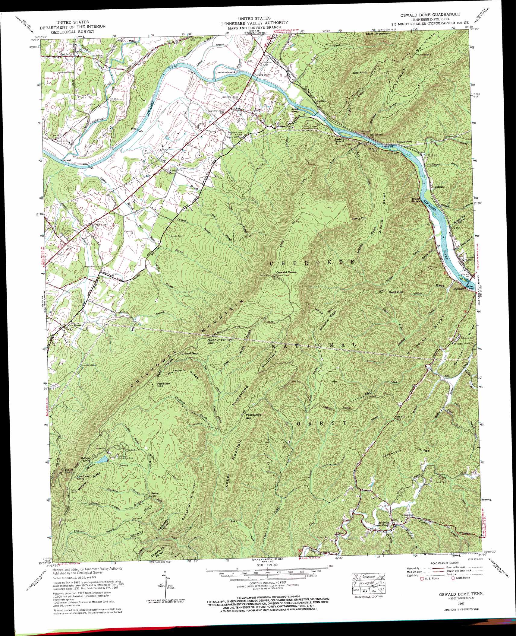
USGS Topo Quad 35084b5 - 1:24,000 scale
| Topo Map Name: | Oswald Dome |
| USGS Topo Quad ID: | 35084b5 |
| Print Size: | ca. 21 1/4" wide x 27" high |
| Southeast Coordinates: | 35.125° N latitude / 84.5° W longitude |
| Map Center Coordinates: | 35.1875° N latitude / 84.5625° W longitude |
| U.S. State: | TN |
| Filename: | o35084b5.jpg |
| Download Map JPG Image: | Oswald Dome topo map 1:24,000 scale |
| Map Type: | Topographic |
| Topo Series: | 7.5´ |
| Map Scale: | 1:24,000 |
| Source of Map Images: | United States Geological Survey (USGS) |
| Alternate Map Versions: |
Oswald Bald TN 1935 Download PDF Buy paper map Oswald Dome TN 1937, updated 1954 Download PDF Buy paper map Oswald Dome TN 1938 Download PDF Buy paper map Oswald Dome TN 1967, updated 1970 Download PDF Buy paper map Oswald Dome TN 1967, updated 1970 Download PDF Buy paper map Oswald Dome TN 2003, updated 2004 Download PDF Buy paper map Oswald Dome TN 2011 Download PDF Buy paper map Oswald Dome TN 2013 Download PDF Buy paper map Oswald Dome TN 2016 Download PDF Buy paper map |
| FStopo: | US Forest Service topo Oswald Dome is available: Download FStopo PDF Download FStopo TIF |
1:24,000 Topo Quads surrounding Oswald Dome
Goodfield |
Riceville |
Athens |
Englewood |
Mount Vernon |
Charleston |
Calhoun |
Etowah |
Mecca |
Tellico Plains |
East Cleveland |
Benton |
Oswald Dome |
Mcfarland |
Farner |
Felker |
Parksville |
Caney Creek |
Ducktown |
Isabella |
Beaverdale |
Tennga |
Hemp Top |
Epworth |
Mineral Bluff |
> Back to 35084a1 at 1:100,000 scale
> Back to 35084a1 at 1:250,000 scale
> Back to U.S. Topo Maps home
Oswald Dome topo map: Gazetteer
Oswald Dome: Airports
Chilhowee Airport elevation 234m 767′Oswald Dome: Bars
Broad Shoals elevation 222m 728′Oswald Dome: Bends
Loop A elevation 591m 1938′Loop B elevation 589m 1932′
Loop C, D, E, and F elevation 560m 1837′
Oswald Dome: Bridges
Harbnson Bridge elevation 216m 708′Oswald Dome: Crossings
Savannah Ford elevation 215m 705′Oswald Dome: Dams
Lake Agape Dam elevation 239m 784′McCamy Dam elevation 579m 1899′
McKomey Dam elevation 537m 1761′
Oswald Dome: Falls
Benton Falls elevation 500m 1640′Oswald Dome: Gaps
Deep Gap elevation 359m 1177′Hiwassee Gap elevation 218m 715′
Lillard Gap elevation 551m 1807′
Mulepen Gap elevation 593m 1945′
Presswood Gap elevation 430m 1410′
Sulphur Springs Gap elevation 579m 1899′
Oswald Dome: Islands
Jenkins Island elevation 219m 718′Long Island elevation 217m 711′
Taylors Island elevation 220m 721′
Oswald Dome: Parks
Chilhowee Recreation Area elevation 563m 1847′Clemmer Campsite elevation 543m 1781′
Hiwassee River Recreation Area elevation 230m 754′
Lost Corral Recreation Area elevation 226m 741′
Quinn Springs Recreation Area elevation 225m 738′
Rock Creek Scenic Area elevation 458m 1502′
Oswald Dome: Populated Places
Archville elevation 319m 1046′Austral elevation 229m 751′
Benton Springs elevation 482m 1581′
Columbus (historical) elevation 227m 744′
Hambright elevation 232m 761′
Oak Grove elevation 244m 800′
Old Patty elevation 227m 744′
Oswald Dome: Reservoirs
Lake Agape elevation 239m 784′McCamy Lake elevation 579m 1899′
McKomey Lake elevation 537m 1761′
Oswald Dome: Ridges
Chilhowee Mountain elevation 914m 2998′Drypond Ridge elevation 608m 1994′
Graveyard Ridge elevation 359m 1177′
McCamy Ridge elevation 676m 2217′
Millpoint Ridge elevation 369m 1210′
Millstone Ridge elevation 586m 1922′
Mulepen Ridge elevation 609m 1998′
Parchcorn Ridge elevation 359m 1177′
Oswald Dome: Springs
Big Spring elevation 230m 754′McCamy Spring elevation 583m 1912′
Ram Pump Spring elevation 595m 1952′
Oswald Dome: Streams
Bates Branch elevation 276m 905′Biggs Spring Branch elevation 448m 1469′
Campbell Branch elevation 299m 980′
Carney Branch elevation 248m 813′
Coffee Branch elevation 218m 715′
Conasauga Creek elevation 210m 688′
Dairy Branch elevation 217m 711′
Dry Branch elevation 237m 777′
Drypond Branch elevation 349m 1145′
Dunn Branch elevation 262m 859′
Franklin Spring Branch elevation 497m 1630′
Gee Creek elevation 217m 711′
Hancock Licklog Branch elevation 479m 1571′
Hawkins Branch elevation 216m 708′
Higdon Branch elevation 309m 1013′
Hopper Branch elevation 222m 728′
Horton Branch elevation 208m 682′
Junebug Creek elevation 226m 741′
Laurel Branch elevation 367m 1204′
Left Prong Hiwassee River elevation 219m 718′
Lillard Branch elevation 210m 688′
Long Branch elevation 281m 921′
Lowry Branch elevation 282m 925′
McCamy Branch elevation 529m 1735′
Mulepen Branch elevation 407m 1335′
Nicholson Branch elevation 230m 754′
Parker Branch elevation 257m 843′
Parris Branch elevation 235m 770′
Pell Branch elevation 214m 702′
Presswood Branch elevation 224m 734′
Prock Branch elevation 266m 872′
Right Prong Junebug Creek elevation 274m 898′
Ritchie Branch elevation 248m 813′
Ruckers Branch elevation 223m 731′
Siccowee Branch elevation 219m 718′
Silvermine Branch elevation 484m 1587′
Slickrock Branch elevation 429m 1407′
Spanking Slump Branch elevation 221m 725′
Spring Creek elevation 221m 725′
Spring Falls Branch elevation 224m 734′
Tieskee Creek elevation 224m 734′
Toby Stone Branch elevation 224m 734′
Watertank Branch elevation 223m 731′
Wildcat Branch elevation 234m 767′
Oswald Dome: Summits
Bean Mountain elevation 918m 3011′Chestnut Mountain elevation 595m 1952′
Gee Knob elevation 599m 1965′
Hooper Mountain elevation 529m 1735′
Lowry Top elevation 819m 2687′
Oswald Dome elevation 914m 2998′
Presswood Mountain elevation 701m 2299′
Starr Mountain elevation 564m 1850′
Oswald Dome: Trails
Arbutus Trail elevation 577m 1893′Azalea Trail elevation 550m 1804′
Benton Falls Trail elevation 538m 1765′
Big Pine Trail elevation 546m 1791′
Chestnut Mountain Trail elevation 783m 2568′
Chilhowee Forest Walk Trail elevation 609m 1998′
Clear Creek Trail elevation 555m 1820′
Clemmer Trail elevation 507m 1663′
Fishermans Trail elevation 558m 1830′
Gee Creek Trail elevation 304m 997′
Lowry Cove Trail elevation 768m 2519′
Lowry Falls Trail elevation 348m 1141′
Oswald Dome Trail elevation 489m 1604′
Redleaf Trail elevation 547m 1794′
Spanking Stump Trail elevation 265m 869′
Oswald Dome: Valleys
Deep Hollow elevation 463m 1519′Ernie King Hollow elevation 232m 761′
Rattlesnake Hollow elevation 410m 1345′
Oswald Dome digital topo map on disk
Buy this Oswald Dome topo map showing relief, roads, GPS coordinates and other geographical features, as a high-resolution digital map file on DVD: