Etowah Topo Map Tennessee
To zoom in, hover over the map of Etowah
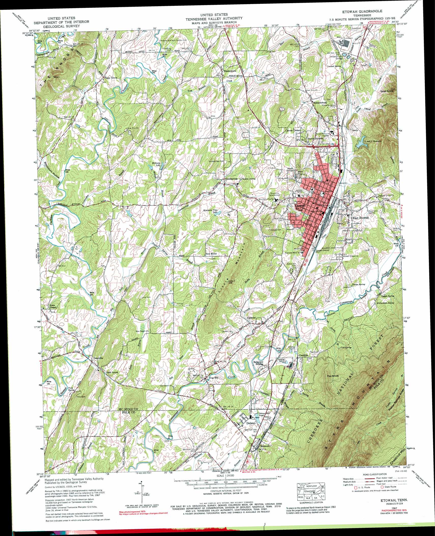
USGS Topo Quad 35084c5 - 1:24,000 scale
| Topo Map Name: | Etowah |
| USGS Topo Quad ID: | 35084c5 |
| Print Size: | ca. 21 1/4" wide x 27" high |
| Southeast Coordinates: | 35.25° N latitude / 84.5° W longitude |
| Map Center Coordinates: | 35.3125° N latitude / 84.5625° W longitude |
| U.S. State: | TN |
| Filename: | o35084c5.jpg |
| Download Map JPG Image: | Etowah topo map 1:24,000 scale |
| Map Type: | Topographic |
| Topo Series: | 7.5´ |
| Map Scale: | 1:24,000 |
| Source of Map Images: | United States Geological Survey (USGS) |
| Alternate Map Versions: |
Etowah TN 1935 Download PDF Buy paper map Etowah TN 1943, updated 1960 Download PDF Buy paper map Etowah TN 1943, updated 1963 Download PDF Buy paper map Etowah TN 1944, updated 1946 Download PDF Buy paper map Etowah TN 1967, updated 1970 Download PDF Buy paper map Etowah TN 1967, updated 1989 Download PDF Buy paper map Etowah TN 1967, updated 1989 Download PDF Buy paper map Etowah TN 2003, updated 2004 Download PDF Buy paper map Etowah TN 2011 Download PDF Buy paper map Etowah TN 2013 Download PDF Buy paper map Etowah TN 2016 Download PDF Buy paper map |
| FStopo: | US Forest Service topo Etowah is available: Download FStopo PDF Download FStopo TIF |
1:24,000 Topo Quads surrounding Etowah
Decatur |
Tranquillity |
Niota |
Sweetwater |
Madisonville |
Goodfield |
Riceville |
Athens |
Englewood |
Mount Vernon |
Charleston |
Calhoun |
Etowah |
Mecca |
Tellico Plains |
East Cleveland |
Benton |
Oswald Dome |
Mcfarland |
Farner |
Felker |
Parksville |
Caney Creek |
Ducktown |
Isabella |
> Back to 35084a1 at 1:100,000 scale
> Back to 35084a1 at 1:250,000 scale
> Back to U.S. Topo Maps home
Etowah topo map: Gazetteer
Etowah: Dams
L and N Reservoir Dam elevation 254m 833′Etowah: Lakes
Delano Mill Pond elevation 237m 777′Etowah: Populated Places
Balltown elevation 259m 849′Belleview Estates elevation 230m 754′
Cambria elevation 238m 780′
Carlock elevation 232m 761′
Delano elevation 239m 784′
Dentville elevation 232m 761′
East Etowah elevation 249m 816′
Etowah elevation 246m 807′
Goodsprings elevation 249m 816′
Goosetown elevation 278m 912′
Grady elevation 271m 889′
New Bethel elevation 265m 869′
North Etowah elevation 268m 879′
Piney Grove elevation 244m 800′
Seven Cedars elevation 282m 925′
Wesleyanna elevation 245m 803′
Wetmore elevation 248m 813′
Williamsburg elevation 278m 912′
Yancey (historical) elevation 253m 830′
Etowah: Post Offices
Delano Post Office elevation 239m 784′Etowah Post Office elevation 249m 816′
Etowah: Reservoirs
L and N Reservoir elevation 254m 833′Mountain View Lake elevation 256m 839′
Williams Lake elevation 244m 800′
Etowah: Springs
Cave Spring elevation 263m 862′Chestnut Spring elevation 242m 793′
Crockett Spring elevation 263m 862′
Davis Spring elevation 278m 912′
Dodd Spring elevation 231m 757′
Fowler Spring elevation 238m 780′
McSpadden Spring elevation 254m 833′
Plumlee Spring elevation 267m 875′
Trew Spring elevation 227m 744′
Tuggle Spring elevation 237m 777′
Etowah: Streams
Big Foot Branch elevation 223m 731′Blair Branch elevation 240m 787′
Cane Creek elevation 223m 731′
Cave Spring Branch elevation 227m 744′
Coleman Spring Branch elevation 239m 784′
Crittenden Branch elevation 224m 734′
Crockett Spring Branch elevation 250m 820′
Culpepper Branch elevation 223m 731′
Double Springs Branch elevation 223m 731′
Goodsprings Branch elevation 230m 754′
Poplar Spring Branch elevation 229m 751′
Poplar Springs Branch elevation 504m 1653′
Red River Branch elevation 220m 721′
Rocky Branch elevation 231m 757′
Snake Island Branch elevation 263m 862′
Tom Foeman Creek elevation 230m 754′
Trew Branch elevation 220m 721′
Watson Branch elevation 232m 761′
Etowah: Summits
Chestnut Mountain elevation 768m 2519′Cog Hill elevation 227m 744′
Fox Knob elevation 384m 1259′
Goat Knob elevation 423m 1387′
Little Mountain elevation 302m 990′
Etowah: Valleys
Blackburn Hollow elevation 224m 734′Etowah digital topo map on disk
Buy this Etowah topo map showing relief, roads, GPS coordinates and other geographical features, as a high-resolution digital map file on DVD: