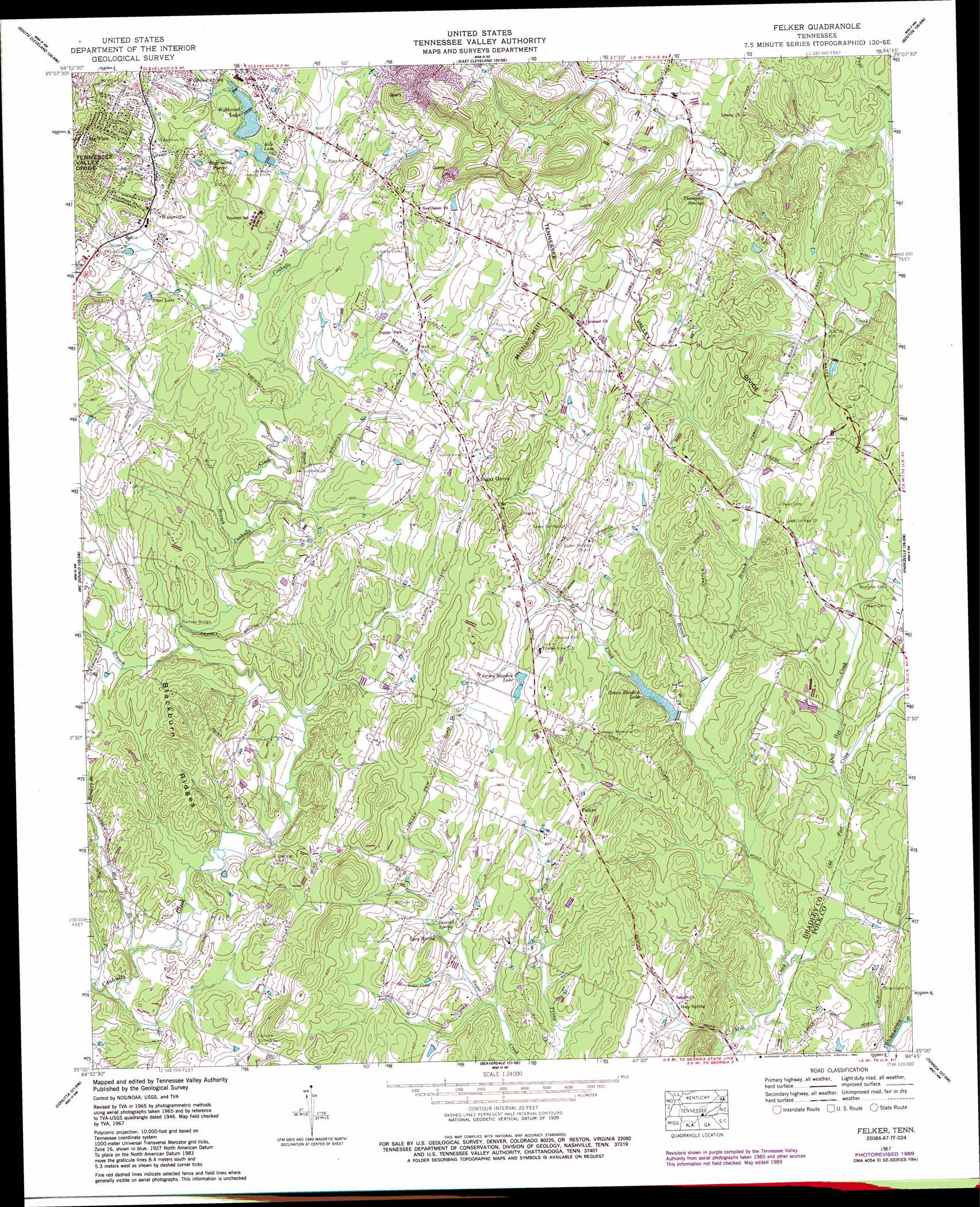
Felker Topo Map Tennessee
To zoom in, hover over the map of Felker
USGS Topo Quad 35084a7 - 1:24,000 scale
| Topo Map Name: | Felker |
| USGS Topo Quad ID: | 35084a7 |
| Print Size: | ca. 21 1/4" wide x 27" high |
| Southeast Coordinates: | 35° N latitude / 84.75° W longitude |
| Map Center Coordinates: | 35.0625° N latitude / 84.8125° W longitude |
| U.S. State: | TN |
| Filename: | o35084a7.jpg |
| Download Map JPG Image: | Felker topo map 1:24,000 scale |
| Map Type: | Topographic |
| Topo Series: | 7.5´ |
| Map Scale: | 1:24,000 |
| Source of Map Images: | United States Geological Survey (USGS) |
| Alternate Map Versions: |
Felker TN 1935 Download PDF Buy paper map Felker TN 1946, updated 1947 Download PDF Buy paper map Felker TN 1946, updated 1947 Download PDF Buy paper map Felker TN 1967, updated 1970 Download PDF Buy paper map Felker TN 1967, updated 1984 Download PDF Buy paper map Felker TN 1967, updated 1990 Download PDF Buy paper map Felker TN 2010 Download PDF Buy paper map Felker TN 2013 Download PDF Buy paper map Felker TN 2016 Download PDF Buy paper map |
1:24,000 Topo Quads surrounding Felker
Grasshopper Creek |
Birchwood |
Charleston |
Calhoun |
Etowah |
Snow Hill |
South Cleveland |
East Cleveland |
Benton |
Oswald Dome |
Ooltewah |
Mcdonald |
Felker |
Parksville |
Caney Creek |
Ringgold |
Cohutta |
Beaverdale |
Tennga |
Hemp Top |
Tunnel Hill |
Dalton North |
Chatsworth |
Crandall |
Dyer Gap |
> Back to 35084a1 at 1:100,000 scale
> Back to 35084a1 at 1:250,000 scale
> Back to U.S. Topo Maps home
Felker topo map: Gazetteer
Felker: Bridges
Ramsey Bridge elevation 239m 784′Felker: Dams
Green Shadow Dam elevation 238m 780′Felker: Populated Places
Bennett Acres elevation 270m 885′Cedar Spring elevation 256m 839′
Coahulla Ranch elevation 247m 810′
Earnest (historical) elevation 268m 879′
Felker elevation 253m 830′
Gap Spring elevation 239m 784′
Mount Vernon elevation 291m 954′
Nantahala Estates elevation 267m 875′
Pumpkin Center elevation 250m 820′
Sherwood Forest elevation 269m 882′
Sugar Grove elevation 269m 882′
Union elevation 243m 797′
Union Grove elevation 274m 898′
Waterville elevation 270m 885′
Wildwood Lake elevation 254m 833′
Williamsburg Estates elevation 280m 918′
Felker: Reservoirs
Green Shadow Lake elevation 238m 780′Hunt Lake elevation 262m 859′
Jersey Meadow Lake elevation 253m 830′
Kile Lake elevation 257m 843′
Wildwood Lake elevation 259m 849′
Felker: Ridges
Blackburn Ridges elevation 266m 872′Felker: Springs
Deverell Spring elevation 238m 780′Lacy Spring elevation 242m 793′
Thompson Springs elevation 243m 797′
Wildwood Spring elevation 266m 872′
Felker: Streams
Bird Branch elevation 236m 774′Blackburn Branch elevation 238m 780′
Carter Branch elevation 239m 784′
Dull Hoe Creek elevation 235m 770′
Hicks Branch elevation 245m 803′
Kinser Creek elevation 242m 793′
Old Fort Creek elevation 231m 757′
Red Hill Branch elevation 234m 767′
Sanders Branch elevation 242m 793′
Wolf Branch elevation 241m 790′
Felker: Summits
Million Hill elevation 319m 1046′Felker digital topo map on disk
Buy this Felker topo map showing relief, roads, GPS coordinates and other geographical features, as a high-resolution digital map file on DVD: