Bethany Ne Topo Map Oklahoma
To zoom in, hover over the map of Bethany Ne
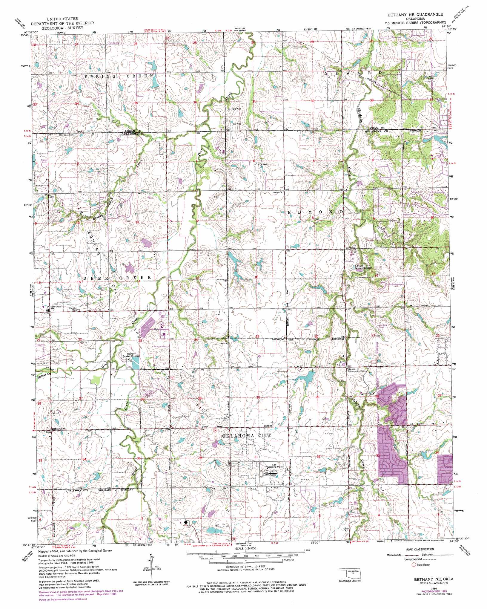
USGS Topo Quad 35097f5 - 1:24,000 scale
| Topo Map Name: | Bethany Ne |
| USGS Topo Quad ID: | 35097f5 |
| Print Size: | ca. 21 1/4" wide x 27" high |
| Southeast Coordinates: | 35.625° N latitude / 97.5° W longitude |
| Map Center Coordinates: | 35.6875° N latitude / 97.5625° W longitude |
| U.S. State: | OK |
| Filename: | o35097f5.jpg |
| Download Map JPG Image: | Bethany Ne topo map 1:24,000 scale |
| Map Type: | Topographic |
| Topo Series: | 7.5´ |
| Map Scale: | 1:24,000 |
| Source of Map Images: | United States Geological Survey (USGS) |
| Alternate Map Versions: |
Bethany NE OK 1966, updated 1967 Download PDF Buy paper map Bethany NE OK 1966, updated 1976 Download PDF Buy paper map Bethany NE OK 1966, updated 1983 Download PDF Buy paper map Bethany NE OK 2009 Download PDF Buy paper map Bethany NE OK 2012 Download PDF Buy paper map Bethany NE OK 2016 Download PDF Buy paper map |
1:24,000 Topo Quads surrounding Bethany Ne
Kingfisher Ne |
Crescent Nw |
Crescent |
Guthrie North |
Langston |
Kingfisher Se |
Cashion |
Navina |
Guthrie South |
Guthrie Se |
El Reno Ne |
Piedmont |
Bethany Ne |
Edmond |
Arcadia |
Richland |
Bethany |
Britton |
Spencer |
Jones |
Minco Ne |
Mustang |
Oklahoma City |
Midwest City |
Choctaw |
> Back to 35097e1 at 1:100,000 scale
> Back to 35096a1 at 1:250,000 scale
> Back to U.S. Topo Maps home
Bethany Ne topo map: Gazetteer
Bethany Ne: Airports
5B Ranch Airport elevation 328m 1076′Northwest Edmond Airport elevation 330m 1082′
Wakefield Strip elevation 322m 1056′
Bethany Ne: Dams
Deer Creek Farms Dam elevation 317m 1040′J-M Ranch Dam elevation 330m 1082′
Oknoname 083024 Dam elevation 319m 1046′
Oknoname 083043 Dam elevation 325m 1066′
Oknoname 083046 Dam elevation 317m 1040′
Oknoname 109019 Dam elevation 314m 1030′
Oknoname 16 Dam elevation 324m 1062′
Oknoname 17 Dam elevation 341m 1118′
Oknoname 19 Dam elevation 314m 1030′
Bethany Ne: Reservoirs
Deer Creek Farms Lake elevation 317m 1040′J-M Ranch Lake elevation 330m 1082′
Oknoname 083024 Reservoir elevation 319m 1046′
Oknoname 083043 Reservoir elevation 325m 1066′
Oknoname 083046 Reservoir elevation 317m 1040′
Oknoname 109019 Reservoir elevation 314m 1030′
Oknoname 16 Reservoir elevation 324m 1062′
Oknoname 17 Reservoir elevation 341m 1118′
Oknoname 19 Reservoir elevation 314m 1030′
Bethany Ne: Streams
Bloody Rush Creek elevation 305m 1000′Bluff Creek elevation 310m 1017′
Walnut Creek elevation 312m 1023′
Bethany Ne digital topo map on disk
Buy this Bethany Ne topo map showing relief, roads, GPS coordinates and other geographical features, as a high-resolution digital map file on DVD: