Democrat Hot Springs Topo Map California
To zoom in, hover over the map of Democrat Hot Springs
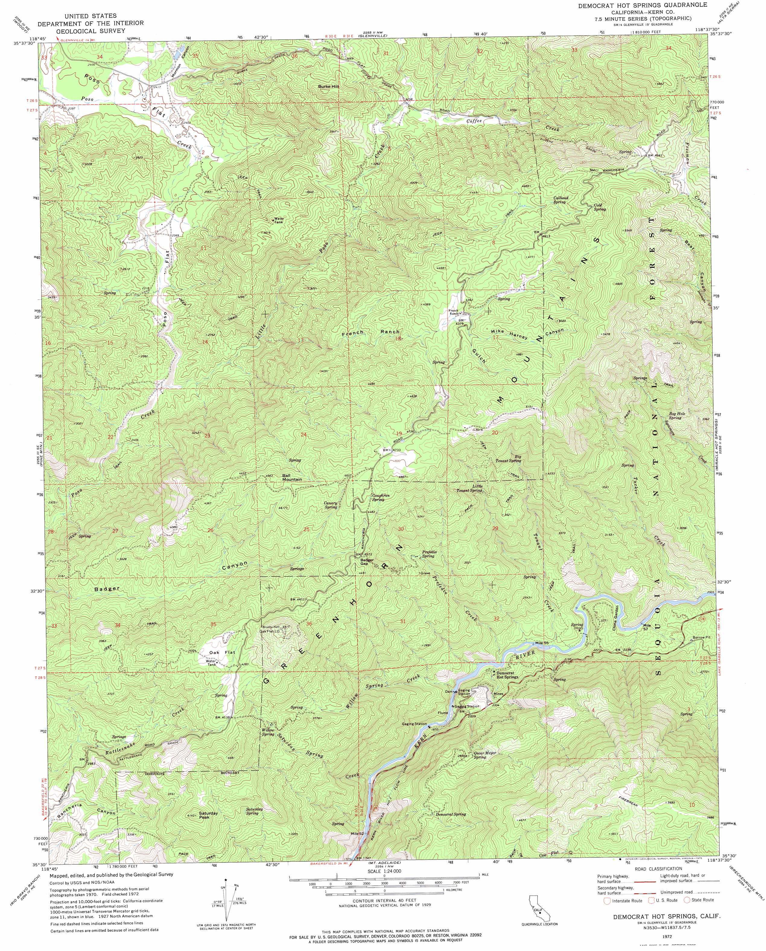
USGS Topo Quad 35118e6 - 1:24,000 scale
| Topo Map Name: | Democrat Hot Springs |
| USGS Topo Quad ID: | 35118e6 |
| Print Size: | ca. 21 1/4" wide x 27" high |
| Southeast Coordinates: | 35.5° N latitude / 118.625° W longitude |
| Map Center Coordinates: | 35.5625° N latitude / 118.6875° W longitude |
| U.S. State: | CA |
| Filename: | o35118e6.jpg |
| Download Map JPG Image: | Democrat Hot Springs topo map 1:24,000 scale |
| Map Type: | Topographic |
| Topo Series: | 7.5´ |
| Map Scale: | 1:24,000 |
| Source of Map Images: | United States Geological Survey (USGS) |
| Alternate Map Versions: |
Democrat Hot Springs CA 1972, updated 1975 Download PDF Buy paper map Democrat Hot Springs CA 1972, updated 1975 Download PDF Buy paper map Democrat Hot Springs CA 1972, updated 1994 Download PDF Buy paper map Democrat Hot Springs CA 1972, updated 1994 Download PDF Buy paper map Democrat Hot Springs CA 2012 Download PDF Buy paper map Democrat Hot Springs CA 2015 Download PDF Buy paper map |
| FStopo: | US Forest Service topo Democrat Hot Springs is available: Download FStopo PDF Download FStopo TIF |
1:24,000 Topo Quads surrounding Democrat Hot Springs
Quincy School |
White River |
Posey |
Tobias Peak |
Kernville |
Sand Canyon |
Woody |
Glennville |
Alta Sierra |
Lake Isabella North |
Knob Hill |
Pine Mountain |
Democrat Hot Springs |
Miracle Hot Springs |
Lake Isabella South |
Oil Center |
Rio Bravo Ranch |
Mount Adelaide |
Breckenridge Mountain |
Piute Peak |
Lamont |
Edison |
Bena |
Oiler Peak |
Loraine |
> Back to 35118e1 at 1:100,000 scale
> Back to 35118a1 at 1:250,000 scale
> Back to U.S. Topo Maps home
Democrat Hot Springs topo map: Gazetteer
Democrat Hot Springs: Dams
Diversion Number 1 104-002 Dam elevation 641m 2103′Democrat Hot Springs: Flats
China Garden elevation 602m 1975′Oak Flat elevation 1318m 4324′
Poso Flat elevation 736m 2414′
Democrat Hot Springs: Gaps
Badger Gap elevation 1303m 4274′Democrat Hot Springs: Springs
Big Tenant Spring elevation 1180m 3871′Callioud Spring elevation 1412m 4632′
Canary Spring elevation 1331m 4366′
Caughran Spring elevation 1404m 4606′
Cold Spring elevation 1487m 4878′
Democrat Spring elevation 964m 3162′
Hog Hole Spring elevation 993m 3257′
Little Tenant Spring elevation 1156m 3792′
Oscar Meyer Spring elevation 906m 2972′
Prefedio Spring elevation 1049m 3441′
Saturday Spring elevation 1074m 3523′
Willow Spring elevation 1154m 3786′
Democrat Hot Springs: Streams
Burke Creek elevation 721m 2365′Coffee Creek elevation 992m 3254′
Cow Flat Creek elevation 531m 1742′
Little Poso Creek elevation 692m 2270′
Prefedio Creek elevation 586m 1922′
Saturday Spring Creek elevation 565m 1853′
Tenant Creek elevation 590m 1935′
Tucker Creek elevation 610m 2001′
Willow Spring Creek elevation 591m 1938′
Democrat Hot Springs: Summits
Ball Mountain elevation 1404m 4606′Burke Hill elevation 1206m 3956′
Saturday Peak elevation 1260m 4133′
Democrat Hot Springs: Valleys
French Ranch Gulch elevation 742m 2434′Mike Harney Canyon elevation 1335m 4379′
Mormon Canyon elevation 732m 2401′
Democrat Hot Springs digital topo map on disk
Buy this Democrat Hot Springs topo map showing relief, roads, GPS coordinates and other geographical features, as a high-resolution digital map file on DVD:
Southern Sierra Nevada, California & Southern Nevada
Buy digital topo maps: Southern Sierra Nevada, California & Southern Nevada