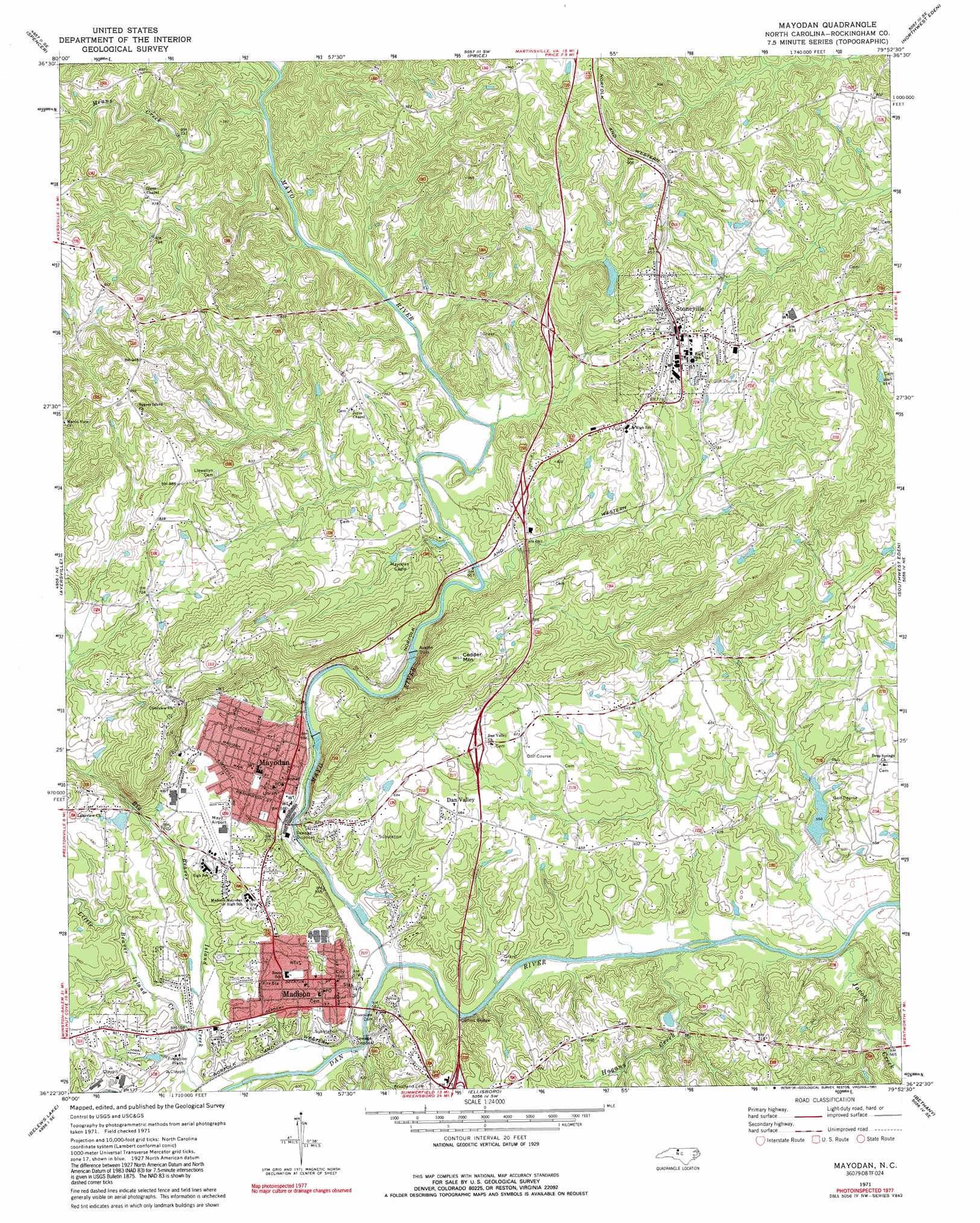
Mayodan Topo Map North Carolina
To zoom in, hover over the map of Mayodan
USGS Topo Quad 36079d8 - 1:24,000 scale
| Topo Map Name: | Mayodan |
| USGS Topo Quad ID: | 36079d8 |
| Print Size: | ca. 21 1/4" wide x 27" high |
| Southeast Coordinates: | 36.375° N latitude / 79.875° W longitude |
| Map Center Coordinates: | 36.4375° N latitude / 79.9375° W longitude |
| U.S. State: | NC |
| Filename: | o36079d8.jpg |
| Download Map JPG Image: | Mayodan topo map 1:24,000 scale |
| Map Type: | Topographic |
| Topo Series: | 7.5´ |
| Map Scale: | 1:24,000 |
| Source of Map Images: | United States Geological Survey (USGS) |
| Alternate Map Versions: |
Mayodan NC 1971, updated 1974 Download PDF Buy paper map Mayodan NC 1997, updated 2000 Download PDF Buy paper map Mayodan NC 2010 Download PDF Buy paper map Mayodan NC 2013 Download PDF Buy paper map Mayodan NC 2016 Download PDF Buy paper map |
1:24,000 Topo Quads surrounding Mayodan
Patrick Springs |
Sanville |
Martinsville West |
Martinsville East |
Axton |
Nettleridge |
Spencer |
Price |
Northwest Eden |
Northeast Eden |
Danbury |
Ayersville |
Mayodan |
Southwest Eden |
Southeast Eden |
Walnut Cove |
Belews Lake |
Ellisboro |
Bethany |
Reidsville |
Walkertown |
Belews Creek |
Summerfield |
Lake Brandt |
Browns Summit |
> Back to 36079a1 at 1:100,000 scale
> Back to 36078a1 at 1:250,000 scale
> Back to U.S. Topo Maps home
Mayodan topo map: Gazetteer
Mayodan: Airports
Mayo Airport elevation 202m 662′Mayodan: Bridges
Collins Bridge elevation 163m 534′Lindsays Bridge elevation 164m 538′
Madison Covered Bridge elevation 166m 544′
Mayodan: Dams
Avalon Dam elevation 184m 603′Grogan Estate Lake Dam elevation 190m 623′
Mayodan: Populated Places
Beaver Island elevation 290m 951′Dan Valley elevation 208m 682′
Deep Springs elevation 199m 652′
Deer Springs Country Club Estates elevation 183m 600′
Idol Park elevation 178m 583′
Madison elevation 187m 613′
Mayodan elevation 192m 629′
Mount View Estates elevation 210m 688′
Stone Mill Estates elevation 212m 695′
Stoneville elevation 251m 823′
Woodbine elevation 206m 675′
Mayodan: Post Offices
Madison Post Office elevation 181m 593′Mayodan Post Office elevation 193m 633′
Mayodan: Reservoirs
Grogan Estate Lake elevation 190m 623′Mayodan: Streams
Hogans Creek elevation 162m 531′Jacobs Creek elevation 163m 534′
Little Beaver Island Creek elevation 168m 551′
Mayo River elevation 164m 538′
Means Creek elevation 197m 646′
Pawpaw Creek elevation 198m 649′
Mayodan: Summits
Brush Mountain elevation 243m 797′Cedder Mountain elevation 303m 994′
Mayodan digital topo map on disk
Buy this Mayodan topo map showing relief, roads, GPS coordinates and other geographical features, as a high-resolution digital map file on DVD:
Western Virginia & Southern West Virginia
Buy digital topo maps: Western Virginia & Southern West Virginia