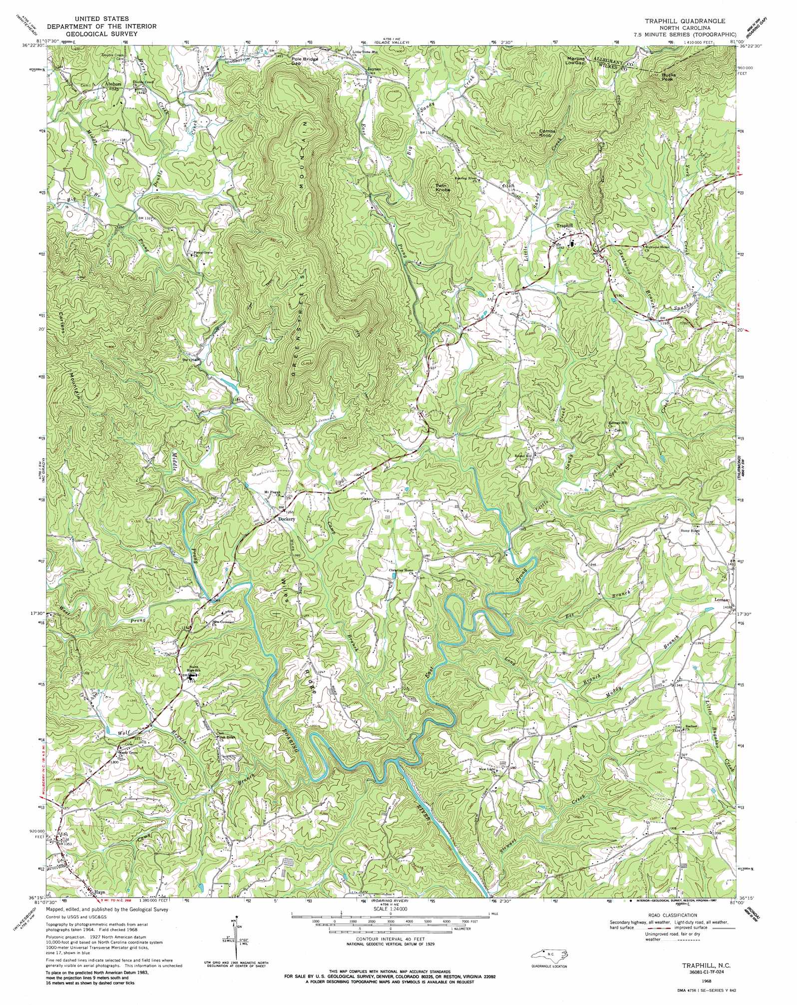
Traphill Topo Map North Carolina
To zoom in, hover over the map of Traphill
USGS Topo Quad 36081c1 - 1:24,000 scale
| Topo Map Name: | Traphill |
| USGS Topo Quad ID: | 36081c1 |
| Print Size: | ca. 21 1/4" wide x 27" high |
| Southeast Coordinates: | 36.25° N latitude / 81° W longitude |
| Map Center Coordinates: | 36.3125° N latitude / 81.0625° W longitude |
| U.S. State: | NC |
| Filename: | o36081c1.jpg |
| Download Map JPG Image: | Traphill topo map 1:24,000 scale |
| Map Type: | Topographic |
| Topo Series: | 7.5´ |
| Map Scale: | 1:24,000 |
| Source of Map Images: | United States Geological Survey (USGS) |
| Alternate Map Versions: |
Traphill NC 1968, updated 1971 Download PDF Buy paper map Traphill NC 1968, updated 1987 Download PDF Buy paper map Traphill NC 1968, updated 1987 Download PDF Buy paper map Traphill NC 2010 Download PDF Buy paper map Traphill NC 2013 Download PDF Buy paper map Traphill NC 2016 Download PDF Buy paper map |
1:24,000 Topo Quads surrounding Traphill
Mouth Of Wilson |
Sparta West |
Sparta East |
Cumberland Knob |
Lambsburg |
Laurel Springs |
Whitehead |
Glade Valley |
Roaring Gap |
Bottom |
Horse Gap |
Mcgrady |
Traphill |
Thurmond |
Elkin North |
Purlear |
Wilkesboro |
Roaring River |
Ronda |
Elkin South |
Boomer |
Moravian Falls |
Gilreath |
Osbornville |
Brooks Crossroads |
> Back to 36081a1 at 1:100,000 scale
> Back to 36080a1 at 1:250,000 scale
> Back to U.S. Topo Maps home
Traphill topo map: Gazetteer
Traphill: Gaps
Martins Low Gap elevation 545m 1788′Pole Bridge Gap elevation 464m 1522′
Traphill: Parks
Traphill Historic District elevation 425m 1394′Traphill: Populated Places
Abshers elevation 445m 1459′Brewers (historical) elevation 414m 1358′
Chuckle (historical) elevation 329m 1079′
Dockery elevation 385m 1263′
Joynes elevation 386m 1266′
Lomax elevation 428m 1404′
Moxley elevation 406m 1332′
Offer (historical) elevation 379m 1243′
Traphill elevation 396m 1299′
Zebra (historical) elevation 365m 1197′
Traphill: Ridges
Wiles Ridge elevation 377m 1236′Traphill: Streams
Bee Branch elevation 321m 1053′Big Branch elevation 394m 1292′
Big Sandy Creek elevation 372m 1220′
Camp Branch elevation 311m 1020′
Camp Branch elevation 307m 1007′
Cane Creek elevation 355m 1164′
Cheatwood Branch elevation 361m 1184′
Double Creek elevation 391m 1282′
East Prong Roaring River elevation 301m 987′
Harris Creek elevation 403m 1322′
Little Sandy Creek elevation 330m 1082′
Long Branch elevation 314m 1030′
Middle Prong Roaring River elevation 326m 1069′
Muddy Branch elevation 362m 1187′
Sparks Creek elevation 333m 1092′
Stewart Creek elevation 301m 987′
West Prong Roaring River elevation 326m 1069′
Wolf Branch elevation 344m 1128′
York Creek elevation 369m 1210′
Traphill: Summits
Bucks Peak elevation 716m 2349′Combs Knob elevation 580m 1902′
Greenstreets Mountain elevation 661m 2168′
Twin Knobs elevation 521m 1709′
Traphill digital topo map on disk
Buy this Traphill topo map showing relief, roads, GPS coordinates and other geographical features, as a high-resolution digital map file on DVD:
Western Virginia & Southern West Virginia
Buy digital topo maps: Western Virginia & Southern West Virginia