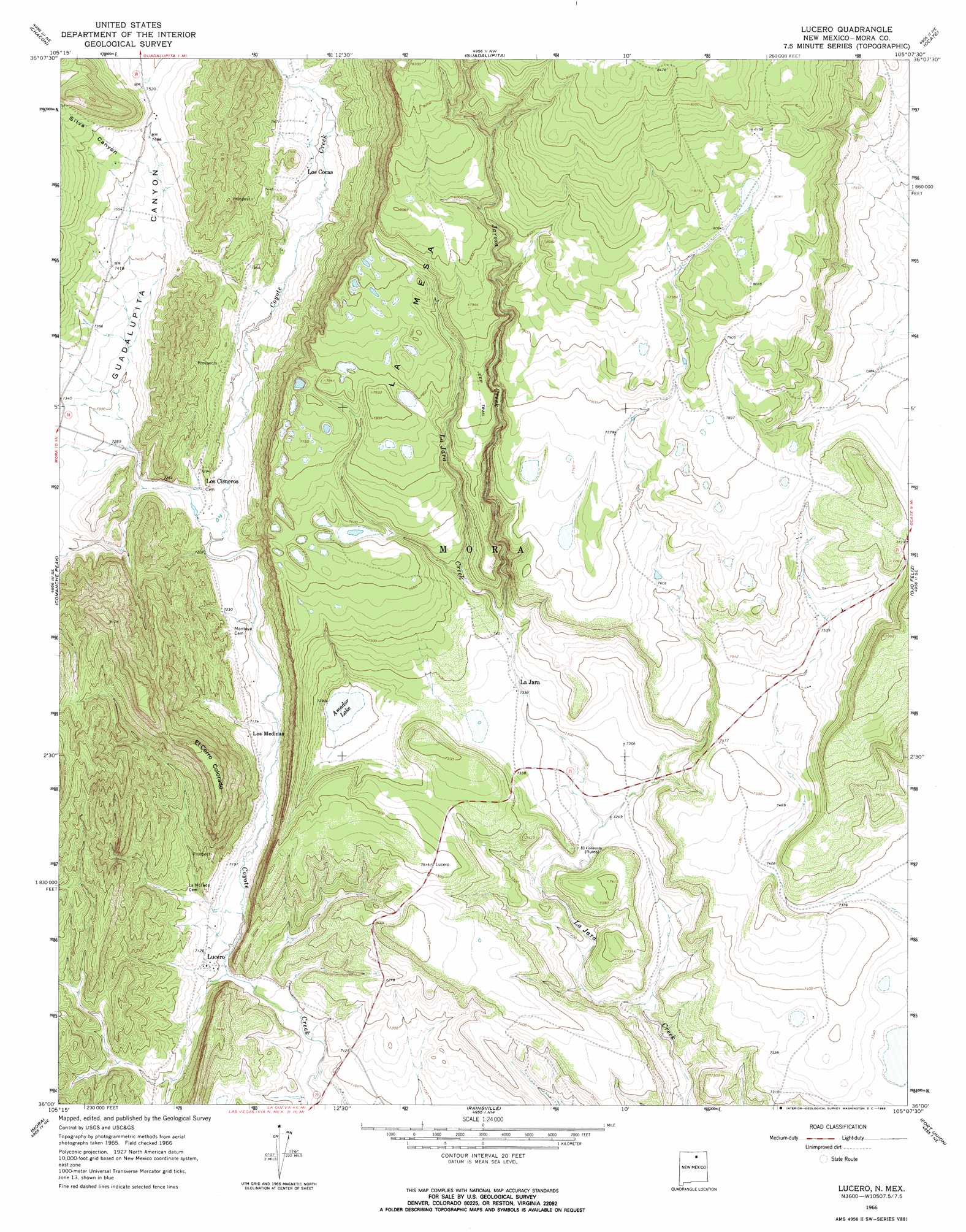
Lucero Topo Map New Mexico
To zoom in, hover over the map of Lucero
USGS Topo Quad 36105a2 - 1:24,000 scale
| Topo Map Name: | Lucero |
| USGS Topo Quad ID: | 36105a2 |
| Print Size: | ca. 21 1/4" wide x 27" high |
| Southeast Coordinates: | 36° N latitude / 105.125° W longitude |
| Map Center Coordinates: | 36.0625° N latitude / 105.1875° W longitude |
| U.S. State: | NM |
| Filename: | o36105a2.jpg |
| Download Map JPG Image: | Lucero topo map 1:24,000 scale |
| Map Type: | Topographic |
| Topo Series: | 7.5´ |
| Map Scale: | 1:24,000 |
| Source of Map Images: | United States Geological Survey (USGS) |
| Alternate Map Versions: |
Lucero NM 1966, updated 1968 Download PDF Buy paper map Lucero NM 1994, updated 1998 Download PDF Buy paper map Lucero NM 2010 Download PDF Buy paper map Lucero NM 2013 Download PDF Buy paper map Lucero NM 2017 Download PDF Buy paper map |
1:24,000 Topo Quads surrounding Lucero
Shady Brook |
Osha Mountain |
Agua Fria Peak |
White Peak |
Rayado |
Cerro Vista |
Chacon |
Guadalupita |
Ocate |
Mora Ranch |
Holman |
Comanche Peak |
Lucero |
Ojo Feliz |
Cerro Negro |
Gascon |
Mora |
Rainsville |
Fort Union |
Maxson Crater |
Rociada |
Sapello |
Lake Isabel |
Loma Parda |
Watrous |
> Back to 36105a1 at 1:100,000 scale
> Back to 36104a1 at 1:250,000 scale
> Back to U.S. Topo Maps home
Lucero topo map: Gazetteer
Lucero: Lakes
Amador Lake elevation 2222m 7290′Lucero: Populated Places
La Jara elevation 2237m 7339′Los Cisneros elevation 2214m 7263′
Los Cocas elevation 2264m 7427′
Los Medinas elevation 2199m 7214′
Lucero elevation 2171m 7122′
Lucero: Post Offices
La Jara Post Office elevation 2237m 7339′Lucero Post Office (historical) elevation 2171m 7122′
Lucero: Streams
Jarosa Creek elevation 2247m 7372′La Canada del Carro elevation 2195m 7201′
Lucero: Summits
El Cerro Colorado elevation 2411m 7910′Lucero: Valleys
Guadalupita Canyon elevation 2219m 7280′Silva Canyon elevation 2286m 7500′
Lucero digital topo map on disk
Buy this Lucero topo map showing relief, roads, GPS coordinates and other geographical features, as a high-resolution digital map file on DVD: