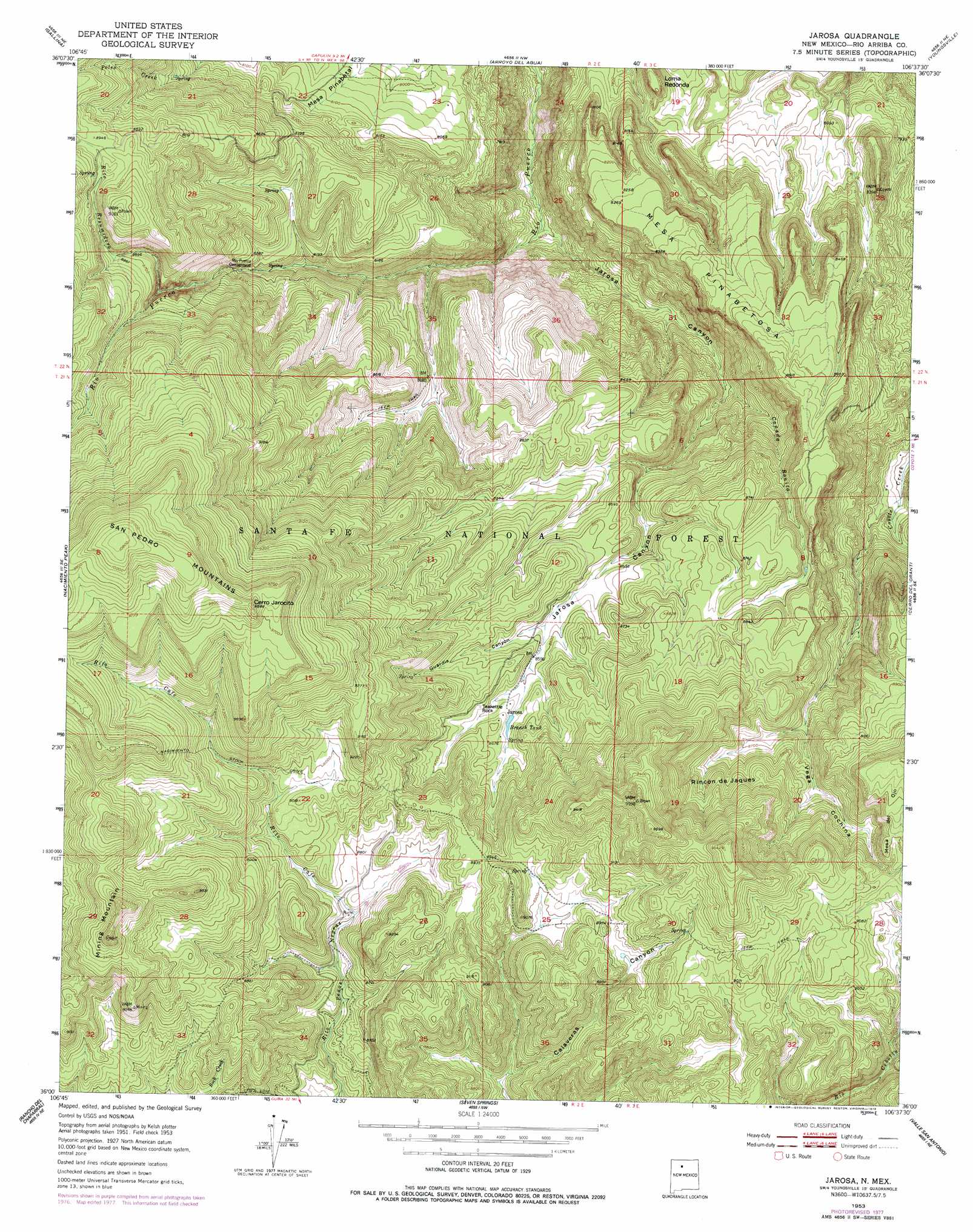
Jarosa Topo Map New Mexico
To zoom in, hover over the map of Jarosa
USGS Topo Quad 36106a6 - 1:24,000 scale
| Topo Map Name: | Jarosa |
| USGS Topo Quad ID: | 36106a6 |
| Print Size: | ca. 21 1/4" wide x 27" high |
| Southeast Coordinates: | 36° N latitude / 106.625° W longitude |
| Map Center Coordinates: | 36.0625° N latitude / 106.6875° W longitude |
| U.S. State: | NM |
| Filename: | o36106a6.jpg |
| Download Map JPG Image: | Jarosa topo map 1:24,000 scale |
| Map Type: | Topographic |
| Topo Series: | 7.5´ |
| Map Scale: | 1:24,000 |
| Source of Map Images: | United States Geological Survey (USGS) |
| Alternate Map Versions: |
Jarosa NM 1953, updated 1955 Download PDF Buy paper map Jarosa NM 1953, updated 1967 Download PDF Buy paper map Jarosa NM 1953, updated 1979 Download PDF Buy paper map Jarosa NM 2002, updated 2003 Download PDF Buy paper map Jarosa NM 2011 Download PDF Buy paper map Jarosa NM 2013 Download PDF Buy paper map Jarosa NM 2017 Download PDF Buy paper map |
| FStopo: | US Forest Service topo Jarosa is available: Download FStopo PDF Download FStopo TIF |
1:24,000 Topo Quads surrounding Jarosa
Laguna Gurule |
French Mesa |
Laguna Peak |
Echo Amphitheater |
Ghost Ranch |
Regina |
Gallina |
Arroyo Del Agua |
Youngsville |
Canones |
Cuba |
Nacimiento Peak |
Jarosa |
Cerro Del Grant |
Polvadera Peak |
San Pablo |
Rancho Del Chaparral |
Seven Springs |
Valle San Antonio |
Valle Toledo |
La Ventana |
San Miguel Mountain |
Jemez Springs |
Redondo Peak |
Bland |
> Back to 36106a1 at 1:100,000 scale
> Back to 36106a1 at 1:250,000 scale
> Back to U.S. Topo Maps home
Jarosa topo map: Gazetteer
Jarosa: Arches
Teakettle Rock elevation 2645m 8677′Jarosa: Basins
Rincon de Jaques elevation 2699m 8854′Jarosa: Benches
Mesa Pinabetosa elevation 2576m 8451′Jarosa: Mines
Jarossa Mine elevation 2718m 8917′Lease Pit elevation 2601m 8533′
Saint Jude elevation 2701m 8861′
Jarosa: Populated Places
Jarosa elevation 2640m 8661′Jarosa: Reservoirs
Aranda Tank elevation 2619m 8592′Bonita Tank elevation 2646m 8681′
Branch Tank elevation 2631m 8631′
Jarosito Trick Tnak elevation 2750m 9022′
Martinez Tanks elevation 2620m 8595′
Mesa Ojitos Trick Tank elevation 2434m 7985′
Pinabetosa Trick Tank elevation 2528m 8293′
Twin Ponds Tank elevation 2726m 8943′
Jarosa: Springs
Aranda Spring elevation 2606m 8549′Bonito Spring elevation 2521m 8270′
Campground Spring elevation 2466m 8090′
Canada Ojitos elevation 2596m 8517′
Cerro Spring elevation 2917m 9570′
Cochina Spring elevation 2658m 8720′
Cochina Spring elevation 2720m 8923′
Diego Spring elevation 2762m 9061′
Dunlap Spring elevation 2724m 8937′
Guardia Spring elevation 2682m 8799′
Jarosito Spring elevation 2767m 9078′
Juan Spring elevation 2778m 9114′
Luterio Spring elevation 2831m 9288′
Nester Spring elevation 2586m 8484′
Nick Spring elevation 2634m 8641′
Pablo Spring elevation 2740m 8989′
Pedro Spring elevation 2761m 9058′
Rincon Spring elevation 2545m 8349′
Jarosa: Streams
Cañada Bonita elevation 2402m 7880′Rito Cafe elevation 2662m 8733′
Rito Redondo elevation 2711m 8894′
Rito Resumidero elevation 2580m 8464′
Jarosa: Summits
Cerro Jarocito elevation 2993m 9819′Loma Redonda elevation 2459m 8067′
Mining Mountain elevation 2927m 9603′
Jarosa: Valleys
Guardia Canyon elevation 2614m 8576′Jarosa Canyon elevation 2252m 7388′
Vega Cochina elevation 2416m 7926′
Jarosa digital topo map on disk
Buy this Jarosa topo map showing relief, roads, GPS coordinates and other geographical features, as a high-resolution digital map file on DVD: