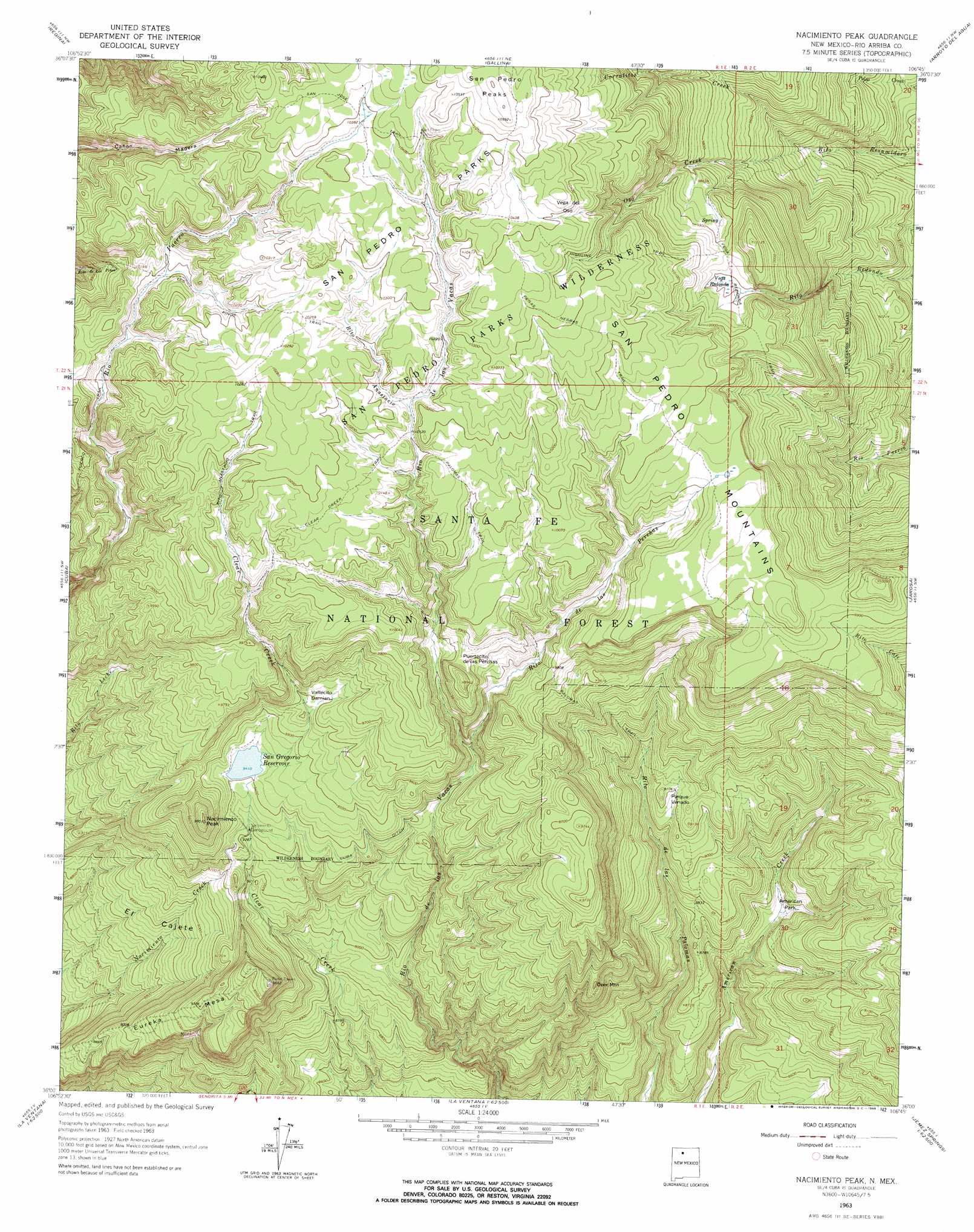
Nacimiento Peak Topo Map New Mexico
To zoom in, hover over the map of Nacimiento Peak
USGS Topo Quad 36106a7 - 1:24,000 scale
| Topo Map Name: | Nacimiento Peak |
| USGS Topo Quad ID: | 36106a7 |
| Print Size: | ca. 21 1/4" wide x 27" high |
| Southeast Coordinates: | 36° N latitude / 106.75° W longitude |
| Map Center Coordinates: | 36.0625° N latitude / 106.8125° W longitude |
| U.S. State: | NM |
| Filename: | o36106a7.jpg |
| Download Map JPG Image: | Nacimiento Peak topo map 1:24,000 scale |
| Map Type: | Topographic |
| Topo Series: | 7.5´ |
| Map Scale: | 1:24,000 |
| Source of Map Images: | United States Geological Survey (USGS) |
| Alternate Map Versions: |
Nacimiento Peak NM 1963, updated 1966 Download PDF Buy paper map Nacimiento Peak NM 1963, updated 1972 Download PDF Buy paper map Nacimiento Peak NM 2002, updated 2003 Download PDF Buy paper map Nacimiento Peak NM 2011 Download PDF Buy paper map Nacimiento Peak NM 2013 Download PDF Buy paper map |
| FStopo: | US Forest Service topo Nacimiento Peak is available: Download FStopo PDF Download FStopo TIF |
1:24,000 Topo Quads surrounding Nacimiento Peak
Lindrith |
Laguna Gurule |
French Mesa |
Laguna Peak |
Echo Amphitheater |
Five Lakes Canyon Ne |
Regina |
Gallina |
Arroyo Del Agua |
Youngsville |
Arroyo Chijuillita |
Cuba |
Nacimiento Peak |
Jarosa |
Cerro Del Grant |
Mesa Portales |
San Pablo |
Rancho Del Chaparral |
Seven Springs |
Valle San Antonio |
Headcut Reservoir |
La Ventana |
San Miguel Mountain |
Jemez Springs |
Redondo Peak |
> Back to 36106a1 at 1:100,000 scale
> Back to 36106a1 at 1:250,000 scale
> Back to U.S. Topo Maps home
Nacimiento Peak topo map: Gazetteer
Nacimiento Peak: Areas
El Cajete elevation 2710m 8891′San Pedro Parks elevation 3151m 10337′
Vega del Oso elevation 3172m 10406′
Nacimiento Peak: Basins
Vallecito Damian elevation 2929m 9609′Nacimiento Peak: Canals
Cuba Ditch elevation 2968m 9737′Nacimiento Peak: Dams
San Gregorio Reservoir Dam elevation 2869m 9412′Nacimiento Peak: Flats
American Park elevation 2638m 8654′Parque Venado elevation 2768m 9081′
Nacimiento Peak: Gaps
Puertecito de las Perchas elevation 2998m 9835′Nacimiento Peak: Ranges
San Pedro Mountains elevation 3141m 10305′San Pedro Peaks elevation 3232m 10603′
Nacimiento Peak: Reservoirs
San Gregorio Reservoir elevation 2869m 9412′Nacimiento Peak: Streams
Oso Creek elevation 2825m 9268′Rito Anastacio elevation 3089m 10134′
Rito de las Perchas elevation 2898m 9507′
Nacimiento Peak: Summits
Deer Mountain elevation 2827m 9274′Eureka Mesa elevation 2925m 9596′
Nacimiento Peak elevation 2973m 9753′
Nacimiento Peak: Swamps
Vega Redonda elevation 3018m 9901′Nacimiento Peak: Trails
Clear Creek Trail elevation 3103m 10180′Highline Trail elevation 3127m 10259′
Los Pinos Trail elevation 3093m 10147′
Palomas Trail elevation 2964m 9724′
Peñas Negras Trail elevation 3091m 10141′
Perchas Trail elevation 2998m 9835′
Redonda Trail elevation 3051m 10009′
Nacimiento Peak digital topo map on disk
Buy this Nacimiento Peak topo map showing relief, roads, GPS coordinates and other geographical features, as a high-resolution digital map file on DVD: