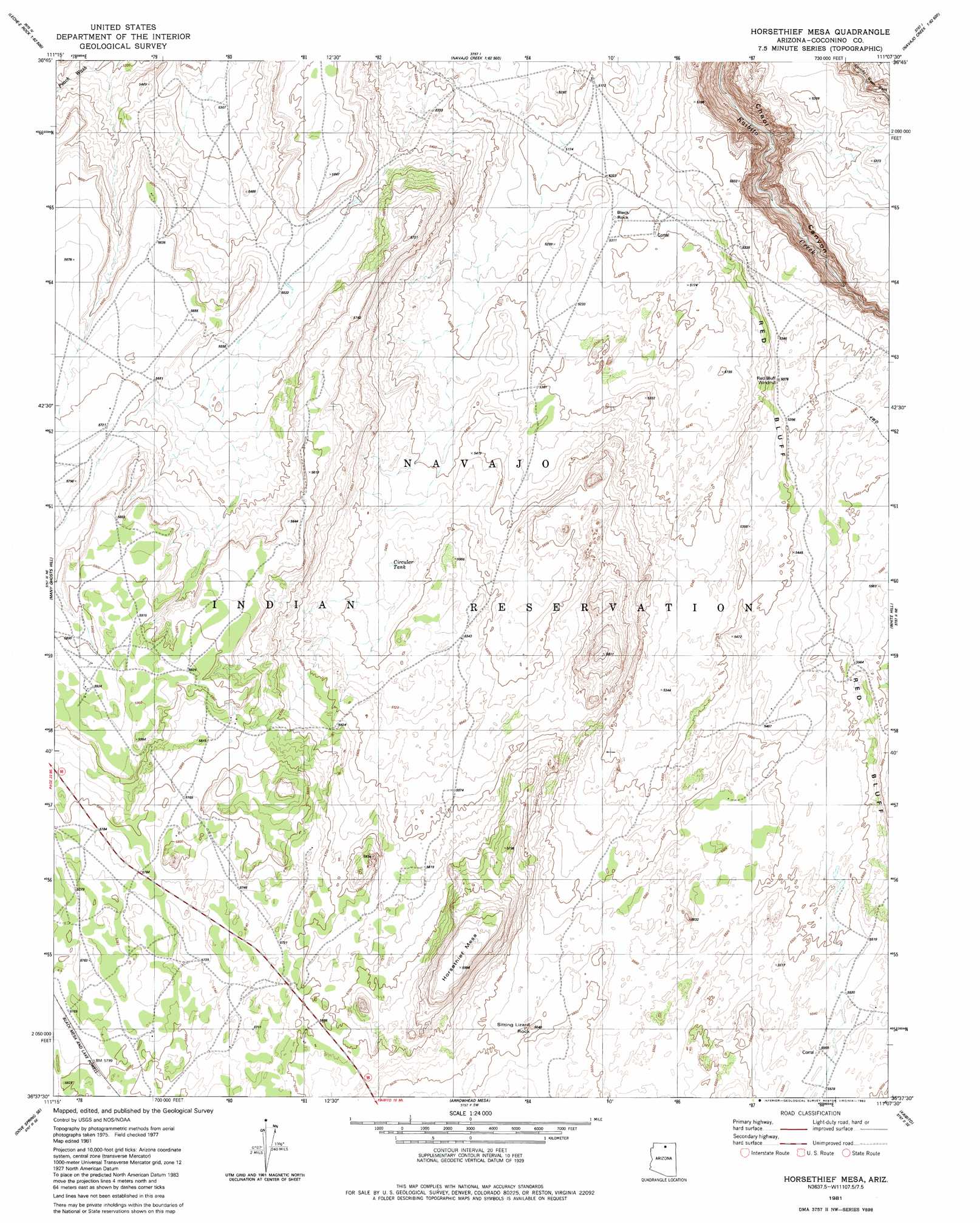
Horsethief Mesa Topo Map Arizona
To zoom in, hover over the map of Horsethief Mesa
USGS Topo Quad 36111f2 - 1:24,000 scale
| Topo Map Name: | Horsethief Mesa |
| USGS Topo Quad ID: | 36111f2 |
| Print Size: | ca. 21 1/4" wide x 27" high |
| Southeast Coordinates: | 36.625° N latitude / 111.125° W longitude |
| Map Center Coordinates: | 36.6875° N latitude / 111.1875° W longitude |
| U.S. State: | AZ |
| Filename: | o36111f2.jpg |
| Download Map JPG Image: | Horsethief Mesa topo map 1:24,000 scale |
| Map Type: | Topographic |
| Topo Series: | 7.5´ |
| Map Scale: | 1:24,000 |
| Source of Map Images: | United States Geological Survey (USGS) |
| Alternate Map Versions: |
Horsethief Mesa AZ 1981, updated 1982 Download PDF Buy paper map Horsethief Mesa AZ 2011 Download PDF Buy paper map Horsethief Mesa AZ 2014 Download PDF Buy paper map |
1:24,000 Topo Quads surrounding Horsethief Mesa
Page |
Wild Horse Mesa |
Face Canyon |
West Canyon Creek |
Chaiyahi Flat |
White Dome |
Leche-E Rock |
Cedar Tree Bench |
Tse Esgizii |
Chaiyahi Rim Sw |
Dead Monkey Ridge |
Many Ghosts Hill |
Horsethief Mesa |
White Hill |
Two Red Mesas |
Dove Spring |
Dove Spring Se |
Arrowhead Mesa |
Kaibito |
Square Butte |
Toh Bih Nosteny |
Sitting Coyote Hill |
Preston Mesa North |
Big Whisker Well |
White Mesa Arch |
> Back to 36111e1 at 1:100,000 scale
> Back to 36110a1 at 1:250,000 scale
> Back to U.S. Topo Maps home
Horsethief Mesa topo map: Gazetteer
Horsethief Mesa: Arches
Sitting Lizard Arch elevation 1708m 5603′Horsethief Mesa: Cliffs
Red Bluff elevation 1681m 5515′Horsethief Mesa: Pillars
Black Rock elevation 1592m 5223′Sitting Lizard Rock elevation 1716m 5629′
Horsethief Mesa: Reservoirs
Circular Tank elevation 1661m 5449′Horsethief Mesa: Summits
Horse Thief Mesa elevation 1823m 5980′Horsethief Mesa: Wells
Red Bluff Windmill elevation 1623m 5324′Horsethief Mesa digital topo map on disk
Buy this Horsethief Mesa topo map showing relief, roads, GPS coordinates and other geographical features, as a high-resolution digital map file on DVD: