Page Topo Map Arizona
To zoom in, hover over the map of Page
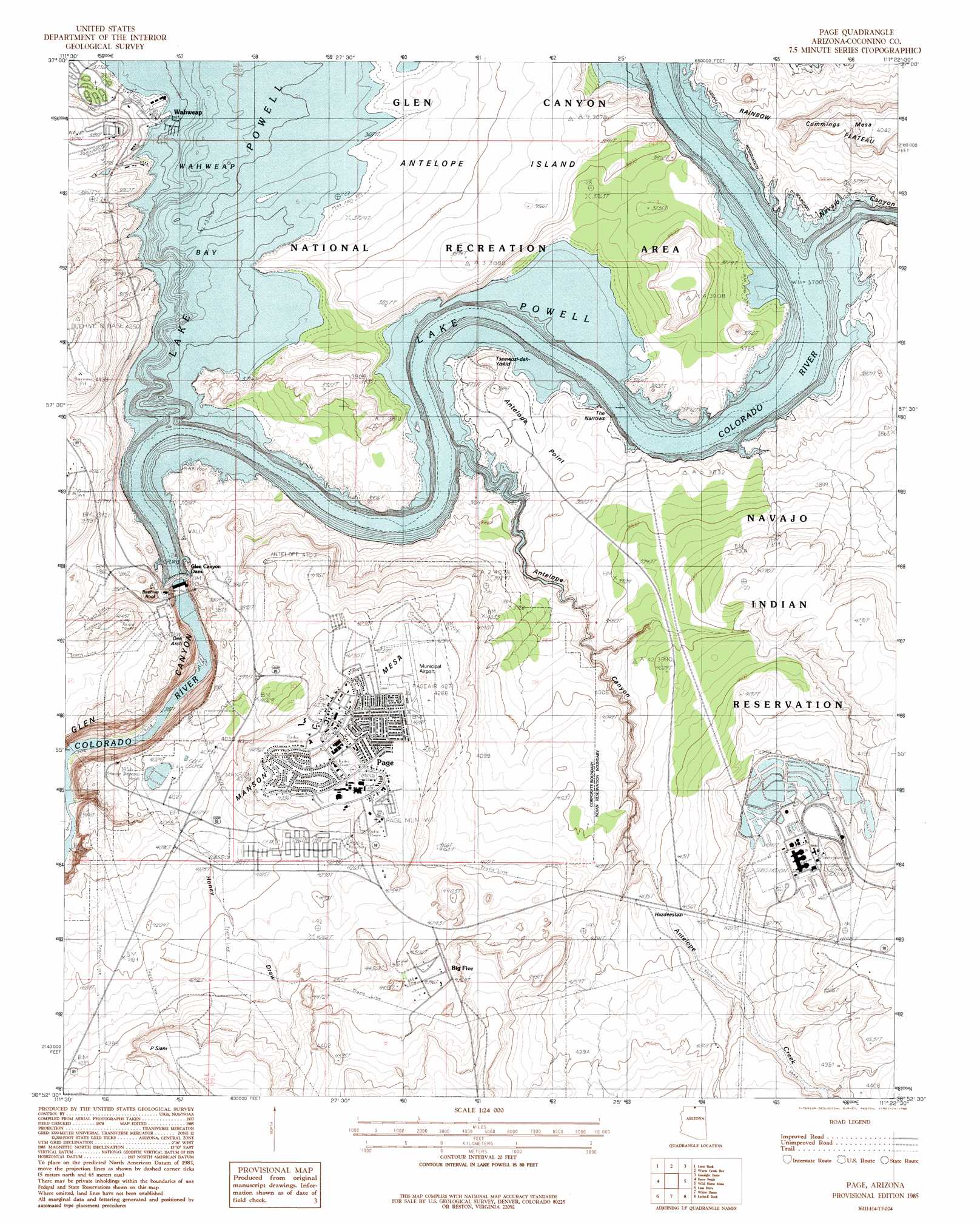
USGS Topo Quad 36111h4 - 1:24,000 scale
| Topo Map Name: | Page |
| USGS Topo Quad ID: | 36111h4 |
| Print Size: | ca. 21 1/4" wide x 27" high |
| Southeast Coordinates: | 36.875° N latitude / 111.375° W longitude |
| Map Center Coordinates: | 36.9375° N latitude / 111.4375° W longitude |
| U.S. State: | AZ |
| Filename: | o36111h4.jpg |
| Download Map JPG Image: | Page topo map 1:24,000 scale |
| Map Type: | Topographic |
| Topo Series: | 7.5´ |
| Map Scale: | 1:24,000 |
| Source of Map Images: | United States Geological Survey (USGS) |
| Alternate Map Versions: |
Page AZ 1985, updated 1986 Download PDF Buy paper map Page AZ 1985, updated 1986 Download PDF Buy paper map Page AZ 2011 Download PDF Buy paper map Page AZ 2011 Download PDF Buy paper map Page AZ 2014 Download PDF Buy paper map |
1:24,000 Topo Quads surrounding Page
Nipple Butte |
Tibbet Bench |
Smoky Hollow |
Sit Down Bench |
Mazuki Point |
Glen Canyon City |
Lone Rock |
Warm Creek Bay |
Gunsight Butte |
Gregory Butte |
Water Pockets |
Ferry Swale |
Page |
Wild Horse Mesa |
Face Canyon |
Navajo Bridge |
Lees Ferry |
White Dome |
Leche-E Rock |
Cedar Tree Bench |
Bitter Springs |
Explosive Rock |
Dead Monkey Ridge |
Many Ghosts Hill |
Horsethief Mesa |
> Back to 36111e1 at 1:100,000 scale
> Back to 36110a1 at 1:250,000 scale
> Back to U.S. Topo Maps home
Page topo map: Gazetteer
Page: Airports
Emergency Medical Heliport elevation 1309m 4294′Page Municipal Airport elevation 1299m 4261′
Wahweap Airport elevation 1183m 3881′
Page: Dams
Glen Canyon Dam elevation 1106m 3628′Page: Islands
Antelope Island elevation 1173m 3848′Page: Parks
Jack Doland Field elevation 1336m 4383′John C Page Park elevation 1328m 4356′
Page: Pillars
Beehive Rock elevation 1244m 4081′Sentinel Rock elevation 0m 0′
Page: Populated Places
Page elevation 1326m 4350′Wahweap elevation 1129m 3704′
Page: Reservoirs
Lake Powell elevation 963m 3159′Page: Streams
Antelope Creek elevation 1129m 3704′Navajo Creek elevation 1129m 3704′
Page: Summits
Cummings Mesa elevation 1226m 4022′Manson Mesa elevation 1332m 4370′
Page: Valleys
Antelope Canyon elevation 1129m 3704′Navajo Canyon elevation 1129m 3704′
Page digital topo map on disk
Buy this Page topo map showing relief, roads, GPS coordinates and other geographical features, as a high-resolution digital map file on DVD: