Devils Hole Topo Map Nevada
To zoom in, hover over the map of Devils Hole
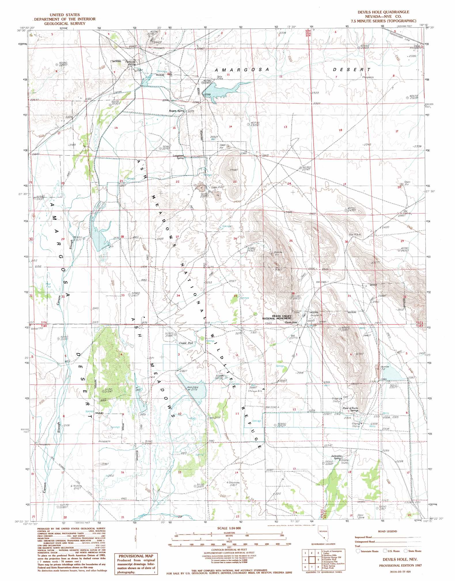
USGS Topo Quad 36116d3 - 1:24,000 scale
| Topo Map Name: | Devils Hole |
| USGS Topo Quad ID: | 36116d3 |
| Print Size: | ca. 21 1/4" wide x 27" high |
| Southeast Coordinates: | 36.375° N latitude / 116.25° W longitude |
| Map Center Coordinates: | 36.4375° N latitude / 116.3125° W longitude |
| U.S. State: | NV |
| Filename: | o36116d3.jpg |
| Download Map JPG Image: | Devils Hole topo map 1:24,000 scale |
| Map Type: | Topographic |
| Topo Series: | 7.5´ |
| Map Scale: | 1:24,000 |
| Source of Map Images: | United States Geological Survey (USGS) |
| Alternate Map Versions: |
Devils Hole NV 1987, updated 1987 Download PDF Buy paper map Devils Hole NV 2012 Download PDF Buy paper map Devils Hole NV 2015 Download PDF Buy paper map |
1:24,000 Topo Quads surrounding Devils Hole
Big Dune |
Lathrop Wells |
Striped Hills |
Specter Range Nw |
Camp Desert Rock |
Leeland |
South Of Amargosa Valley |
Skeleton Hills |
Specter Range Sw |
Point Of Rocks |
East Of Echo Canyon |
Franklin Well |
Devils Hole |
Amargosa Flat |
Mount Schader |
East Of Ryan |
Death Valley Junction |
Bole Spring |
High Peak |
Last Chance Range |
Greenwater Canyon |
West Of Eagle Mountain |
Eagle Mountain |
Stewart Valley |
Sixmile Spring |
> Back to 36116a1 at 1:100,000 scale
> Back to 36116a1 at 1:250,000 scale
> Back to U.S. Topo Maps home
Devils Hole topo map: Gazetteer
Devils Hole: Basins
Ash Meadows elevation 655m 2148′Devils Hole: Dams
Crystal Lake Dam elevation 665m 2181′Dam C elevation 720m 2362′
Lake Number One Dam elevation 697m 2286′
Little Lake Dam elevation 653m 2142′
Devils Hole: Parks
Ash Meadows National Wildlife Refuge elevation 683m 2240′Devils Hole: Reservoirs
Crystal Reservoir elevation 665m 2181′Dam C Reservoir elevation 720m 2362′
Horseshoe Reservoir elevation 658m 2158′
Lake Number One elevation 697m 2286′
Peterson Reservoir elevation 662m 2171′
Devils Hole: Springs
Big Spring elevation 666m 2185′Bradford Springs elevation 683m 2240′
Button Springs elevation 715m 2345′
Crystal Pool elevation 671m 2201′
Davis Ranch Spring elevation 683m 2240′
Devils Hole elevation 739m 2424′
Fairbanks Spring elevation 689m 2260′
Forest Spring elevation 700m 2296′
Indian Garden Spring elevation 727m 2385′
Indian Rock Spring elevation 703m 2306′
Indian Spring elevation 686m 2250′
Jackrabbit Spring elevation 693m 2273′
Longstreet Spring elevation 705m 2312′
Main Spring elevation 730m 2395′
Marsh Spring elevation 687m 2253′
Mary Scott Spring elevation 720m 2362′
Mexican Spring elevation 705m 2312′
Parent Springs elevation 736m 2414′
Point of Rocks Springs elevation 708m 2322′
Rogers Spring elevation 694m 2276′
School Spring elevation 710m 2329′
Skruggs Spring elevation 707m 2319′
Soda Spring elevation 690m 2263′
Tubbs Spring elevation 696m 2283′
Devils Hole: Swamps
Carson Marsh elevation 675m 2214′Crystal Marsh elevation 653m 2142′
Horseshoe Marsh elevation 658m 2158′
Devils Hole: Wells
D H Well elevation 735m 2411′Purgatory Spring Well elevation 711m 2332′
Devils Hole digital topo map on disk
Buy this Devils Hole topo map showing relief, roads, GPS coordinates and other geographical features, as a high-resolution digital map file on DVD:
Southern Sierra Nevada, California & Southern Nevada
Buy digital topo maps: Southern Sierra Nevada, California & Southern Nevada