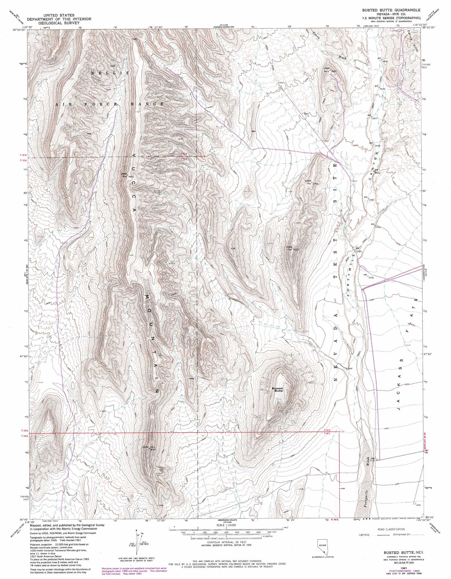
Busted Butte Topo Map Nevada
To zoom in, hover over the map of Busted Butte
USGS Topo Quad 36116g4 - 1:24,000 scale
| Topo Map Name: | Busted Butte |
| USGS Topo Quad ID: | 36116g4 |
| Print Size: | ca. 21 1/4" wide x 27" high |
| Southeast Coordinates: | 36.75° N latitude / 116.375° W longitude |
| Map Center Coordinates: | 36.8125° N latitude / 116.4375° W longitude |
| U.S. State: | NV |
| Filename: | o36116g4.jpg |
| Download Map JPG Image: | Busted Butte topo map 1:24,000 scale |
| Map Type: | Topographic |
| Topo Series: | 7.5´ |
| Map Scale: | 1:24,000 |
| Source of Map Images: | United States Geological Survey (USGS) |
| Alternate Map Versions: |
Topopah Spring SW NV 1961, updated 1962 Download PDF Buy paper map Topopah Spring SW NV 1961, updated 1975 Download PDF Buy paper map Busted Butte NV 1961, updated 1983 Download PDF Buy paper map Busted Butte NV 1961, updated 1984 Download PDF Buy paper map Busted Butte NV 1961, updated 1985 Download PDF Buy paper map Busted Butte NV 1961, updated 1986 Download PDF Buy paper map |
1:24,000 Topo Quads surrounding Busted Butte
Thirsty Canyon Sw |
Thirsty Canyon Se |
Timber Mountain |
Buckboard Mesa |
Tippipah Spring |
Beatty Mountain |
East Of Beatty Mountain |
Topopah Springs Nw |
Topopah Spring |
Mine Mountain |
Carrara Canyon |
Crater Flat |
Busted Butte |
Jackass Flats |
Skull Mountain |
Ashton |
Big Dune |
Lathrop Wells |
Striped Hills |
Specter Range Nw |
Lees Camp |
Leeland |
South Of Amargosa Valley |
Skeleton Hills |
Specter Range Sw |
> Back to 36116e1 at 1:100,000 scale
> Back to 36116a1 at 1:250,000 scale
> Back to U.S. Topo Maps home
Busted Butte topo map: Gazetteer
Busted Butte: Gaps
Ambush Pass elevation 1102m 3615′Busted Butte: Reservoirs
Iron Tank elevation 953m 3126′Busted Butte: Ridges
Boundary Ridge elevation 1204m 3950′Bow Ridge elevation 1140m 3740′
Creosote Ridge elevation 966m 3169′
False Crest elevation 1281m 4202′
Fran Ridge elevation 1071m 3513′
Iron Ridge elevation 1177m 3861′
Knotted Ridge elevation 1519m 4983′
Quail Ridge elevation 1304m 4278′
Stairs Ridge elevation 1349m 4425′
Yucca Crest elevation 1466m 4809′
Busted Butte: Streams
Pagany Wash elevation 1133m 3717′Sever Wash elevation 1007m 3303′
Teacup Wash elevation 1274m 4179′
Yucca Wash elevation 1079m 3540′
Busted Butte: Summits
Alice Point elevation 1212m 3976′Busted Butte elevation 1295m 4248′
Little Prow elevation 1466m 4809′
Plug Hill elevation 1223m 4012′
Busted Butte: Valleys
Dune Wash elevation 957m 3139′Fortymile Canyon elevation 962m 3156′
Sear Valley elevation 1037m 3402′
Solitario Canyon elevation 1193m 3914′
Busted Butte: Wells
Well J-Twelve elevation 953m 3126′Busted Butte digital topo map on disk
Buy this Busted Butte topo map showing relief, roads, GPS coordinates and other geographical features, as a high-resolution digital map file on DVD:
Southern Sierra Nevada, California & Southern Nevada
Buy digital topo maps: Southern Sierra Nevada, California & Southern Nevada