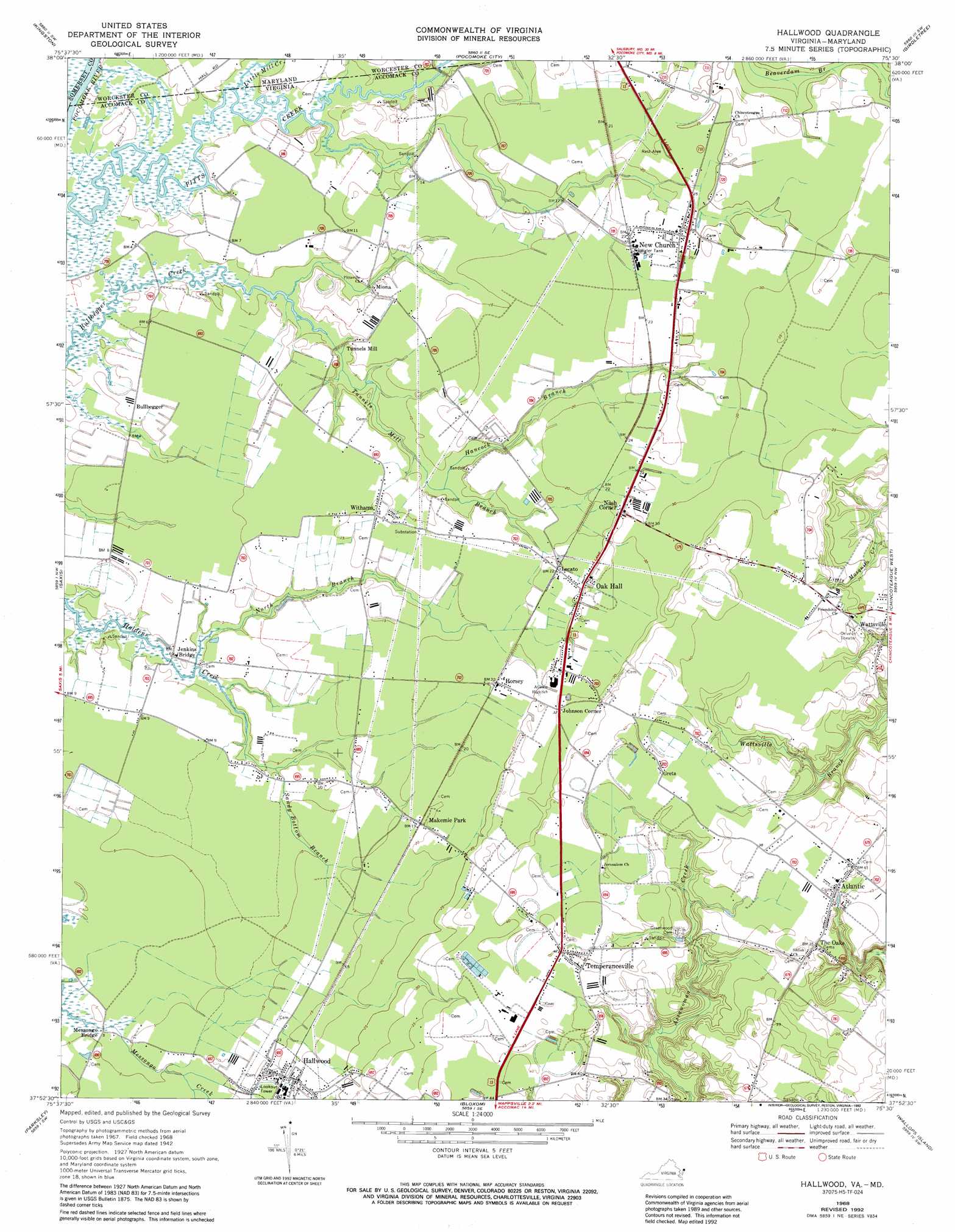
Hallwood Topo Map Virginia
To zoom in, hover over the map of Hallwood
USGS Topo Quad 37075h5 - 1:24,000 scale
| Topo Map Name: | Hallwood |
| USGS Topo Quad ID: | 37075h5 |
| Print Size: | ca. 21 1/4" wide x 27" high |
| Southeast Coordinates: | 37.875° N latitude / 75.5° W longitude |
| Map Center Coordinates: | 37.9375° N latitude / 75.5625° W longitude |
| U.S. States: | VA, MD |
| Filename: | o37075h5.jpg |
| Download Map JPG Image: | Hallwood topo map 1:24,000 scale |
| Map Type: | Topographic |
| Topo Series: | 7.5´ |
| Map Scale: | 1:24,000 |
| Source of Map Images: | United States Geological Survey (USGS) |
| Alternate Map Versions: |
Hallwood VA 1953 Download PDF Buy paper map Hallwood VA 1968, updated 1971 Download PDF Buy paper map Hallwood VA 1968, updated 1983 Download PDF Buy paper map Hallwood VA 1968, updated 1991 Download PDF Buy paper map Hallwood VA 1968, updated 1992 Download PDF Buy paper map Hallwood VA 2011 Download PDF Buy paper map Hallwood VA 2013 Download PDF Buy paper map Hallwood VA 2016 Download PDF Buy paper map |
1:24,000 Topo Quads surrounding Hallwood
Monie |
Princess Anne |
Dividing Creek |
Snow Hill |
Public Landing |
Marion |
Kingston |
Pocomoke City |
Girdletree |
Boxiron |
Crisfield |
Saxis |
Hallwood |
Chincoteague West |
Chincoteague East |
Chesconessex |
Parksley |
Bloxom |
Wallops Island |
|
Pungoteague |
Accomac |
Metompkin Inlet |
> Back to 37075e1 at 1:100,000 scale
> Back to 37074a1 at 1:250,000 scale
> Back to U.S. Topo Maps home
Hallwood topo map: Gazetteer
Hallwood: Airports
High Hopes Airport elevation 2m 6′Sawyer Stolport elevation 2m 6′
Taylor Airport elevation 12m 39′
Hallwood: Populated Places
Atlantic elevation 11m 36′Bullbegger elevation 1m 3′
Greta (historical) elevation 11m 36′
Hallwood elevation 6m 19′
Horsey elevation 6m 19′
Johnson Corner elevation 9m 29′
Lecato elevation 6m 19′
Miona elevation 3m 9′
Nasa Mobile Home Park elevation 8m 26′
Nash Corner elevation 8m 26′
New Church elevation 7m 22′
Temperanceville elevation 13m 42′
The Oaks elevation 9m 29′
Tunnels Mill elevation 2m 6′
Withams elevation 4m 13′
Hallwood: Post Offices
Assawoman Post Office elevation 13m 42′Atlantic Post Office elevation 12m 39′
Hallwood Post Office elevation 5m 16′
Jenkins Bridge Post Office elevation 2m 6′
New Church Post Office elevation 7m 22′
Oak Hall Post Office elevation 7m 22′
Temperanceville Post Office elevation 12m 39′
Withams Post Office elevation 4m 13′
Hallwood: Streams
Gum Branch elevation 2m 6′Hancock Branch elevation 2m 6′
Little Mill Creek elevation 1m 3′
Little Mill Creek elevation 0m 0′
North Branch Holdens Creek elevation 1m 3′
Sandy Bottom Branch elevation 1m 3′
Tunnels Mill Branch elevation 0m 0′
Hallwood digital topo map on disk
Buy this Hallwood topo map showing relief, roads, GPS coordinates and other geographical features, as a high-resolution digital map file on DVD:
Atlantic Coast (NY, NJ, PA, DE, MD, VA, NC)
Buy digital topo maps: Atlantic Coast (NY, NJ, PA, DE, MD, VA, NC)
 map DVD")