Hampden Sydney Topo Map Virginia
To zoom in, hover over the map of Hampden Sydney
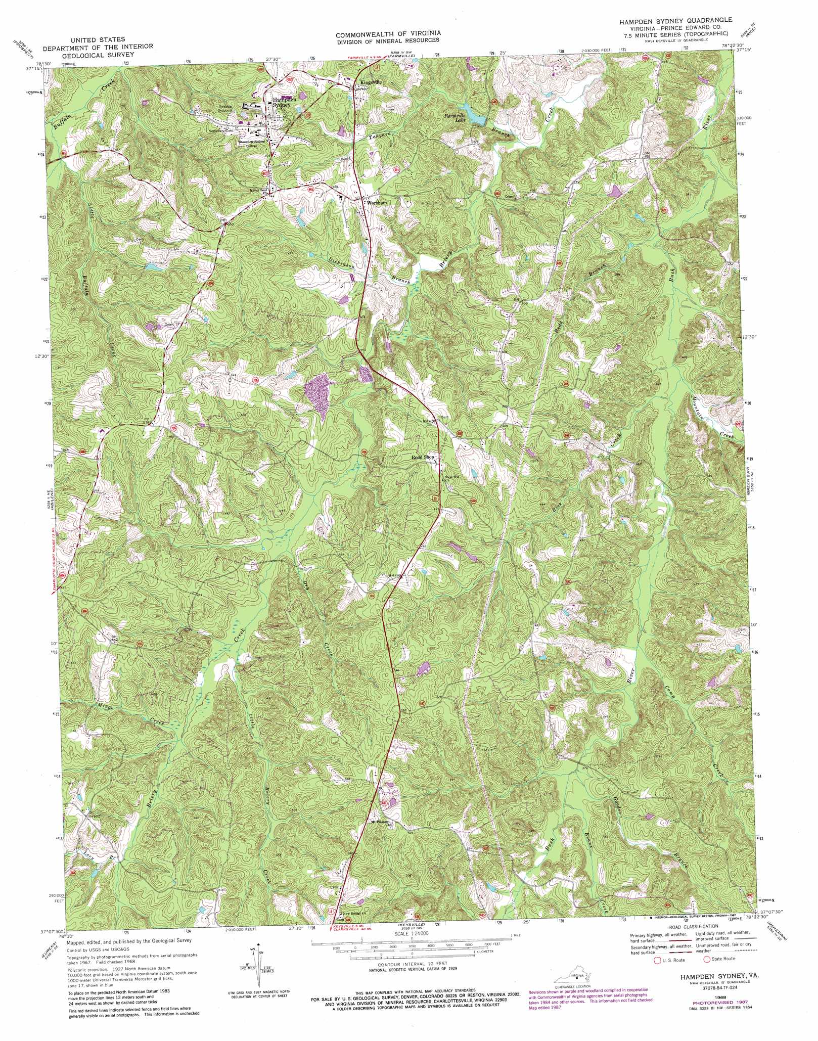
USGS Topo Quad 37078b4 - 1:24,000 scale
| Topo Map Name: | Hampden Sydney |
| USGS Topo Quad ID: | 37078b4 |
| Print Size: | ca. 21 1/4" wide x 27" high |
| Southeast Coordinates: | 37.125° N latitude / 78.375° W longitude |
| Map Center Coordinates: | 37.1875° N latitude / 78.4375° W longitude |
| U.S. State: | VA |
| Filename: | o37078b4.jpg |
| Download Map JPG Image: | Hampden Sydney topo map 1:24,000 scale |
| Map Type: | Topographic |
| Topo Series: | 7.5´ |
| Map Scale: | 1:24,000 |
| Source of Map Images: | United States Geological Survey (USGS) |
| Alternate Map Versions: |
Hampden Sydney VA 1968, updated 1972 Download PDF Buy paper map Hampden Sydney VA 1968, updated 1978 Download PDF Buy paper map Hampden Sydney VA 1968, updated 1987 Download PDF Buy paper map Hampden Sydney VA 2010 Download PDF Buy paper map Hampden Sydney VA 2013 Download PDF Buy paper map Hampden Sydney VA 2016 Download PDF Buy paper map |
1:24,000 Topo Quads surrounding Hampden Sydney
Holiday Lake |
Andersonville |
Willis Mountain |
Hillcrest |
Cumberland |
Pamplin |
Prospect |
Farmville |
Rice |
Deatonville |
Madisonville |
Abilene |
Hampden Sydney |
Green Bay |
Crewe West |
Charlotte Court House |
Eureka |
Keysville |
Meherrin |
Rubermont |
Saxe |
Drakes Branch |
Fort Mitchell |
Lunenburg |
Kenbridge West |
> Back to 37078a1 at 1:100,000 scale
> Back to 37078a1 at 1:250,000 scale
> Back to U.S. Topo Maps home
Hampden Sydney topo map: Gazetteer
Hampden Sydney: Airports
Providence Airport elevation 139m 456′Hampden Sydney: Dams
Farmville Dam elevation 127m 416′Sterling Lake Dam elevation 145m 475′
Hampden Sydney: Parks
Hampden Sydney College Historic District elevation 164m 538′Hundley Stadium elevation 153m 501′
Hampden Sydney: Populated Places
Blake Village elevation 161m 528′Hampden Sydney elevation 163m 534′
Kingsville elevation 149m 488′
Worsham elevation 144m 472′
Hampden Sydney: Reservoirs
Chalgrove Lake elevation 146m 479′Farmville Lake elevation 127m 416′
Sterling Lake elevation 145m 475′
Hampden Sydney: Streams
Camp Creek elevation 107m 351′Cunninghams Creek elevation 94m 308′
Dickinson Branch elevation 105m 344′
Dry Creek elevation 115m 377′
Evans Creek elevation 112m 367′
Goodes Branch elevation 110m 360′
Lacy Branch elevation 132m 433′
Little Briery Creek elevation 118m 387′
Little Buffalo Creek elevation 108m 354′
Mingo Creek elevation 123m 403′
Mountain Creek elevation 100m 328′
Redd Branch elevation 96m 314′
Rice Creek elevation 100m 328′
Spring Creek elevation 106m 347′
Tanyard Branch elevation 103m 337′
Hampden Sydney digital topo map on disk
Buy this Hampden Sydney topo map showing relief, roads, GPS coordinates and other geographical features, as a high-resolution digital map file on DVD:
Western Virginia & Southern West Virginia
Buy digital topo maps: Western Virginia & Southern West Virginia