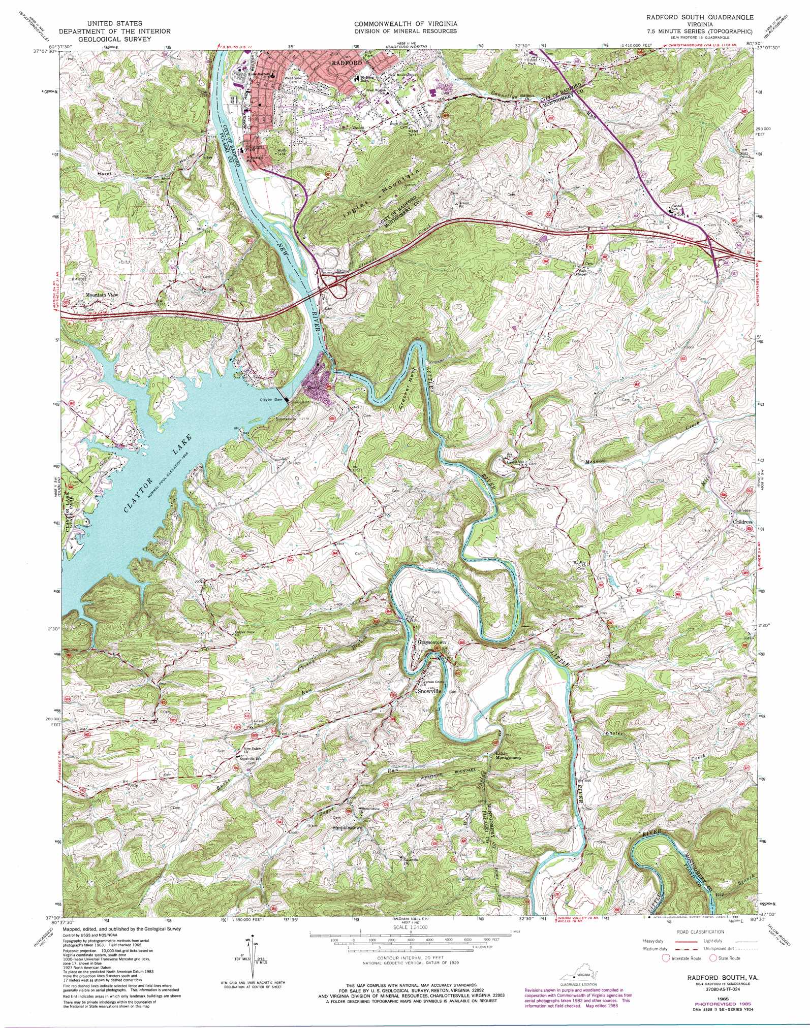
Radford South Topo Map Virginia
To zoom in, hover over the map of Radford South
USGS Topo Quad 37080a5 - 1:24,000 scale
| Topo Map Name: | Radford South |
| USGS Topo Quad ID: | 37080a5 |
| Print Size: | ca. 21 1/4" wide x 27" high |
| Southeast Coordinates: | 37° N latitude / 80.5° W longitude |
| Map Center Coordinates: | 37.0625° N latitude / 80.5625° W longitude |
| U.S. State: | VA |
| Filename: | o37080a5.jpg |
| Download Map JPG Image: | Radford South topo map 1:24,000 scale |
| Map Type: | Topographic |
| Topo Series: | 7.5´ |
| Map Scale: | 1:24,000 |
| Source of Map Images: | United States Geological Survey (USGS) |
| Alternate Map Versions: |
Radford South VA 1965, updated 1966 Download PDF Buy paper map Radford South VA 1965, updated 1971 Download PDF Buy paper map Radford South VA 1965, updated 1978 Download PDF Buy paper map Radford South VA 1965, updated 1986 Download PDF Buy paper map Radford South VA 1965, updated 1986 Download PDF Buy paper map Radford South VA 2011 Download PDF Buy paper map Radford South VA 2013 Download PDF Buy paper map Radford South VA 2016 Download PDF Buy paper map |
1:24,000 Topo Quads surrounding Radford South
Narrows |
Pearisburg |
Eggleston |
Newport |
Mcdonalds Mill |
White Gate |
Staffordsville |
Radford North |
Blacksburg |
Ironto |
Pulaski |
Dublin |
Radford South |
Riner |
Pilot |
Fosters Falls |
Hiwassee |
Indian Valley |
Alum Ridge |
Floyd |
Sylvatus |
Hillsville |
Dugspur |
Willis |
Woolwine |
> Back to 37080a1 at 1:100,000 scale
> Back to 37080a1 at 1:250,000 scale
> Back to U.S. Topo Maps home
Radford South topo map: Gazetteer
Radford South: Bridges
Ingles Ferry Bridge elevation 527m 1729′Radford South: Capes
Cracker Neck elevation 546m 1791′Radford South: Crossings
Ingles Ferry (historical) elevation 527m 1729′Interchange 105 elevation 547m 1794′
Interchange 109 elevation 628m 2060′
Radford South: Dams
Claytor Dam elevation 553m 1814′Little River Dam elevation 551m 1807′
Radford South: Parks
Riverview Park elevation 533m 1748′Radford South: Populated Places
Childress elevation 599m 1965′Forest Park elevation 587m 1925′
Graysontown elevation 573m 1879′
Highland Hills elevation 579m 1899′
Little Montgomery elevation 586m 1922′
Mountain View elevation 625m 2050′
New Town elevation 534m 1751′
Radford Village elevation 587m 1925′
Ridgefield elevation 580m 1902′
Simpkins Village elevation 588m 1929′
Simpkinstown elevation 634m 2080′
Smithfield elevation 580m 1902′
Snowville elevation 589m 1932′
Sunset Village elevation 581m 1906′
Willow Woods elevation 582m 1909′
Radford South: Reservoirs
Claytor Lake elevation 553m 1814′Little River Reservoir elevation 551m 1807′
Radford South: Streams
Big Branch elevation 609m 1998′Burks Run elevation 563m 1847′
Burks Run elevation 558m 1830′
Cherry Branch elevation 564m 1850′
Easter Creek elevation 576m 1889′
Little River elevation 537m 1761′
Meadow Creek elevation 553m 1814′
Mill Creek elevation 578m 1896′
Strouds Creek elevation 533m 1748′
Sugar Run elevation 579m 1899′
Wolf Spring Branch elevation 576m 1889′
Radford South: Summits
Ingles Mountain elevation 700m 2296′Radford South: Valleys
Hazel Hollow elevation 532m 1745′Radford South digital topo map on disk
Buy this Radford South topo map showing relief, roads, GPS coordinates and other geographical features, as a high-resolution digital map file on DVD:
Western Virginia & Southern West Virginia
Buy digital topo maps: Western Virginia & Southern West Virginia