Bighill Topo Map Kentucky
To zoom in, hover over the map of Bighill
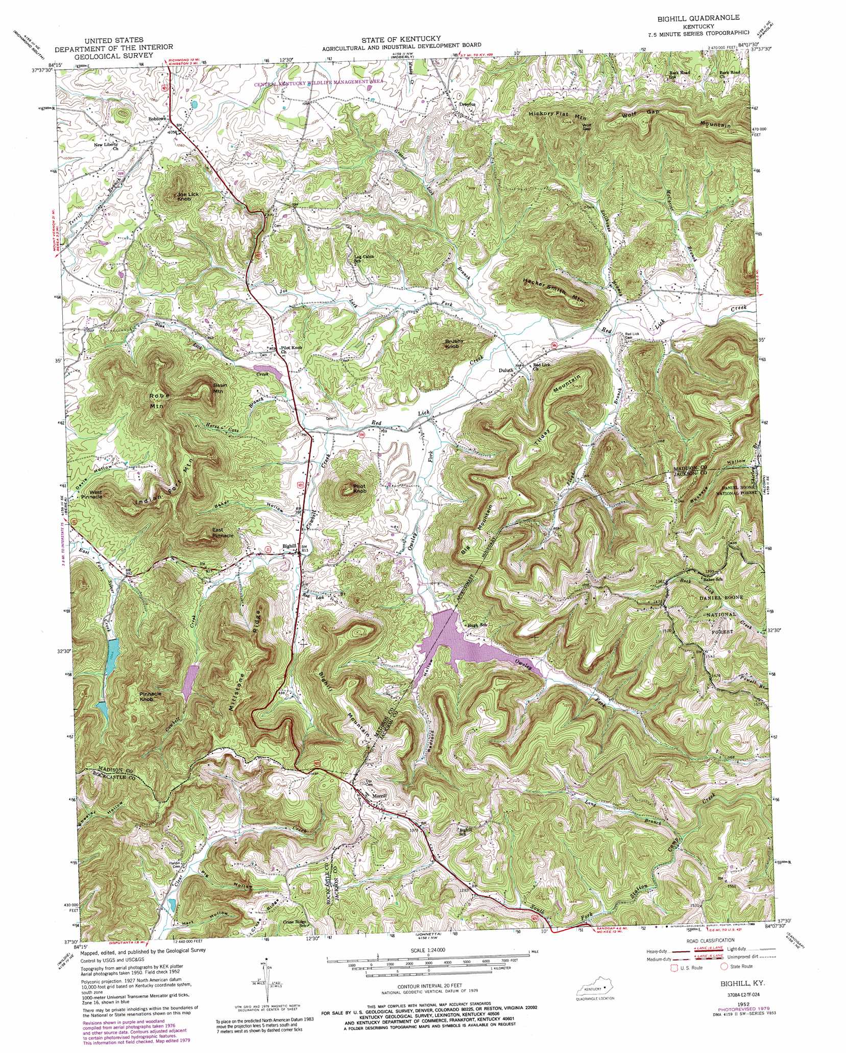
USGS Topo Quad 37084e2 - 1:24,000 scale
| Topo Map Name: | Bighill |
| USGS Topo Quad ID: | 37084e2 |
| Print Size: | ca. 21 1/4" wide x 27" high |
| Southeast Coordinates: | 37.5° N latitude / 84.125° W longitude |
| Map Center Coordinates: | 37.5625° N latitude / 84.1875° W longitude |
| U.S. State: | KY |
| Filename: | o37084e2.jpg |
| Download Map JPG Image: | Bighill topo map 1:24,000 scale |
| Map Type: | Topographic |
| Topo Series: | 7.5´ |
| Map Scale: | 1:24,000 |
| Source of Map Images: | United States Geological Survey (USGS) |
| Alternate Map Versions: |
Bighill KY 1952, updated 1954 Download PDF Buy paper map Bighill KY 1952, updated 1967 Download PDF Buy paper map Bighill KY 1952, updated 1979 Download PDF Buy paper map Bighill KY 1952, updated 1989 Download PDF Buy paper map Bighill KY 2011 Download PDF Buy paper map Bighill KY 2013 Download PDF Buy paper map Bighill KY 2016 Download PDF Buy paper map |
| FStopo: | US Forest Service topo Bighill is available: Download FStopo PDF Download FStopo TIF |
1:24,000 Topo Quads surrounding Bighill
Valley View |
Richmond North |
Union City |
Palmer |
Clay City |
Kirksville |
Richmond South |
Moberly |
Panola |
Irvine |
Paint Lick |
Berea |
Bighill |
Alcorn |
Leighton |
Brodhead |
Wildie |
Johnetta |
Sandgap |
Mckee |
Maretburg |
Mount Vernon |
Livingston |
Parrot |
Tyner |
> Back to 37084e1 at 1:100,000 scale
> Back to 37084a1 at 1:250,000 scale
> Back to U.S. Topo Maps home
Bighill topo map: Gazetteer
Bighill: Forests
Berea College Forest elevation 338m 1108′Bighill: Gaps
Horseshoe Gap elevation 406m 1332′Wolf Gap elevation 388m 1272′
Bighill: Pillars
East Pinnacle elevation 446m 1463′West Pinnacle elevation 414m 1358′
Bighill: Populated Places
Baker elevation 413m 1354′Big Hill elevation 459m 1505′
Bighill elevation 244m 800′
Bobtown elevation 321m 1053′
Dreyfus elevation 298m 977′
Duluth elevation 240m 787′
Hugh elevation 250m 820′
Morrill elevation 454m 1489′
Bighill: Post Offices
Coyle Post Office (historical) elevation 247m 810′Dreyfus Post Office (historical) elevation 301m 987′
Duluth Post Office (historical) elevation 239m 784′
Hugh Post Office (historical) elevation 253m 830′
Morrill Post Office (historical) elevation 450m 1476′
Shirley Post Office (historical) elevation 350m 1148′
Walnut Valley Post Office (historical) elevation 242m 793′
Bighill: Reservoirs
Berea City Lakes elevation 318m 1043′Owsley Fork Reservoir elevation 241m 790′
Bighill: Ridges
Millstone Ridge elevation 468m 1535′Bighill: Springs
Red Lick Sulphur Spring elevation 295m 967′Sulphur Spring elevation 262m 859′
Bighill: Streams
Blue Lick Creek elevation 241m 790′Cowbell Creek elevation 232m 761′
Floyd Branch elevation 220m 721′
Gravel Lick Branch elevation 226m 741′
Horse Cove Branch elevation 241m 790′
Joe Lick Fork elevation 223m 731′
Long Branch elevation 363m 1190′
McCarter Branch elevation 215m 705′
Owsley Fork elevation 226m 741′
Red Lick Branch elevation 248m 813′
Stillhouse Branch elevation 219m 718′
Bighill: Summits
Basin Mountain elevation 447m 1466′Big Mountain elevation 441m 1446′
Bighill Mountain elevation 460m 1509′
Brushy Knob elevation 337m 1105′
Croley Mountain elevation 484m 1587′
Hacker Smith Mountain elevation 402m 1318′
Hickory Flat Mountain elevation 418m 1371′
Indian Fort Mountain elevation 470m 1541′
Joe Lick Knob elevation 443m 1453′
Pilot Knob elevation 390m 1279′
Pinnacle Knob elevation 482m 1581′
Robe Mountain elevation 462m 1515′
Tilday Mountain elevation 397m 1302′
Wolf Gap Mountain elevation 458m 1502′
Bighill: Valleys
Baker Hollow elevation 242m 793′Buckeye Hollow elevation 254m 833′
Hart Hollow elevation 329m 1079′
Pig Hollow elevation 336m 1102′
Radford Hollow elevation 241m 790′
Bighill digital topo map on disk
Buy this Bighill topo map showing relief, roads, GPS coordinates and other geographical features, as a high-resolution digital map file on DVD: