Leighton Topo Map Kentucky
To zoom in, hover over the map of Leighton
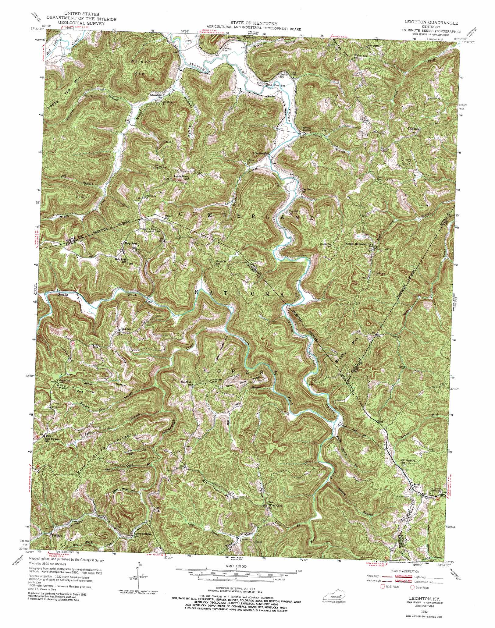
USGS Topo Quad 37083e8 - 1:24,000 scale
| Topo Map Name: | Leighton |
| USGS Topo Quad ID: | 37083e8 |
| Print Size: | ca. 21 1/4" wide x 27" high |
| Southeast Coordinates: | 37.5° N latitude / 83.875° W longitude |
| Map Center Coordinates: | 37.5625° N latitude / 83.9375° W longitude |
| U.S. State: | KY |
| Filename: | o37083e8.jpg |
| Download Map JPG Image: | Leighton topo map 1:24,000 scale |
| Map Type: | Topographic |
| Topo Series: | 7.5´ |
| Map Scale: | 1:24,000 |
| Source of Map Images: | United States Geological Survey (USGS) |
| Alternate Map Versions: |
Leighton KY 1952 Download PDF Buy paper map Leighton KY 1952, updated 1955 Download PDF Buy paper map Leighton KY 1952, updated 1968 Download PDF Buy paper map Leighton KY 1952, updated 1989 Download PDF Buy paper map Leighton KY 2011 Download PDF Buy paper map Leighton KY 2013 Download PDF Buy paper map Leighton KY 2016 Download PDF Buy paper map |
| FStopo: | US Forest Service topo Leighton is available: Download FStopo PDF Download FStopo TIF |
1:24,000 Topo Quads surrounding Leighton
Union City |
Palmer |
Clay City |
Stanton |
Slade |
Moberly |
Panola |
Irvine |
Cobhill |
Zachariah |
Bighill |
Alcorn |
Leighton |
Heidelberg |
Beattyville |
Johnetta |
Sandgap |
Mckee |
Sturgeon |
Booneville |
Livingston |
Parrot |
Tyner |
Maulden |
Oneida |
> Back to 37083e1 at 1:100,000 scale
> Back to 37082a1 at 1:250,000 scale
> Back to U.S. Topo Maps home
Leighton topo map: Gazetteer
Leighton: Crossings
Slick Ford elevation 189m 620′Leighton: Flats
Blanton Flats elevation 334m 1095′Russell Flat elevation 423m 1387′
Leighton: Populated Places
Alumbaugh elevation 192m 629′Arvel elevation 369m 1210′
Drip Rock elevation 416m 1364′
Fairview elevation 413m 1354′
Foxtown elevation 326m 1069′
Greenbriar (historical) elevation 197m 646′
Lakes elevation 298m 977′
Leighton elevation 386m 1266′
Lynch Town elevation 389m 1276′
Salt Rock elevation 393m 1289′
Sand Springs elevation 422m 1384′
South Fork elevation 351m 1151′
Walnut Gap elevation 399m 1309′
Wind Cave elevation 310m 1017′
Leighton: Post Offices
Alumbaugh Post Office (historical) elevation 195m 639′Drip Rick Post Office (historical) elevation 415m 1361′
Drip Rock Post Office elevation 418m 1371′
Estilco Post Office (historical) elevation 216m 708′
Foxtown Post Office (historical) elevation 326m 1069′
Laura Post Office (historical) elevation 287m 941′
Leighton Post Office (historical) elevation 237m 777′
Powell Post Office (historical) elevation 201m 659′
Sand Springs Post Office (historical) elevation 427m 1400′
Wind Cave Post Office (historical) elevation 315m 1033′
Leighton: Ridges
Cedar Point Ridge elevation 335m 1099′Hurd Spring Ridge elevation 416m 1364′
Leighton: Streams
Alcorn Branch elevation 213m 698′Ash Ground Branch elevation 314m 1030′
Ash Gut Branch elevation 207m 679′
Beth Branch elevation 195m 639′
Cavanaugh Creek elevation 234m 767′
Cox Cave Branch elevation 267m 875′
Dry Fork Branch elevation 294m 964′
Edwards Branch elevation 197m 646′
Elk Branch elevation 217m 711′
Fall Branch elevation 262m 859′
Harris Branch elevation 317m 1040′
Jones Branch elevation 189m 620′
Lakes Branch elevation 298m 977′
Left Fork Sand Springs Branch elevation 342m 1122′
Little Buck Lick Branch elevation 226m 741′
Middle Fork Station Camp Creek elevation 189m 620′
Mill Seat Branch elevation 212m 695′
Polly Spark Branch elevation 207m 679′
Sand Spring Branch elevation 322m 1056′
Scrivner Branch elevation 189m 620′
Searcy Branch elevation 195m 639′
South Fork Station Camp Creek elevation 206m 675′
Sparks Branch elevation 200m 656′
Tarpin Lick Branch elevation 216m 708′
War Fork elevation 206m 675′
Wind Cave Branch elevation 281m 921′
Wood Cutting Branch elevation 234m 767′
Leighton: Summits
Brushy Mountain elevation 401m 1315′Wilson Mountain elevation 381m 1250′
Leighton: Valleys
Abner Hollow elevation 323m 1059′Cedar House Hollow elevation 217m 711′
Hopper Cave Branch elevation 234m 767′
Napper Hollow elevation 201m 659′
Silver Mine Hollow elevation 274m 898′
Spice Lick Branch elevation 240m 787′
Leighton digital topo map on disk
Buy this Leighton topo map showing relief, roads, GPS coordinates and other geographical features, as a high-resolution digital map file on DVD:
Western Virginia & Southern West Virginia
Buy digital topo maps: Western Virginia & Southern West Virginia