Winchester Topo Map Kentucky
To zoom in, hover over the map of Winchester
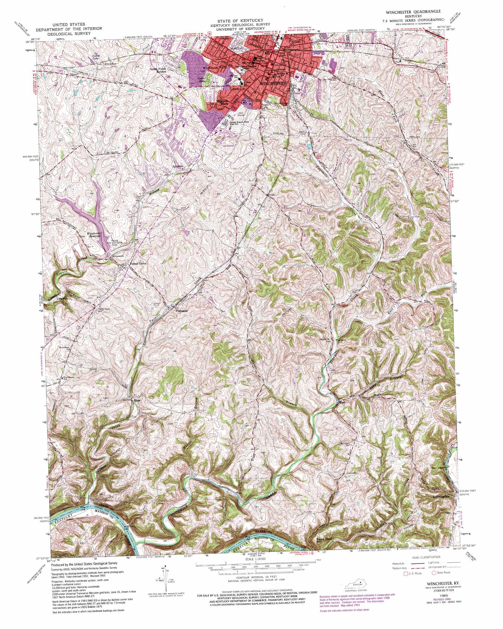
USGS Topo Quad 37084h2 - 1:24,000 scale
| Topo Map Name: | Winchester |
| USGS Topo Quad ID: | 37084h2 |
| Print Size: | ca. 21 1/4" wide x 27" high |
| Southeast Coordinates: | 37.875° N latitude / 84.125° W longitude |
| Map Center Coordinates: | 37.9375° N latitude / 84.1875° W longitude |
| U.S. State: | KY |
| Filename: | o37084h2.jpg |
| Download Map JPG Image: | Winchester topo map 1:24,000 scale |
| Map Type: | Topographic |
| Topo Series: | 7.5´ |
| Map Scale: | 1:24,000 |
| Source of Map Images: | United States Geological Survey (USGS) |
| Alternate Map Versions: |
Winchester KY 1952, updated 1954 Download PDF Buy paper map Winchester KY 1959, updated 1960 Download PDF Buy paper map Winchester KY 1965, updated 1966 Download PDF Buy paper map Winchester KY 1965, updated 1979 Download PDF Buy paper map Winchester KY 1965, updated 1993 Download PDF Buy paper map Winchester KY 2010 Download PDF Buy paper map Winchester KY 2013 Download PDF Buy paper map Winchester KY 2016 Download PDF Buy paper map |
1:24,000 Topo Quads surrounding Winchester
Centerville |
Paris West |
Paris East |
North Middletown |
Sharpsburg |
Lexington East |
Clintonville |
Austerlitz |
Sideview |
Mount Sterling |
Coletown |
Ford |
Winchester |
Hedges |
Levee |
Valley View |
Richmond North |
Union City |
Palmer |
Clay City |
Kirksville |
Richmond South |
Moberly |
Panola |
Irvine |
> Back to 37084e1 at 1:100,000 scale
> Back to 37084a1 at 1:250,000 scale
> Back to U.S. Topo Maps home
Winchester topo map: Gazetteer
Winchester: Lakes
Codell Lake elevation 296m 971′Winchester: Populated Places
Allensville elevation 186m 610′Bloomingdale elevation 193m 633′
Colby Hills elevation 303m 994′
Elkin elevation 222m 728′
Flanagan elevation 271m 889′
Forest Grove elevation 274m 898′
Franklin elevation 279m 915′
Green Fields Estates elevation 302m 990′
Greenfield Estates elevation 302m 990′
Haggard elevation 296m 971′
Hampton Manor elevation 299m 980′
Hunt elevation 243m 797′
Jackson Ferry elevation 278m 912′
Lyndale elevation 277m 908′
Olivers elevation 211m 692′
Pinchem elevation 242m 793′
Providence elevation 291m 954′
Saddlebrook elevation 298m 977′
Wesleyan Park elevation 300m 984′
Winchester elevation 303m 994′
Winchester: Post Offices
Bloomington Post Office (historical) elevation 186m 610′Elkins Post Office (historical) elevation 222m 728′
Flanagan Post Office (historical) elevation 268m 879′
Hunt Post Office (historical) elevation 230m 754′
Locknane Post Office (historical) elevation 284m 931′
Tulip Post Office (historical) elevation 247m 810′
Wilbur Post Office (historical) elevation 288m 944′
Winchester Post Office elevation 294m 964′
Winchester: Reservoirs
Winchester Reservoir elevation 251m 823′Winchester: Ridges
Pleasant Ridge elevation 290m 951′Winchester: Streams
East Fork Fourmile Creek elevation 239m 784′Fourmile Creek elevation 173m 567′
Harris Branch elevation 191m 626′
Long Branch elevation 227m 744′
Stoner Branch elevation 224m 734′
Twomile Creek elevation 172m 564′
Winchester: Summits
Eagle Nest Hill elevation 260m 853′Winchester digital topo map on disk
Buy this Winchester topo map showing relief, roads, GPS coordinates and other geographical features, as a high-resolution digital map file on DVD: