Dunnville Topo Map Kentucky
To zoom in, hover over the map of Dunnville
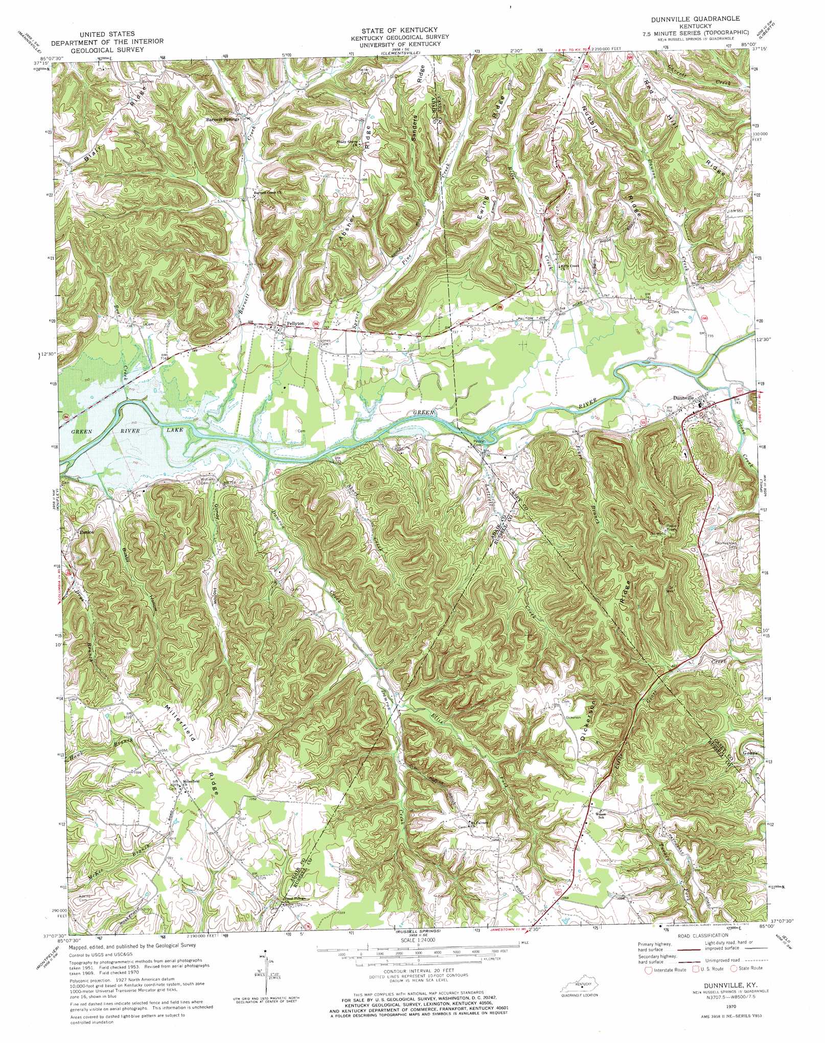
USGS Topo Quad 37085b1 - 1:24,000 scale
| Topo Map Name: | Dunnville |
| USGS Topo Quad ID: | 37085b1 |
| Print Size: | ca. 21 1/4" wide x 27" high |
| Southeast Coordinates: | 37.125° N latitude / 85° W longitude |
| Map Center Coordinates: | 37.1875° N latitude / 85.0625° W longitude |
| U.S. State: | KY |
| Filename: | o37085b1.jpg |
| Download Map JPG Image: | Dunnville topo map 1:24,000 scale |
| Map Type: | Topographic |
| Topo Series: | 7.5´ |
| Map Scale: | 1:24,000 |
| Source of Map Images: | United States Geological Survey (USGS) |
| Alternate Map Versions: |
Dunnville KY 1953, updated 1955 Download PDF Buy paper map Dunnville KY 1953, updated 1969 Download PDF Buy paper map Dunnville KY 1970, updated 1972 Download PDF Buy paper map Dunnville KY 2010 Download PDF Buy paper map Dunnville KY 2013 Download PDF Buy paper map Dunnville KY 2016 Download PDF Buy paper map |
1:24,000 Topo Quads surrounding Dunnville
Spurlington |
Bradfordsville |
Bradfordsville Ne |
Ellisburg |
Hustonville |
Campbellsville |
Mannsville |
Clementsville |
Liberty |
Yosemite |
Cane Valley |
Knifley |
Dunnville |
Phil |
Mintonville |
Columbia |
Montpelier |
Russell Springs |
Eli |
Faubush |
Amandaville |
Creelsboro |
Jamestown |
Jabez |
Mill Springs |
> Back to 37085a1 at 1:100,000 scale
> Back to 37084a1 at 1:250,000 scale
> Back to U.S. Topo Maps home
Dunnville topo map: Gazetteer
Dunnville: Populated Places
Barnett Springs elevation 241m 790′Dunnville elevation 227m 744′
Eunice elevation 238m 780′
Pellyton elevation 226m 741′
Dunnville: Post Offices
Rife Creek Post Office (historical) elevation 226m 741′Dunnville: Ridges
Absher Ridge elevation 309m 1013′Dickerson Ridge elevation 325m 1066′
Ewing Ridge elevation 308m 1010′
Millerfield Ridge elevation 318m 1043′
Nubbin Ridge elevation 307m 1007′
Red Hill Ridge elevation 309m 1013′
Sanders Ridge elevation 314m 1030′
Dunnville: Streams
Barnett Creek elevation 214m 702′Bear Creek elevation 213m 698′
Damron Creek elevation 215m 705′
Dawson Creek elevation 219m 718′
Ellis Fork elevation 239m 784′
Goose Creek elevation 219m 718′
Jones Branch elevation 219m 718′
Luttrell Creek elevation 219m 718′
Riffe Creek elevation 219m 718′
Short Creek elevation 216m 708′
Spruce Pine Creek elevation 216m 708′
Dunnville: Valleys
Busby Hollow elevation 219m 718′Gundy Hollow elevation 219m 718′
Dunnville digital topo map on disk
Buy this Dunnville topo map showing relief, roads, GPS coordinates and other geographical features, as a high-resolution digital map file on DVD: