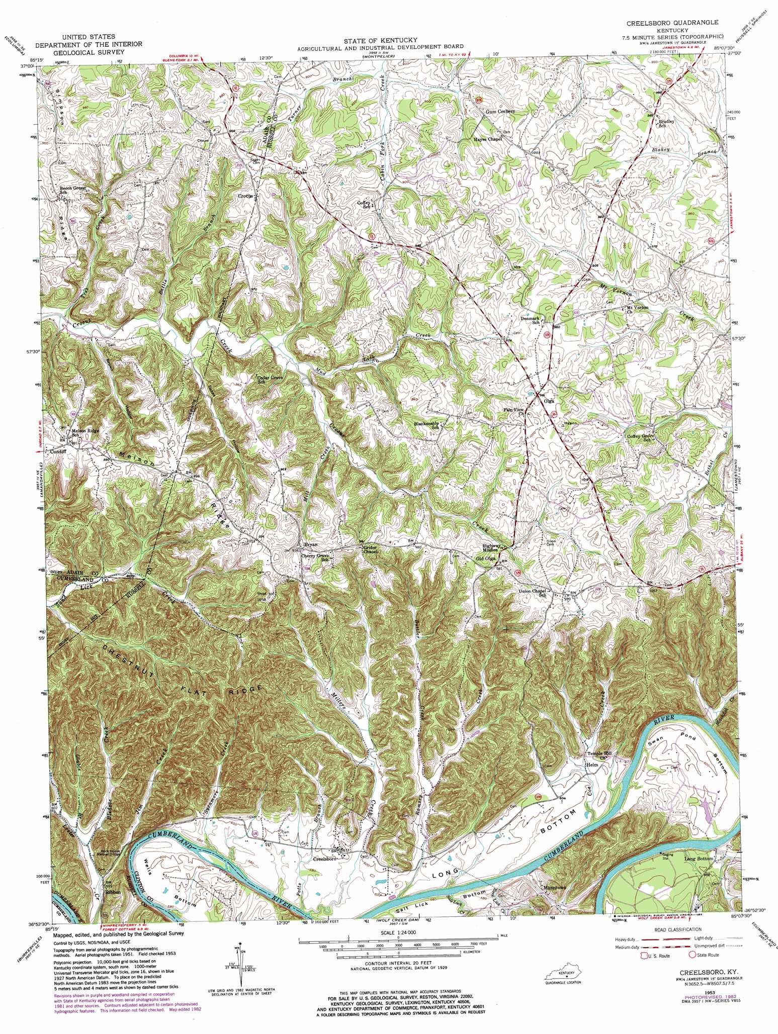
Creelsboro Topo Map Kentucky
To zoom in, hover over the map of Creelsboro
USGS Topo Quad 36085h2 - 1:24,000 scale
| Topo Map Name: | Creelsboro |
| USGS Topo Quad ID: | 36085h2 |
| Print Size: | ca. 21 1/4" wide x 27" high |
| Southeast Coordinates: | 36.875° N latitude / 85.125° W longitude |
| Map Center Coordinates: | 36.9375° N latitude / 85.1875° W longitude |
| U.S. State: | KY |
| Filename: | o36085h2.jpg |
| Download Map JPG Image: | Creelsboro topo map 1:24,000 scale |
| Map Type: | Topographic |
| Topo Series: | 7.5´ |
| Map Scale: | 1:24,000 |
| Source of Map Images: | United States Geological Survey (USGS) |
| Alternate Map Versions: |
Creelsboro KY 1953, updated 1955 Download PDF Buy paper map Creelsboro KY 1953, updated 1972 Download PDF Buy paper map Creelsboro KY 1953, updated 1983 Download PDF Buy paper map Creelsboro KY 2010 Download PDF Buy paper map Creelsboro KY 2013 Download PDF Buy paper map Creelsboro KY 2016 Download PDF Buy paper map |
1:24,000 Topo Quads surrounding Creelsboro
Gresham |
Cane Valley |
Knifley |
Dunnville |
Phil |
Gradyville |
Columbia |
Montpelier |
Russell Springs |
Eli |
Breeding |
Amandaville |
Creelsboro |
Jamestown |
Jabez |
Waterview |
Burkesville |
Wolf Creek Dam |
Cumberland City |
Parnell |
Blacks Ferry |
Frogue |
Albany |
Savage |
Powersburg |
> Back to 36085e1 at 1:100,000 scale
> Back to 36084a1 at 1:250,000 scale
> Back to U.S. Topo Maps home
Creelsboro topo map: Gazetteer
Creelsboro: Arches
Rock House Natural Bridge elevation 199m 652′Creelsboro: Bends
Long Bottom elevation 183m 600′Salt Lick Bottom elevation 180m 590′
Swan Pond Bottom elevation 183m 600′
Wells Bottom elevation 184m 603′
Creelsboro: Populated Places
Bryan elevation 282m 925′Creelsboro elevation 189m 620′
Crocus elevation 301m 987′
Helm elevation 175m 574′
Long Bottom elevation 179m 587′
Manntown elevation 180m 590′
Old Olga elevation 298m 977′
Olga elevation 300m 984′
Ribbon elevation 183m 600′
Creelsboro: Ridges
Chestnut Flat Ridge elevation 294m 964′Melson Ridge elevation 298m 977′
Simpson Ridge elevation 286m 938′
Creelsboro: Streams
Battle Branch elevation 217m 711′Blackfish Creek elevation 170m 557′
Bledsoe Creek elevation 179m 587′
Buttler Creek elevation 179m 587′
Coe Creek elevation 173m 567′
Glable Branch elevation 180m 590′
Jim Creek elevation 160m 524′
Little Indian Creek elevation 169m 554′
Mill Creek elevation 237m 777′
Millers Creek elevation 171m 561′
Mud Lick Creek elevation 231m 757′
Potts Branch elevation 172m 564′
Ramsey Creek elevation 174m 570′
Rock Lick Creek elevation 172m 564′
Salt Lick Creek elevation 173m 567′
Sycamore Creek elevation 169m 554′
Tres Creek elevation 207m 679′
Turner Branch elevation 254m 833′
Creelsboro: Valleys
Brown Hollow elevation 210m 688′Dykes Hollow elevation 224m 734′
Creelsboro digital topo map on disk
Buy this Creelsboro topo map showing relief, roads, GPS coordinates and other geographical features, as a high-resolution digital map file on DVD: