Flake Mountain East Topo Map Utah
To zoom in, hover over the map of Flake Mountain East
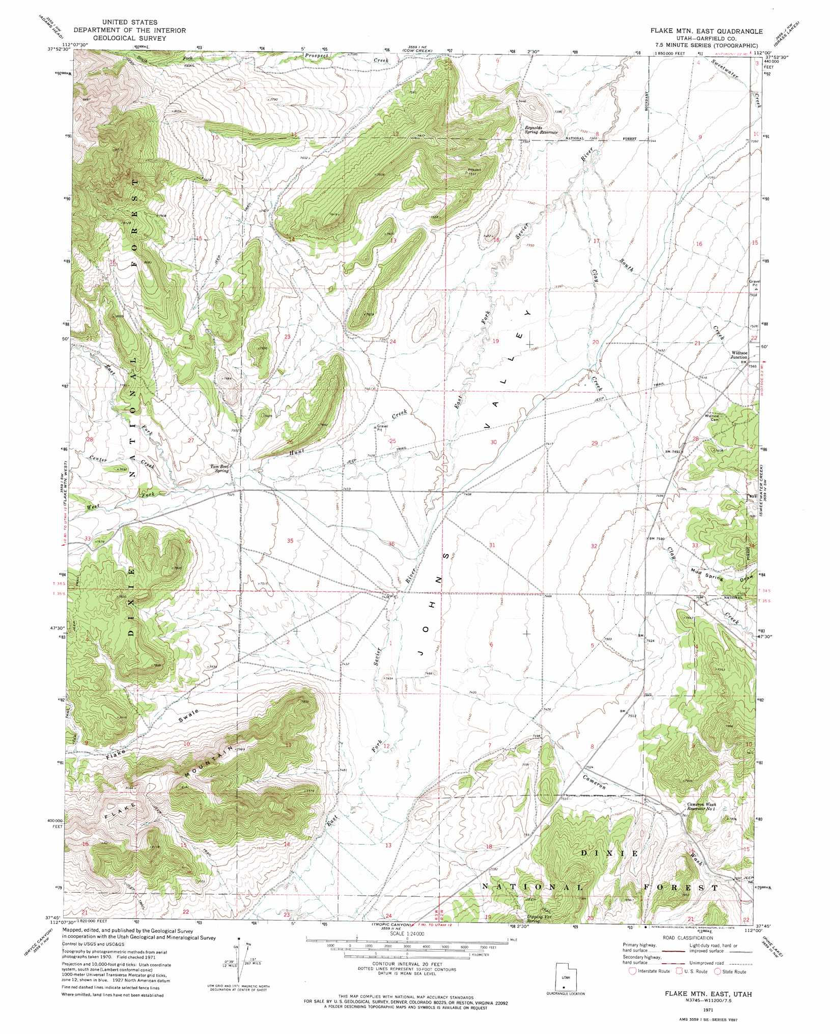
USGS Topo Quad 37112g1 - 1:24,000 scale
| Topo Map Name: | Flake Mountain East |
| USGS Topo Quad ID: | 37112g1 |
| Print Size: | ca. 21 1/4" wide x 27" high |
| Southeast Coordinates: | 37.75° N latitude / 112° W longitude |
| Map Center Coordinates: | 37.8125° N latitude / 112.0625° W longitude |
| U.S. State: | UT |
| Filename: | o37112g1.jpg |
| Download Map JPG Image: | Flake Mountain East topo map 1:24,000 scale |
| Map Type: | Topographic |
| Topo Series: | 7.5´ |
| Map Scale: | 1:24,000 |
| Source of Map Images: | United States Geological Survey (USGS) |
| Alternate Map Versions: |
Flake Mtn East UT 1971, updated 1974 Download PDF Buy paper map Flake Mountain East UT 2011 Download PDF Buy paper map Flake Mountain East UT 2014 Download PDF Buy paper map |
| FStopo: | US Forest Service topo Flake Mountain East is available: Download FStopo PDF Download FStopo TIF |
1:24,000 Topo Quads surrounding Flake Mountain East
Bull Rush Peak |
Mount Dutton |
Deep Creek |
Antimony |
Pollywog Lake |
Blind Spring Mountain |
Adams Head |
Cow Creek |
Grass Lakes |
Barker Reservoir |
Casto Canyon |
Flake Mountain West |
Flake Mountain East |
Sweetwater Creek |
Griffin Point |
Wilson Peak |
Bryce Canyon |
Tropic Canyon |
Pine Lake |
Upper Valley |
Tropic Reservoir |
Bryce Point |
Cannonville |
Henrieville |
Canaan Peak |
> Back to 37112e1 at 1:100,000 scale
> Back to 37112a1 at 1:250,000 scale
> Back to U.S. Topo Maps home
Flake Mountain East topo map: Gazetteer
Flake Mountain East: Populated Places
Widtsoe Junction elevation 2307m 7568′Flake Mountain East: Reservoirs
Cameron Wash Reservoir Number 1 elevation 2327m 7634′Reynolds Spring Reservoir elevation 2247m 7372′
Flake Mountain East: Springs
Dipping Vat Spring elevation 2370m 7775′Tom Best Spring elevation 2293m 7522′
Flake Mountain East: Streams
Center Creek elevation 2304m 7559′Clay Creek elevation 2232m 7322′
East Fork Hunt Creek elevation 2303m 7555′
Hunt Creek elevation 2245m 7365′
North Fork Prospect Creek elevation 2362m 7749′
South Creek elevation 2232m 7322′
South Fork Prospect Creek elevation 2362m 7749′
West Fork Hunt Creek elevation 2303m 7555′
Flake Mountain East: Summits
Flake Mountain elevation 2453m 8047′Flake Mountain East: Valleys
Cameron Wash elevation 2264m 7427′Flake Swale elevation 2268m 7440′
Mud Spring Draw elevation 2306m 7565′
Flake Mountain East digital topo map on disk
Buy this Flake Mountain East topo map showing relief, roads, GPS coordinates and other geographical features, as a high-resolution digital map file on DVD: