Pollywog Lake Topo Map Utah
To zoom in, hover over the map of Pollywog Lake
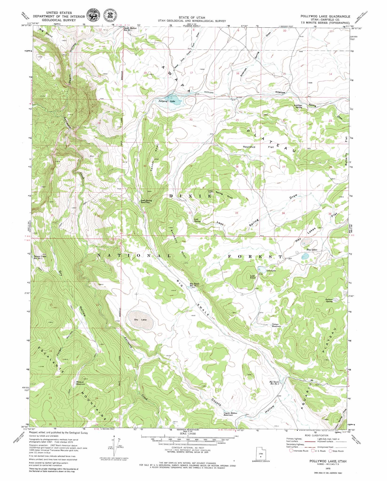
USGS Topo Quad 38111a7 - 1:24,000 scale
| Topo Map Name: | Pollywog Lake |
| USGS Topo Quad ID: | 38111a7 |
| Print Size: | ca. 21 1/4" wide x 27" high |
| Southeast Coordinates: | 38° N latitude / 111.75° W longitude |
| Map Center Coordinates: | 38.0625° N latitude / 111.8125° W longitude |
| U.S. State: | UT |
| Filename: | o38111a7.jpg |
| Download Map JPG Image: | Pollywog Lake topo map 1:24,000 scale |
| Map Type: | Topographic |
| Topo Series: | 7.5´ |
| Map Scale: | 1:24,000 |
| Source of Map Images: | United States Geological Survey (USGS) |
| Alternate Map Versions: |
Pollywog Lake UT 1970, updated 1972 Download PDF Buy paper map Pollywog Lake UT 2002, updated 2005 Download PDF Buy paper map Pollywog Lake UT 2011 Download PDF Buy paper map Pollywog Lake UT 2014 Download PDF Buy paper map |
| FStopo: | US Forest Service topo Pollywog Lake is available: Download FStopo PDF Download FStopo TIF |
1:24,000 Topo Quads surrounding Pollywog Lake
Malmsten Peak |
Parker Knoll |
Jakes Knoll |
Moroni Peak |
Bicknell |
Phonolite Hill |
Angle |
Flossie Knoll |
Smooth Knoll |
Government Point |
Deep Creek |
Antimony |
Pollywog Lake |
Big Lake |
Jacobs Reservoir |
Cow Creek |
Grass Lakes |
Barker Reservoir |
Posy Lake |
Roger Peak |
Flake Mountain East |
Sweetwater Creek |
Griffin Point |
Wide Hollow Reservoir |
Escalante |
> Back to 38111a1 at 1:100,000 scale
> Back to 38110a1 at 1:250,000 scale
> Back to U.S. Topo Maps home
Pollywog Lake topo map: Gazetteer
Pollywog Lake: Canals
Antelope Ditch elevation 2806m 9206′Pollywog Lake: Dams
Pollywog Lake Dam elevation 2816m 9238′Pollywog Lake: Flats
Hay Lakes Flat elevation 2991m 9812′Roundup Flat elevation 2903m 9524′
Pollywog Lake: Lakes
Dry Lake elevation 2856m 9370′Hay Lakes elevation 2991m 9812′
Lost Lake elevation 2985m 9793′
Pollywog Lake elevation 2796m 9173′
Pollywog Lake: Reservoirs
Big Swale Reservoir Number 1 elevation 2886m 9468′Big Swale Reservoir Number 2 elevation 2885m 9465′
Corner Reservoir elevation 2963m 9721′
Coyote Hollow Reservoir elevation 2881m 9452′
Death Hollow Reservoir Number 1 elevation 2740m 8989′
Lost Spring Reservoir elevation 2805m 9202′
Poison Creek Reservoir Number 1 elevation 2836m 9304′
Pollywog Lake elevation 2816m 9238′
Wildcat Reservoir elevation 3013m 9885′
Pollywog Lake: Springs
Antelope Spring elevation 2839m 9314′Jackass Spring elevation 3035m 9957′
Lost Spring elevation 2895m 9498′
Pollywog Lake: Summits
Antimony Knoll elevation 2977m 9767′Lost Knoll elevation 3015m 9891′
Spring Knoll elevation 2979m 9773′
Tanner Knoll elevation 2913m 9557′
Pollywog Lake: Valleys
Big Swale elevation 2433m 7982′Cougar Hollow elevation 2911m 9550′
Coyote Hollow elevation 2839m 9314′
Death Hollow elevation 2294m 7526′
Dry Hollow elevation 2635m 8645′
Iron Spring Draw elevation 2884m 9461′
Lost Spring Draw elevation 2802m 9192′
Pacewell Draw elevation 2974m 9757′
Pollywog Lake digital topo map on disk
Buy this Pollywog Lake topo map showing relief, roads, GPS coordinates and other geographical features, as a high-resolution digital map file on DVD: