Whitmore Hot Springs Topo Map California
To zoom in, hover over the map of Whitmore Hot Springs
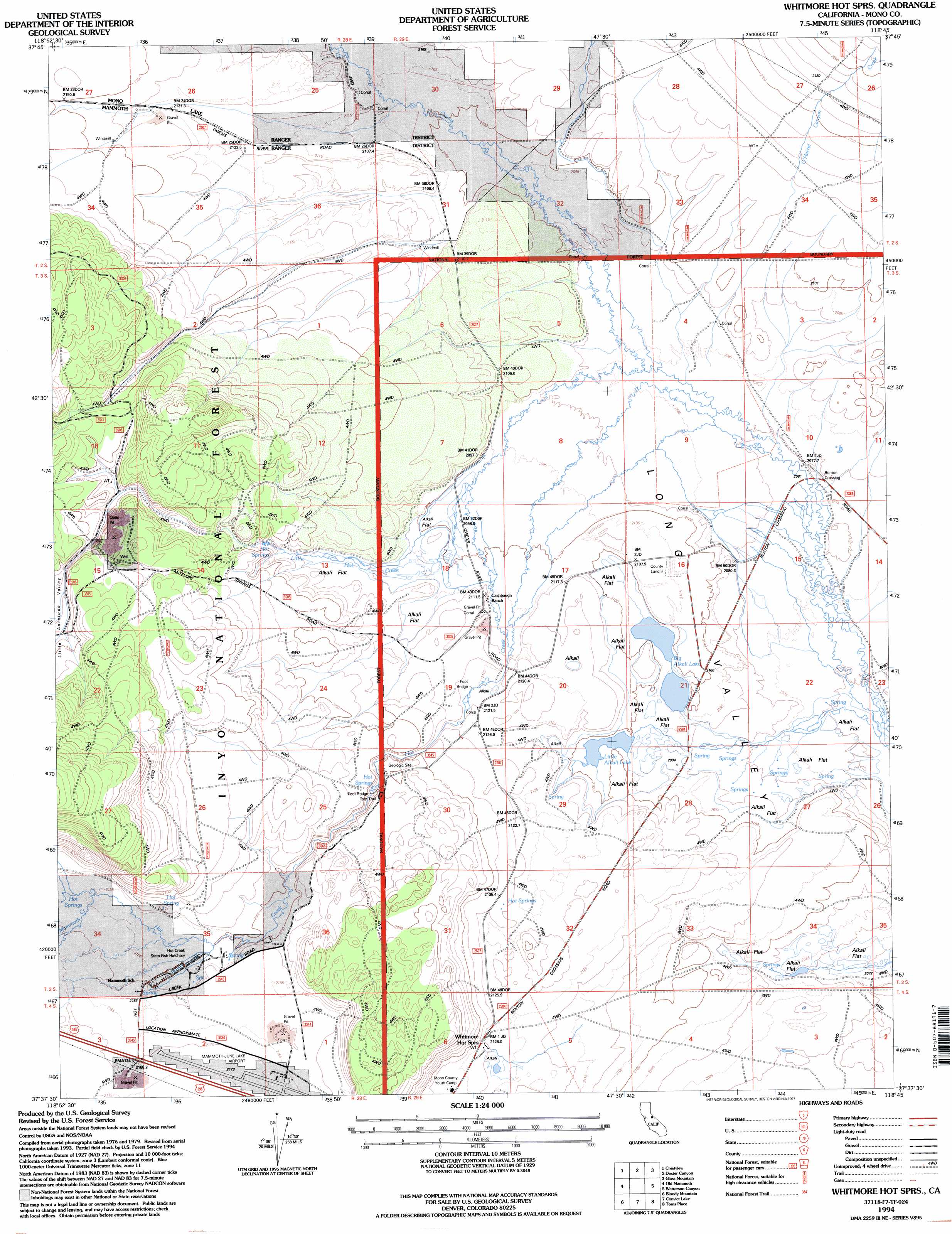
USGS Topo Quad 37118f7 - 1:24,000 scale
| Topo Map Name: | Whitmore Hot Springs |
| USGS Topo Quad ID: | 37118f7 |
| Print Size: | ca. 21 1/4" wide x 27" high |
| Southeast Coordinates: | 37.625° N latitude / 118.75° W longitude |
| Map Center Coordinates: | 37.6875° N latitude / 118.8125° W longitude |
| U.S. State: | CA |
| Filename: | o37118f7.jpg |
| Download Map JPG Image: | Whitmore Hot Springs topo map 1:24,000 scale |
| Map Type: | Topographic |
| Topo Series: | 7.5´ |
| Map Scale: | 1:24,000 |
| Source of Map Images: | United States Geological Survey (USGS) |
| Alternate Map Versions: |
Whitmore Hot Sprs CA 1983, updated 1983 Download PDF Buy paper map Whitmore Hot Sprs CA 1990, updated 1995 Download PDF Buy paper map Whitmore Hot Sprs CA 1994, updated 1997 Download PDF Buy paper map Whitmore Hot Springs CA 2012 Download PDF Buy paper map Whitmore Hot Springs CA 2015 Download PDF Buy paper map |
| FStopo: | US Forest Service topo Whitmore Hot Springs is available: Download FStopo PDF Download FStopo TIF |
1:24,000 Topo Quads surrounding Whitmore Hot Springs
Lee Vining |
Mono Mills |
Cowtrack Mountain |
Indian Meadows |
River Spring |
June Lake |
Crestview |
Dexter Canyon |
Glass Mountain |
Benton Hot Spirngs |
Mammoth Mountain |
Old Mammoth |
Whitmore Hot Springs |
Watterson Canyon |
Banner Ridge |
Crystal Crag |
Bloody Mountain |
Convict Lake |
Toms Place |
Casa Diablo Mountain |
Sharktooth Peak |
Graveyard Peak |
Mount Abbot |
Mount Morgan |
Rovana |
> Back to 37118e1 at 1:100,000 scale
> Back to 37118a1 at 1:250,000 scale
> Back to U.S. Topo Maps home
Whitmore Hot Springs topo map: Gazetteer
Whitmore Hot Springs: Airports
Mammoth-June Lake Airport elevation 2176m 7139′Whitmore Hot Springs: Basins
Long Valley elevation 2073m 6801′Whitmore Tub elevation 2130m 6988′
Whitmore Hot Springs: Lakes
Big Alkali Lake elevation 2097m 6879′Little Alkali Lake elevation 2100m 6889′
Whitmore Hot Springs: Mines
Clay Pit Mine elevation 2244m 7362′Whitmore Hot Springs: Populated Places
Benton Crossing elevation 2081m 6827′Whitmore Hot Springs elevation 2139m 7017′
Whitmore Hot Springs: Streams
Hot Creek elevation 2086m 6843′Little Hot Creek elevation 2101m 6893′
O'Harrel Canyon Creek elevation 2083m 6833′
Whitmore Hot Springs: Valleys
Little Antelope Valley elevation 2205m 7234′Whitmore Hot Springs digital topo map on disk
Buy this Whitmore Hot Springs topo map showing relief, roads, GPS coordinates and other geographical features, as a high-resolution digital map file on DVD: