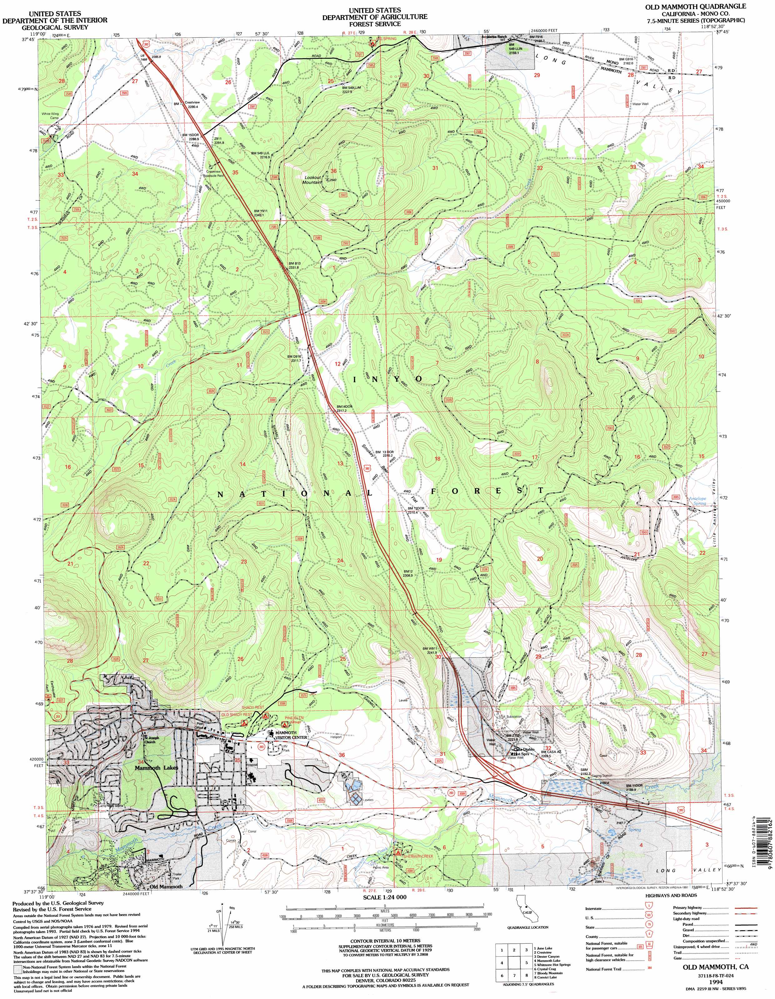
Old Mammoth Topo Map California
To zoom in, hover over the map of Old Mammoth
USGS Topo Quad 37118f8 - 1:24,000 scale
| Topo Map Name: | Old Mammoth |
| USGS Topo Quad ID: | 37118f8 |
| Print Size: | ca. 21 1/4" wide x 27" high |
| Southeast Coordinates: | 37.625° N latitude / 118.875° W longitude |
| Map Center Coordinates: | 37.6875° N latitude / 118.9375° W longitude |
| U.S. State: | CA |
| Filename: | o37118f8.jpg |
| Download Map JPG Image: | Old Mammoth topo map 1:24,000 scale |
| Map Type: | Topographic |
| Topo Series: | 7.5´ |
| Map Scale: | 1:24,000 |
| Source of Map Images: | United States Geological Survey (USGS) |
| Alternate Map Versions: |
Old Mammoth CA 1983, updated 1984 Download PDF Buy paper map Old Mammoth CA 1983, updated 1986 Download PDF Buy paper map Old Mammoth CA 1983, updated 1986 Download PDF Buy paper map Old Mammoth CA 1994, updated 1997 Download PDF Buy paper map Old Mammoth CA 2012 Download PDF Buy paper map Old Mammoth CA 2015 Download PDF Buy paper map |
| FStopo: | US Forest Service topo Old Mammoth is available: Download FStopo PDF Download FStopo TIF |
1:24,000 Topo Quads surrounding Old Mammoth
Mount Dana |
Lee Vining |
Mono Mills |
Cowtrack Mountain |
Indian Meadows |
Koip Peak |
June Lake |
Crestview |
Dexter Canyon |
Glass Mountain |
Mount Ritter |
Mammoth Mountain |
Old Mammoth |
Whitmore Hot Springs |
Watterson Canyon |
Cattle Mountain |
Crystal Crag |
Bloody Mountain |
Convict Lake |
Toms Place |
Balloon Dome |
Sharktooth Peak |
Graveyard Peak |
Mount Abbot |
Mount Morgan |
> Back to 37118e1 at 1:100,000 scale
> Back to 37118a1 at 1:250,000 scale
> Back to U.S. Topo Maps home
Old Mammoth topo map: Gazetteer
Old Mammoth: Craters
Long Valley Caldera elevation 2341m 7680′Old Mammoth: Flats
Smokey Bear Flat elevation 2315m 7595′Old Mammoth: Parks
Community Center Park elevation 2460m 8070′Mammoth Creek Park elevation 2395m 7857′
Shady Rest Park elevation 2370m 7775′
Valentine Reserve Ecological Study Area elevation 2471m 8106′
Old Mammoth: Populated Places
Mammoth Lakes elevation 2402m 7880′Old Mammoth elevation 2443m 8015′
Old Mammoth: Post Offices
Mammoth Lakes Post Office elevation 2400m 7874′Old Mammoth: Springs
Antelope Spring elevation 2192m 7191′Old Mammoth: Streams
Dry Creek elevation 2162m 7093′Glass Creek elevation 2287m 7503′
Laurel Creek elevation 2186m 7171′
Mammoth Creek elevation 2202m 7224′
Sherwin Creek elevation 2300m 7545′
Old Mammoth: Summits
Dry Creek Knoll elevation 2695m 8841′Earthquake Dome elevation 2850m 9350′
Gilbert Peak elevation 2611m 8566′
Lookout Mountain elevation 2543m 8343′
Mammoth Knolls elevation 2675m 8776′
Old Mammoth digital topo map on disk
Buy this Old Mammoth topo map showing relief, roads, GPS coordinates and other geographical features, as a high-resolution digital map file on DVD: