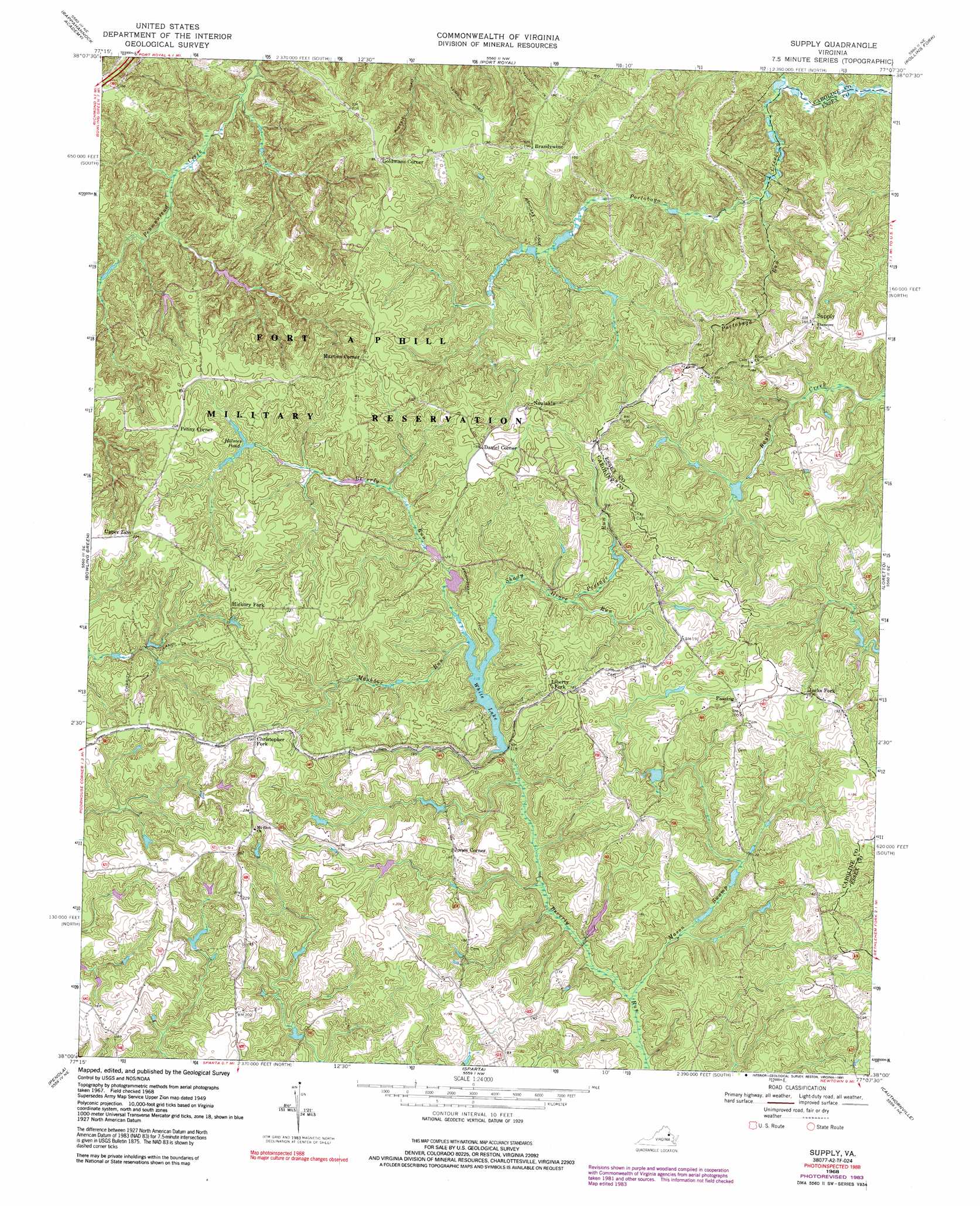
Supply Topo Map Virginia
To zoom in, hover over the map of Supply
USGS Topo Quad 38077a2 - 1:24,000 scale
| Topo Map Name: | Supply |
| USGS Topo Quad ID: | 38077a2 |
| Print Size: | ca. 21 1/4" wide x 27" high |
| Southeast Coordinates: | 38° N latitude / 77.125° W longitude |
| Map Center Coordinates: | 38.0625° N latitude / 77.1875° W longitude |
| U.S. State: | VA |
| Filename: | o38077a2.jpg |
| Download Map JPG Image: | Supply topo map 1:24,000 scale |
| Map Type: | Topographic |
| Topo Series: | 7.5´ |
| Map Scale: | 1:24,000 |
| Source of Map Images: | United States Geological Survey (USGS) |
| Alternate Map Versions: |
Upper Zion VA 1952 Download PDF Buy paper map Upper Zion VA 1964 Download PDF Buy paper map Supply VA 1968, updated 1971 Download PDF Buy paper map Supply VA 1968, updated 1984 Download PDF Buy paper map Supply VA 1968, updated 1991 Download PDF Buy paper map Supply VA 1968, updated 2000 Download PDF Buy paper map Supply VA 2011 Download PDF Buy paper map Supply VA 2013 Download PDF Buy paper map Supply VA 2016 Download PDF Buy paper map |
1:24,000 Topo Quads surrounding Supply
Fredericksburg |
Passapatanzy |
King George |
Dahlgren |
Colonial Beach North |
Guinea |
Rappahannock Academy |
Port Royal |
Rollins Fork |
Colonial Beach South |
Woodford |
Bowling Green |
Supply |
Loretto |
Champlain |
Ruther Glen |
Penola |
Sparta |
Cauthornville |
Mount Landing |
Ashland |
Hanover |
Beulahville |
Aylett |
Millers Tavern |
> Back to 38077a1 at 1:100,000 scale
> Back to 38076a1 at 1:250,000 scale
> Back to U.S. Topo Maps home
Supply topo map: Gazetteer
Supply: Dams
P D Pitts Dam elevation 30m 98′White Lake Dam elevation 36m 118′
Supply: Populated Places
Brandywine elevation 59m 193′Christopher Fork elevation 70m 229′
Daniel Corner elevation 61m 200′
Goldmans Corner elevation 61m 200′
Hickory Fork elevation 67m 219′
Jacks Fork elevation 50m 164′
Jones Corner elevation 57m 187′
Liberty Fork elevation 62m 203′
Martins Corner elevation 64m 209′
Naulakla elevation 61m 200′
Penny Corner elevation 64m 209′
Upper Zion elevation 68m 223′
Whites (historical) elevation 52m 170′
Supply: Reservoirs
Holmes Pond elevation 45m 147′Jones Pond elevation 44m 144′
White Lake elevation 58m 190′
White Lake elevation 36m 118′
Supply: Streams
Mashbox Run elevation 35m 114′Mason Swamp elevation 29m 95′
Portage Run elevation 40m 131′
Portobago Run elevation 13m 42′
Shady Grove Run elevation 36m 118′
Supply: Trails
Broomstraw Trail elevation 47m 154′Supply digital topo map on disk
Buy this Supply topo map showing relief, roads, GPS coordinates and other geographical features, as a high-resolution digital map file on DVD:
Atlantic Coast (NY, NJ, PA, DE, MD, VA, NC)
Buy digital topo maps: Atlantic Coast (NY, NJ, PA, DE, MD, VA, NC)
 map DVD")