Lake Sherwood Topo Map West Virginia
To zoom in, hover over the map of Lake Sherwood
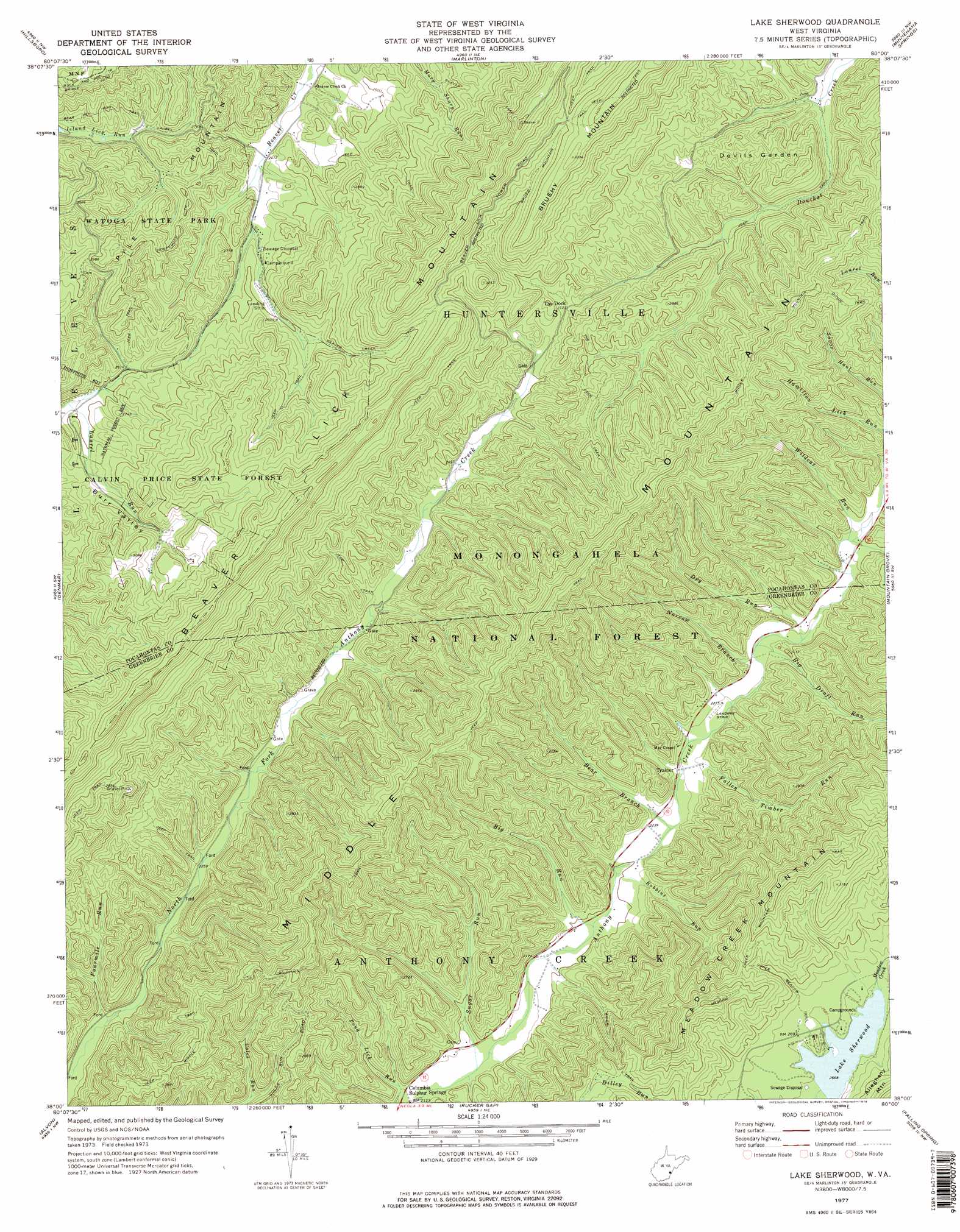
USGS Topo Quad 38080a1 - 1:24,000 scale
| Topo Map Name: | Lake Sherwood |
| USGS Topo Quad ID: | 38080a1 |
| Print Size: | ca. 21 1/4" wide x 27" high |
| Southeast Coordinates: | 38° N latitude / 80° W longitude |
| Map Center Coordinates: | 38.0625° N latitude / 80.0625° W longitude |
| U.S. State: | WV |
| Filename: | o38080a1.jpg |
| Download Map JPG Image: | Lake Sherwood topo map 1:24,000 scale |
| Map Type: | Topographic |
| Topo Series: | 7.5´ |
| Map Scale: | 1:24,000 |
| Source of Map Images: | United States Geological Survey (USGS) |
| Alternate Map Versions: |
Lake Sherwood WV 1977, updated 1978 Download PDF Buy paper map Lake Sherwood WV 1995, updated 1998 Download PDF Buy paper map Lake Sherwood WV 2011 Download PDF Buy paper map Lake Sherwood WV 2014 Download PDF Buy paper map Lake Sherwood WV 2016 Download PDF Buy paper map |
| FStopo: | US Forest Service topo Lake Sherwood is available: Download FStopo PDF Download FStopo TIF |
1:24,000 Topo Quads surrounding Lake Sherwood
Webster Springs Se |
Woodrow |
Edray |
Clover Lick |
Paddy Knob |
Lobelia |
Hillsboro |
Marlinton |
Minnehaha Springs |
Sunrise |
Droop |
Denmar |
Lake Sherwood |
Mountain Grove |
Warm Springs |
Anthony |
Alvon |
Rucker Gap |
Falling Spring |
Healing Springs |
White Sulphur Springs |
Jerrys Run |
Callaghan |
Covington |
Clifton Forge |
> Back to 38080a1 at 1:100,000 scale
> Back to 38080a1 at 1:250,000 scale
> Back to U.S. Topo Maps home
Lake Sherwood topo map: Gazetteer
Lake Sherwood: Areas
Devils Garden elevation 829m 2719′Lake Sherwood: Dams
Lake Sherwood Dam elevation 814m 2670′Watoga Lake Dam elevation 808m 2650′
Lake Sherwood: Parks
Lake Sherwood Recreation Area elevation 818m 2683′Lake Sherwood: Populated Places
Burr elevation 911m 2988′Trainer elevation 683m 2240′
Lake Sherwood: Reservoirs
Lake Sherwood elevation 816m 2677′Lake Sherwood elevation 814m 2670′
Watoga Lake elevation 808m 2650′
Lake Sherwood: Ridges
Meadow Creek Mountain elevation 975m 3198′Middle Mountain elevation 1009m 3310′
Lake Sherwood: Streams
Bear Branch elevation 676m 2217′Big Draft Run elevation 699m 2293′
Big Run elevation 664m 2178′
Dilley Run elevation 840m 2755′
Dry Run elevation 703m 2306′
Fallen Timber Run elevation 681m 2234′
Fourmile Run elevation 662m 2171′
Laurel Run elevation 721m 2365′
Narrow Branch elevation 697m 2286′
Robbins Run elevation 671m 2201′
Sugar Run elevation 653m 2142′
Wildcat Run elevation 717m 2352′
Lake Sherwood: Summits
White Rocks elevation 1102m 3615′Lake Sherwood: Trails
Beaver Creek Trail elevation 847m 2778′Beaver Trail elevation 854m 2801′
Honey Moon Trail elevation 864m 2834′
Laurel Trail elevation 821m 2693′
Meadow Creek Mountain Trail elevation 934m 3064′
Middle Mountain Trail elevation 1026m 3366′
Rider Trail elevation 841m 2759′
The Dock Trail elevation 889m 2916′
Upper Meadow Trail elevation 844m 2769′
Lake Sherwood: Valleys
Burr Valley elevation 788m 2585′May Hollow elevation 701m 2299′
Lake Sherwood digital topo map on disk
Buy this Lake Sherwood topo map showing relief, roads, GPS coordinates and other geographical features, as a high-resolution digital map file on DVD:
Western Virginia & Southern West Virginia
Buy digital topo maps: Western Virginia & Southern West Virginia