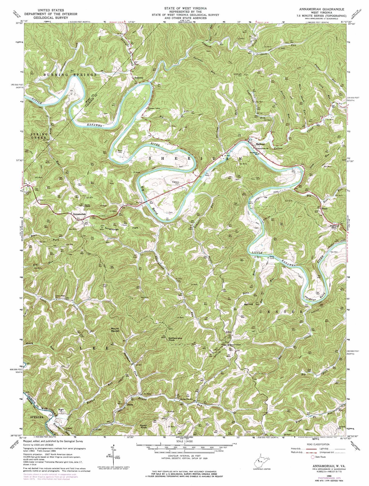
Annamoriah Topo Map West Virginia
To zoom in, hover over the map of Annamoriah
USGS Topo Quad 38081h2 - 1:24,000 scale
| Topo Map Name: | Annamoriah |
| USGS Topo Quad ID: | 38081h2 |
| Print Size: | ca. 21 1/4" wide x 27" high |
| Southeast Coordinates: | 38.875° N latitude / 81.125° W longitude |
| Map Center Coordinates: | 38.9375° N latitude / 81.1875° W longitude |
| U.S. State: | WV |
| Filename: | o38081h2.jpg |
| Download Map JPG Image: | Annamoriah topo map 1:24,000 scale |
| Map Type: | Topographic |
| Topo Series: | 7.5´ |
| Map Scale: | 1:24,000 |
| Source of Map Images: | United States Geological Survey (USGS) |
| Alternate Map Versions: |
Annamoriah WV 1966, updated 1968 Download PDF Buy paper map Annamoriah WV 1966, updated 1977 Download PDF Buy paper map Annamoriah WV 2011 Download PDF Buy paper map Annamoriah WV 2014 Download PDF Buy paper map Annamoriah WV 2016 Download PDF Buy paper map |
1:24,000 Topo Quads surrounding Annamoriah
Kanawha |
Petroleum |
Cairo |
Harrisville |
Pullman |
Elizabeth |
Girta |
Macfarlan |
Smithville |
Burnt House |
Reedy |
Burning Springs |
Annamoriah |
Grantsville |
Tanner |
Peniel |
Spencer |
Arnoldsburg |
Millstone |
Normantown |
Walton |
Looneyville |
Tariff |
Chloe |
Rosedale |
> Back to 38081e1 at 1:100,000 scale
> Back to 38080a1 at 1:250,000 scale
> Back to U.S. Topo Maps home
Annamoriah topo map: Gazetteer
Annamoriah: Bends
Big Bend elevation 212m 695′Hardman Bend elevation 209m 685′
Annamoriah: Crossings
Bells Ford elevation 200m 656′Annamoriah: Flats
Annamoriah Flats elevation 305m 1000′Annamoriah: Parks
Coopers Park elevation 298m 977′Annamoriah: Populated Places
Annamoriah elevation 303m 994′Bigbend elevation 208m 682′
Cremo elevation 216m 708′
Creston Flats elevation 323m 1059′
Joker elevation 336m 1102′
Purdy elevation 214m 702′
Annamoriah: Post Offices
Annamoriah Post Office elevation 298m 977′Bigbend Post Office elevation 207m 679′
Annamoriah: Streams
Annamoriah Run elevation 199m 652′Bee Creek elevation 210m 688′
Bee Run elevation 203m 666′
Bell Run elevation 207m 679′
Bells Run elevation 199m 652′
Big Root Run elevation 198m 649′
Big Run elevation 197m 646′
Browns Run elevation 204m 669′
Buck Shuck Run elevation 207m 679′
Fisher Run elevation 212m 695′
Gunwale Run elevation 202m 662′
Hardman Fork elevation 220m 721′
Katy Run elevation 195m 639′
Leading Creek elevation 196m 643′
Lemuels Run elevation 203m 666′
Lick Run elevation 211m 692′
Lick Run elevation 197m 646′
Little Rowles Run elevation 204m 669′
Rowles Run elevation 202m 662′
Stocking Run elevation 197m 646′
Straight Creek elevation 196m 643′
Sugarcamp Run elevation 198m 649′
Trippett Run elevation 212m 695′
Yellow Creek elevation 197m 646′
Annamoriah: Summits
Bell Hill elevation 323m 1059′Mount Beulah elevation 371m 1217′
Nighcut Hill elevation 315m 1033′
Palsor Knob elevation 380m 1246′
Rattlesnake Knob elevation 393m 1289′
Annamoriah digital topo map on disk
Buy this Annamoriah topo map showing relief, roads, GPS coordinates and other geographical features, as a high-resolution digital map file on DVD:
Western Virginia & Southern West Virginia
Buy digital topo maps: Western Virginia & Southern West Virginia