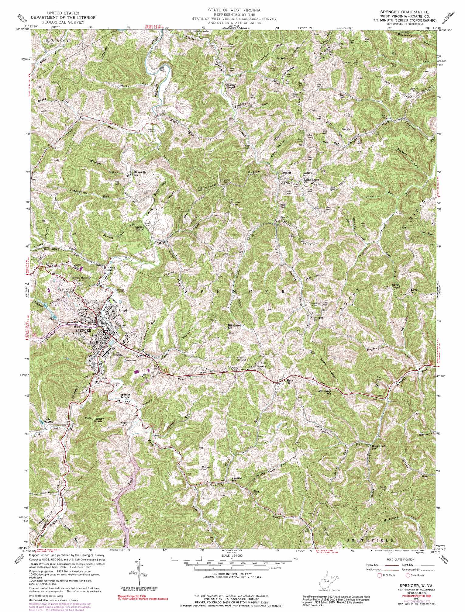
Spencer Topo Map West Virginia
To zoom in, hover over the map of Spencer
USGS Topo Quad 38081g3 - 1:24,000 scale
| Topo Map Name: | Spencer |
| USGS Topo Quad ID: | 38081g3 |
| Print Size: | ca. 21 1/4" wide x 27" high |
| Southeast Coordinates: | 38.75° N latitude / 81.25° W longitude |
| Map Center Coordinates: | 38.8125° N latitude / 81.3125° W longitude |
| U.S. State: | WV |
| Filename: | o38081g3.jpg |
| Download Map JPG Image: | Spencer topo map 1:24,000 scale |
| Map Type: | Topographic |
| Topo Series: | 7.5´ |
| Map Scale: | 1:24,000 |
| Source of Map Images: | United States Geological Survey (USGS) |
| Alternate Map Versions: |
Spencer WV 1957, updated 1959 Download PDF Buy paper map Spencer WV 1957, updated 1977 Download PDF Buy paper map Spencer WV 1957, updated 1991 Download PDF Buy paper map Spencer WV 2011 Download PDF Buy paper map Spencer WV 2014 Download PDF Buy paper map Spencer WV 2016 Download PDF Buy paper map |
1:24,000 Topo Quads surrounding Spencer
Rockport |
Elizabeth |
Girta |
Macfarlan |
Smithville |
Liverpool |
Reedy |
Burning Springs |
Annamoriah |
Grantsville |
Gay |
Peniel |
Spencer |
Arnoldsburg |
Millstone |
Kentuck |
Walton |
Looneyville |
Tariff |
Chloe |
Romance |
Kettle |
Clio |
Newton |
Ivydale |
> Back to 38081e1 at 1:100,000 scale
> Back to 38080a1 at 1:250,000 scale
> Back to U.S. Topo Maps home
Spencer topo map: Gazetteer
Spencer: Airports
Slate Run Airport elevation 304m 997′Spencer: Dams
Methodist Church Camp Lake Number Two Dam elevation 208m 682′Miletree Run Dam Number One elevation 241m 790′
Miletree Run Number Two Dam elevation 229m 751′
Spring Creek-Charles Fork Number 17 Dam elevation 238m 780′
Spencer: Parks
Alford Park elevation 219m 718′Washington Park elevation 225m 738′
Spencer: Populated Places
Alvord elevation 237m 777′Bartlett Addition elevation 252m 826′
Bowers Hill elevation 326m 1069′
Campbell Addition elevation 276m 905′
East Meadows elevation 288m 944′
Graux elevation 255m 836′
Green Acres elevation 285m 935′
Hassock Addition elevation 253m 830′
Holswade Addition elevation 223m 731′
Morford elevation 272m 892′
Nancy Run elevation 220m 721′
Oak Drive Subdivision elevation 285m 935′
Quiet Vale elevation 279m 915′
Schilling elevation 232m 761′
Schilling Addition elevation 225m 738′
Schoolhouse Hill Addition elevation 247m 810′
Spencer elevation 228m 748′
Triplett elevation 234m 767′
Wellington elevation 216m 708′
Spencer: Reservoirs
Lake Trotter elevation 235m 770′Miletree Lakes elevation 242m 793′
Spencer: Ridges
Craig Ridge elevation 345m 1131′Egypt Ridge elevation 349m 1145′
Mulberry Ridge elevation 309m 1013′
Spencer: Streams
Bee Run elevation 235m 770′Boggs Fork elevation 239m 784′
Boggs Run elevation 212m 695′
Brushy Fork elevation 230m 754′
Buffington Run elevation 222m 728′
Burned House Run elevation 218m 715′
Cedarpoint Run elevation 212m 695′
Charles Fork elevation 224m 734′
Danger Run elevation 231m 757′
Daniels Run elevation 225m 738′
Drift Run elevation 208m 682′
Fall Run elevation 235m 770′
Fodderpen Run elevation 221m 725′
Goff Run elevation 219m 718′
Hedges Fork elevation 247m 810′
Hicks Run elevation 209m 685′
Island Run elevation 208m 682′
Janes Run elevation 243m 797′
Johns Run elevation 247m 810′
Laurel Run elevation 227m 744′
Left Fork Little Spring Creek elevation 214m 702′
Left Fork Spring Creek elevation 221m 725′
Lick Fork elevation 221m 725′
Miletree Run elevation 226m 741′
Miller Run elevation 217m 711′
Nancy Run elevation 216m 708′
Peters Cave Run elevation 242m 793′
Plum Run elevation 216m 708′
Pretty Farm Run elevation 247m 810′
Rafter Run elevation 215m 705′
Right Fork Island Run elevation 229m 751′
Right Fork Little Spring Creek elevation 237m 777′
Right Fork Miller Run elevation 218m 715′
Right Fork Spring Creek elevation 222m 728′
Rock Fork elevation 231m 757′
Slate Run elevation 231m 757′
Spruce Run elevation 233m 764′
Tanner Run elevation 216m 708′
Vandale Fork elevation 228m 748′
Wildcat Run elevation 212m 695′
Spencer: Summits
College Hill elevation 268m 879′Turkey Knob elevation 363m 1190′
Spencer: Valleys
Ball Hollow elevation 223m 731′Blosser Hollow elevation 213m 698′
Hut Hollow elevation 231m 757′
Knotts Hollow elevation 253m 830′
Laurel Hollow elevation 247m 810′
Steele Hollow elevation 229m 751′
Spencer digital topo map on disk
Buy this Spencer topo map showing relief, roads, GPS coordinates and other geographical features, as a high-resolution digital map file on DVD:
Western Virginia & Southern West Virginia
Buy digital topo maps: Western Virginia & Southern West Virginia