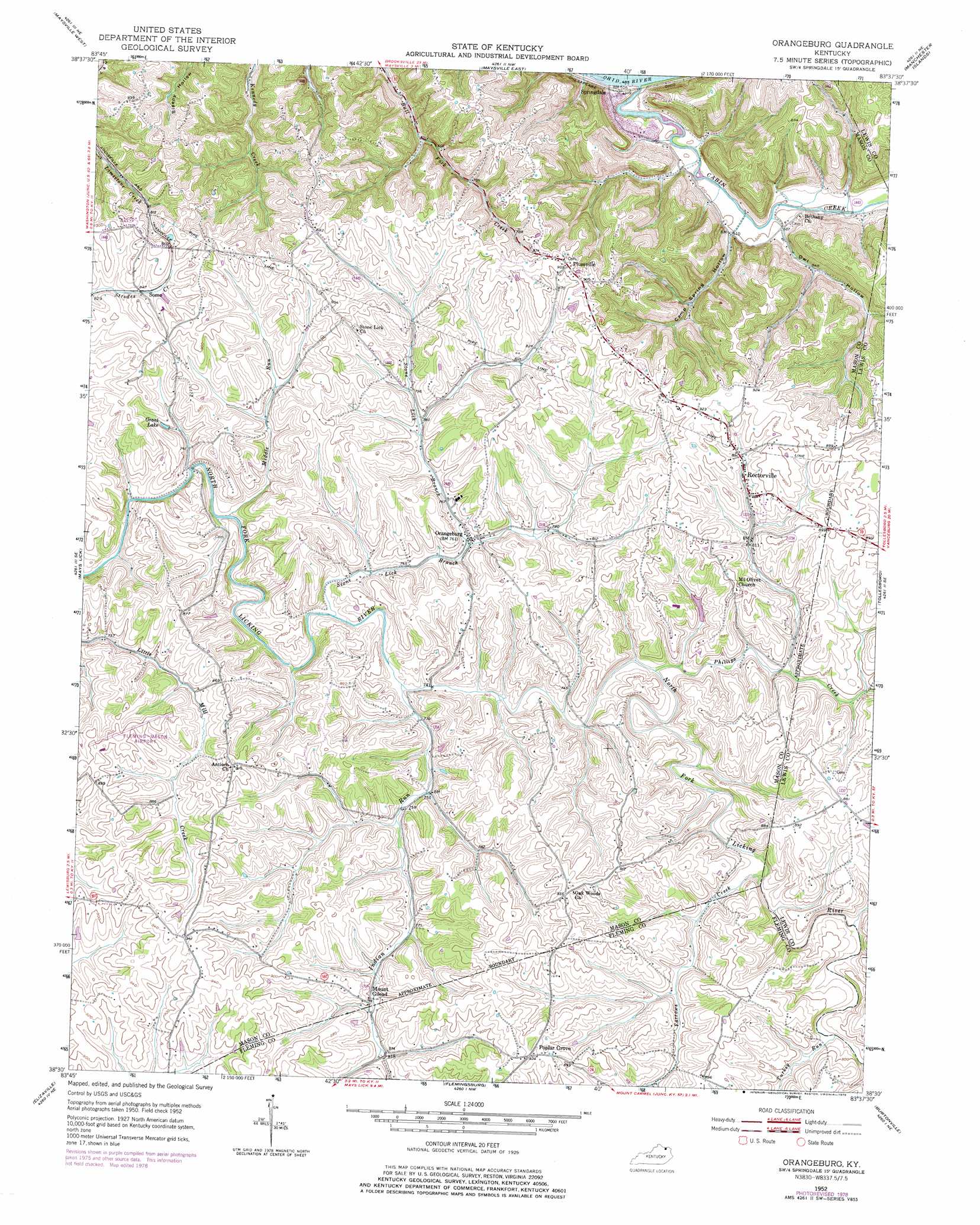
Orangeburg Topo Map Kentucky
To zoom in, hover over the map of Orangeburg
USGS Topo Quad 38083e6 - 1:24,000 scale
| Topo Map Name: | Orangeburg |
| USGS Topo Quad ID: | 38083e6 |
| Print Size: | ca. 21 1/4" wide x 27" high |
| Southeast Coordinates: | 38.5° N latitude / 83.625° W longitude |
| Map Center Coordinates: | 38.5625° N latitude / 83.6875° W longitude |
| U.S. State: | KY |
| Filename: | o38083e6.jpg |
| Download Map JPG Image: | Orangeburg topo map 1:24,000 scale |
| Map Type: | Topographic |
| Topo Series: | 7.5´ |
| Map Scale: | 1:24,000 |
| Source of Map Images: | United States Geological Survey (USGS) |
| Alternate Map Versions: |
Orangeburg KY 1952, updated 1954 Download PDF Buy paper map Orangeburg KY 1952, updated 1969 Download PDF Buy paper map Orangeburg KY 1952, updated 1978 Download PDF Buy paper map Orangeburg KY 2010 Download PDF Buy paper map Orangeburg KY 2013 Download PDF Buy paper map Orangeburg KY 2016 Download PDF Buy paper map |
1:24,000 Topo Quads surrounding Orangeburg
Higginsport |
Russellville |
Decatur |
West Union |
Lynx |
Germantown |
Maysville West |
Maysville East |
Manchester Islands |
Concord |
Sardis |
Mays Lick |
Orangeburg |
Tollesboro |
Charters |
Cowan |
Elizaville |
Flemingsburg |
Burtonville |
Stricklett |
Moorefield |
Sherburne |
Hillsboro |
Plummers Landing |
Cranston |
> Back to 38083e1 at 1:100,000 scale
> Back to 38082a1 at 1:250,000 scale
> Back to U.S. Topo Maps home
Orangeburg topo map: Gazetteer
Orangeburg: Airports
Fleming-Mason Airport elevation 278m 912′Orangeburg: Populated Places
Mount Gilead elevation 244m 800′Orangeburg elevation 236m 774′
Plumville elevation 281m 921′
Poplar Grove elevation 286m 938′
Rectorville elevation 260m 853′
Somo elevation 258m 846′
Springdale elevation 160m 524′
Taylors Mill elevation 223m 731′
Orangeburg: Post Offices
Bernard Post Office (historical) elevation 171m 561′Farrows Mill Post Office (historical) elevation 236m 774′
Mount Gilead Post Office (historical) elevation 231m 757′
Plumville Post Office (historical) elevation 279m 915′
Rectorville Post Office (historical) elevation 259m 849′
Springdale Post Office (historical) elevation 162m 531′
Orangeburg: Reservoirs
Grant Lake elevation 244m 800′Orangeburg: Streams
Bairds Run elevation 147m 482′Cabin Creek elevation 147m 482′
Farrows Creek elevation 223m 731′
Indian Run elevation 226m 741′
Middle Run elevation 220m 721′
Phillips Creek elevation 224m 734′
Stone Lick Branch elevation 223m 731′
Turkey Run elevation 228m 748′
Orangeburg: Summits
Sycamore Hill elevation 267m 875′Orangeburg: Valleys
Camp Spring Hollow elevation 153m 501′Owl Hollow elevation 156m 511′
Orangeburg digital topo map on disk
Buy this Orangeburg topo map showing relief, roads, GPS coordinates and other geographical features, as a high-resolution digital map file on DVD:
Western Virginia & Southern West Virginia
Buy digital topo maps: Western Virginia & Southern West Virginia