Scotland Topo Map Indiana
To zoom in, hover over the map of Scotland
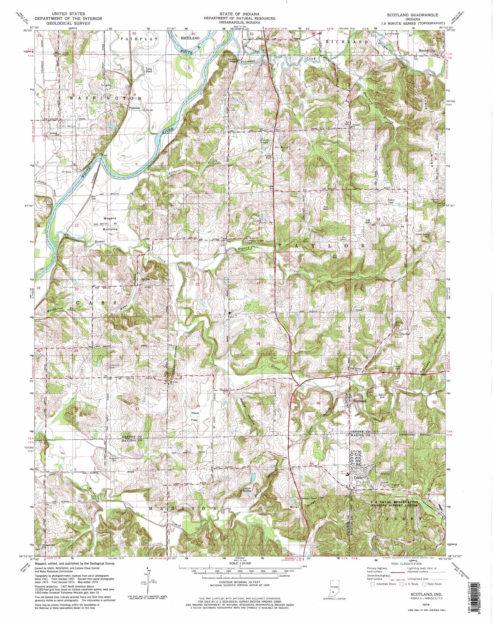
USGS Topo Quad 38086h8 - 1:24,000 scale
| Topo Map Name: | Scotland |
| USGS Topo Quad ID: | 38086h8 |
| Print Size: | ca. 21 1/4" wide x 27" high |
| Southeast Coordinates: | 38.875° N latitude / 86.875° W longitude |
| Map Center Coordinates: | 38.9375° N latitude / 86.9375° W longitude |
| U.S. State: | IN |
| Filename: | o38086h8.jpg |
| Download Map JPG Image: | Scotland topo map 1:24,000 scale |
| Map Type: | Topographic |
| Topo Series: | 7.5´ |
| Map Scale: | 1:24,000 |
| Source of Map Images: | United States Geological Survey (USGS) |
| Alternate Map Versions: |
Scotland IN 1957, updated 1958 Download PDF Buy paper map Scotland IN 1957, updated 1970 Download PDF Buy paper map Scotland IN 1979, updated 1979 Download PDF Buy paper map Scotland IN 1979, updated 1979 Download PDF Buy paper map Scotland IN 1979, updated 1979 Download PDF Buy paper map Scotland IN 2010 Download PDF Buy paper map Scotland IN 2013 Download PDF Buy paper map Scotland IN 2016 Download PDF Buy paper map |
1:24,000 Topo Quads surrounding Scotland
Jasonville |
Coal City |
Arney |
Freedom |
Whitehall |
Linton |
Switz City |
Bloomfield |
Solsberry |
Stanford |
Sandborn |
Lyons |
Scotland |
Koleen |
Owensburg |
Plainville |
Epsom |
Odon |
Indian Springs |
Williams |
Washington |
Montgomery |
Loogootee |
Shoals |
Huron |
> Back to 38086e1 at 1:100,000 scale
> Back to 38086a1 at 1:250,000 scale
> Back to U.S. Topo Maps home
Scotland topo map: Gazetteer
Scotland: Bends
Bogard Bottoms elevation 149m 488′Scotland: Flats
Maple Flats elevation 167m 547′Scotland: Lakes
Long Pond elevation 150m 492′Scotland: Populated Places
Crane elevation 187m 613′Mineral City elevation 157m 515′
Plummer elevation 151m 495′
Scotland elevation 187m 613′
Scotland: Ridges
Briar Ridge elevation 213m 698′Feutz Ridge elevation 220m 721′
Scotland: Streams
Bogard Creek elevation 150m 492′Burcham Branch elevation 149m 488′
Culpepper Brook elevation 165m 541′
Doans Creek elevation 147m 482′
Dowden Branch elevation 169m 554′
Gilbert Creek elevation 146m 479′
Letsinger Branch elevation 152m 498′
Plummer Creek elevation 148m 485′
Richland Creek elevation 149m 488′
Rocky Branch elevation 156m 511′
Stone Branch elevation 160m 524′
Scotland: Summits
Jolliff Rocks elevation 181m 593′Sand Hill elevation 194m 636′
Scotland: Valleys
Bear Hollow elevation 149m 488′Goose Hollow elevation 161m 528′
Opossum Hollow elevation 152m 498′
Scotland digital topo map on disk
Buy this Scotland topo map showing relief, roads, GPS coordinates and other geographical features, as a high-resolution digital map file on DVD: