Lyons Topo Map Indiana
To zoom in, hover over the map of Lyons
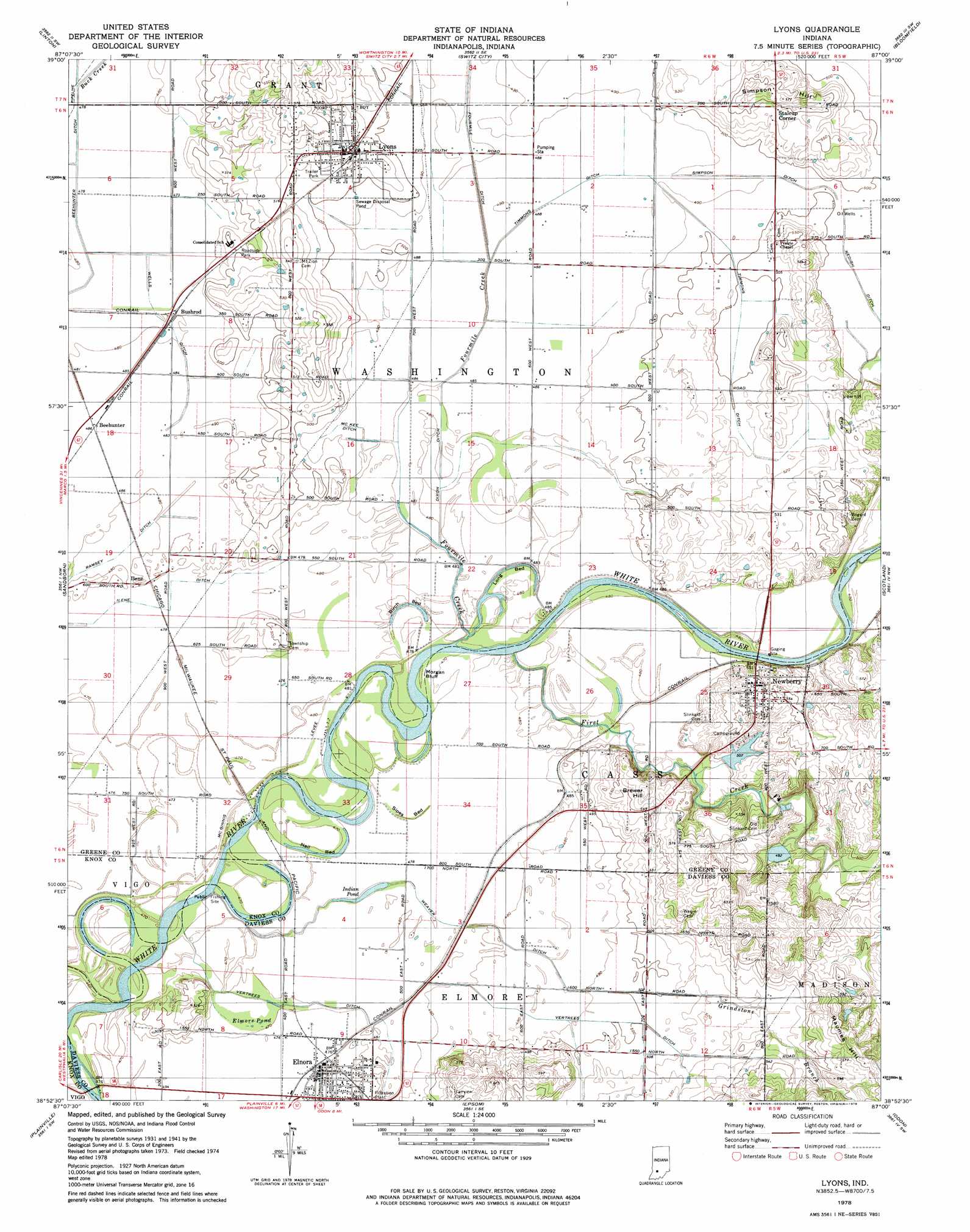
USGS Topo Quad 38087h1 - 1:24,000 scale
| Topo Map Name: | Lyons |
| USGS Topo Quad ID: | 38087h1 |
| Print Size: | ca. 21 1/4" wide x 27" high |
| Southeast Coordinates: | 38.875° N latitude / 87° W longitude |
| Map Center Coordinates: | 38.9375° N latitude / 87.0625° W longitude |
| U.S. State: | IN |
| Filename: | o38087h1.jpg |
| Download Map JPG Image: | Lyons topo map 1:24,000 scale |
| Map Type: | Topographic |
| Topo Series: | 7.5´ |
| Map Scale: | 1:24,000 |
| Source of Map Images: | United States Geological Survey (USGS) |
| Alternate Map Versions: |
Lyons IN 1943 Download PDF Buy paper map Lyons IN 1958, updated 1959 Download PDF Buy paper map Lyons IN 1978, updated 1979 Download PDF Buy paper map Lyons IN 1978, updated 1979 Download PDF Buy paper map Lyons IN 2011 Download PDF Buy paper map Lyons IN 2013 Download PDF Buy paper map Lyons IN 2016 Download PDF Buy paper map |
1:24,000 Topo Quads surrounding Lyons
Hymera |
Jasonville |
Coal City |
Arney |
Freedom |
Dugger |
Linton |
Switz City |
Bloomfield |
Solsberry |
Bucktown |
Sandborn |
Lyons |
Scotland |
Koleen |
Bicknell |
Plainville |
Epsom |
Odon |
Indian Springs |
Wheatland |
Washington |
Montgomery |
Loogootee |
Shoals |
> Back to 38087e1 at 1:100,000 scale
> Back to 38086a1 at 1:250,000 scale
> Back to U.S. Topo Maps home
Lyons topo map: Gazetteer
Lyons: Basins
Birch Bed elevation 146m 479′Long Bed elevation 146m 479′
Nail Bed elevation 143m 469′
Sipes Bed elevation 143m 469′
Lyons: Canals
Beehunter Ditch elevation 143m 469′Dixon Ditch elevation 146m 479′
Ilene Ditch elevation 146m 479′
Mc Kee Ditch elevation 146m 479′
Nedigh Ditch elevation 149m 488′
Ramsey Ditch elevation 146m 479′
Simpson Ditch elevation 149m 488′
Timmons Ditch elevation 152m 498′
Vertrees Ditch elevation 146m 479′
Weaver Ditch elevation 146m 479′
Wells Ditch elevation 146m 479′
Lyons: Cliffs
Morgan Hill elevation 142m 465′Lyons: Lakes
Indian Pond elevation 142m 465′Lyons: Populated Places
Beehunter elevation 148m 485′Bushrod elevation 146m 479′
Elnora elevation 146m 479′
Ilene elevation 147m 482′
Lyons elevation 162m 531′
Newberry elevation 168m 551′
Stalcup Corner elevation 166m 544′
Lyons: Streams
Buck Creek elevation 143m 469′First Creek elevation 140m 459′
Fourmile Creek elevation 144m 472′
Grindstone Branch elevation 143m 469′
Woodhouse Branch elevation 141m 462′
Lyons: Summits
Brewer Hill elevation 180m 590′Maumee Hill elevation 194m 636′
Simpson Hill elevation 175m 574′
Lyons: Swamps
Elmore Pond elevation 143m 469′Lyons digital topo map on disk
Buy this Lyons topo map showing relief, roads, GPS coordinates and other geographical features, as a high-resolution digital map file on DVD: