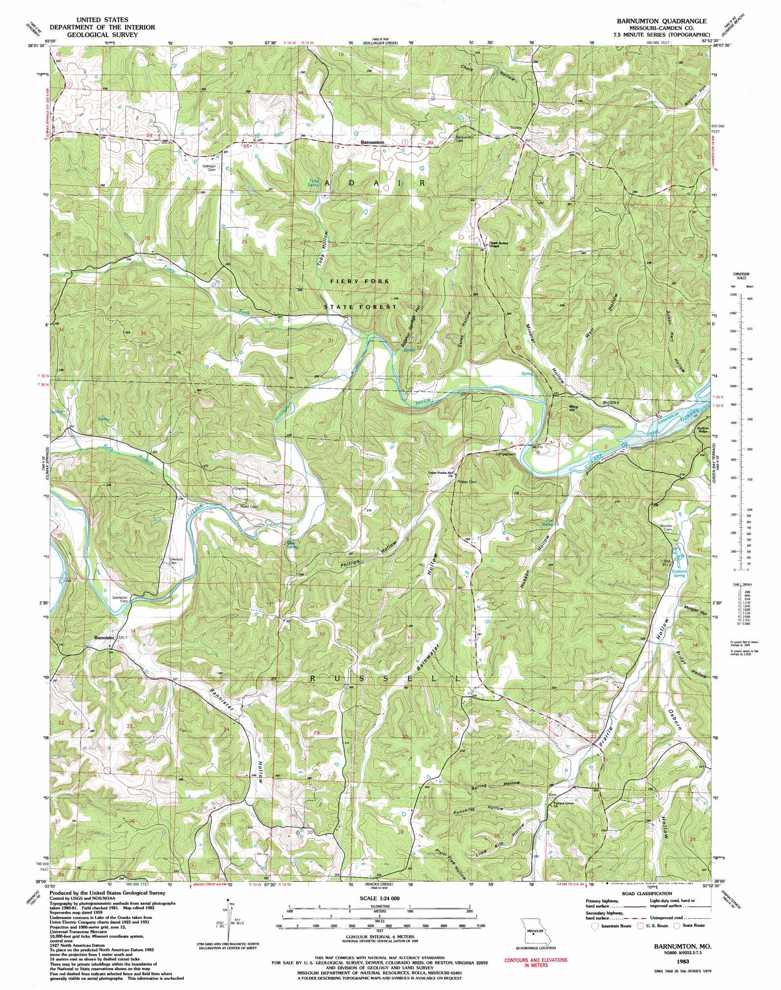
Barnumton Topo Map Missouri
To zoom in, hover over the map of Barnumton
USGS Topo Quad 38092a8 - 1:24,000 scale
| Topo Map Name: | Barnumton |
| USGS Topo Quad ID: | 38092a8 |
| Print Size: | ca. 21 1/4" wide x 27" high |
| Southeast Coordinates: | 38° N latitude / 92.875° W longitude |
| Map Center Coordinates: | 38.0625° N latitude / 92.9375° W longitude |
| U.S. State: | MO |
| Filename: | o38092a8.jpg |
| Download Map JPG Image: | Barnumton topo map 1:24,000 scale |
| Map Type: | Topographic |
| Topo Series: | 7.5´ |
| Map Scale: | 1:24,000 |
| Source of Map Images: | United States Geological Survey (USGS) |
| Alternate Map Versions: |
Barnumton MO 1935 Download PDF Buy paper map Barnumton MO 1957, updated 1957 Download PDF Buy paper map Barnumton MO 1959, updated 1960 Download PDF Buy paper map Barnumton MO 1959, updated 1973 Download PDF Buy paper map Barnumton MO 1983, updated 1983 Download PDF Buy paper map Barnumton MO 2011 Download PDF Buy paper map Barnumton MO 2015 Download PDF Buy paper map |
1:24,000 Topo Quads surrounding Barnumton
Lakeview Heights |
Boylers Mill |
Proctor Creek |
Gravois Mills |
Rocky Mount |
Edwards |
Knobby |
Bollinger Creek |
Sunrise Beach |
Lake Ozark |
Cross Timbers |
Climax Springs |
Barnumton |
Green Bay Terrace |
Camdenton |
Preston |
Branch |
Macks Creek |
Hahatonka |
Decaturville |
Urbana |
Tunas |
Leadmine |
Eldridge West |
Eldridge East |
> Back to 38092a1 at 1:100,000 scale
> Back to 38092a1 at 1:250,000 scale
> Back to U.S. Topo Maps home
Barnumton topo map: Gazetteer
Barnumton: Forests
Fiery Fork State Forest elevation 239m 784′Barnumton: Populated Places
Bannister elevation 228m 748′Bannister Ford elevation 209m 685′
Barnumton elevation 296m 971′
Barnumton: Springs
Blue Spring elevation 214m 702′Eadsons Spring elevation 210m 688′
Poe Spring elevation 210m 688′
Toby Spring elevation 239m 784′
Barnumton: Streams
Fiery Fork elevation 202m 662′Kolb Branch elevation 207m 679′
Little Niangua River elevation 202m 662′
Barnumton: Summits
Morg Hill elevation 250m 820′Barnumton: Valleys
Bannister Hollow elevation 212m 695′Bridge Hollow elevation 221m 725′
Estes Hollow elevation 203m 666′
Husson Hollow elevation 202m 662′
Lime Kiln Hollow elevation 249m 816′
Mineral Hollow elevation 202m 662′
Morgan Hollow elevation 216m 708′
Osborn Hollow elevation 216m 708′
Phillips Hollow elevation 223m 731′
Prairie Hollow elevation 204m 669′
Punching Hollow elevation 247m 810′
Rainwater Hollow elevation 203m 666′
Spring Hollow elevation 245m 803′
Sulphur Springs Hollow elevation 205m 672′
Susan Hart Hollow elevation 202m 662′
Toby Hollow elevation 207m 679′
Well Hollow elevation 214m 702′
Barnumton digital topo map on disk
Buy this Barnumton topo map showing relief, roads, GPS coordinates and other geographical features, as a high-resolution digital map file on DVD: