Saint Elizabeth Topo Map Missouri
To zoom in, hover over the map of Saint Elizabeth
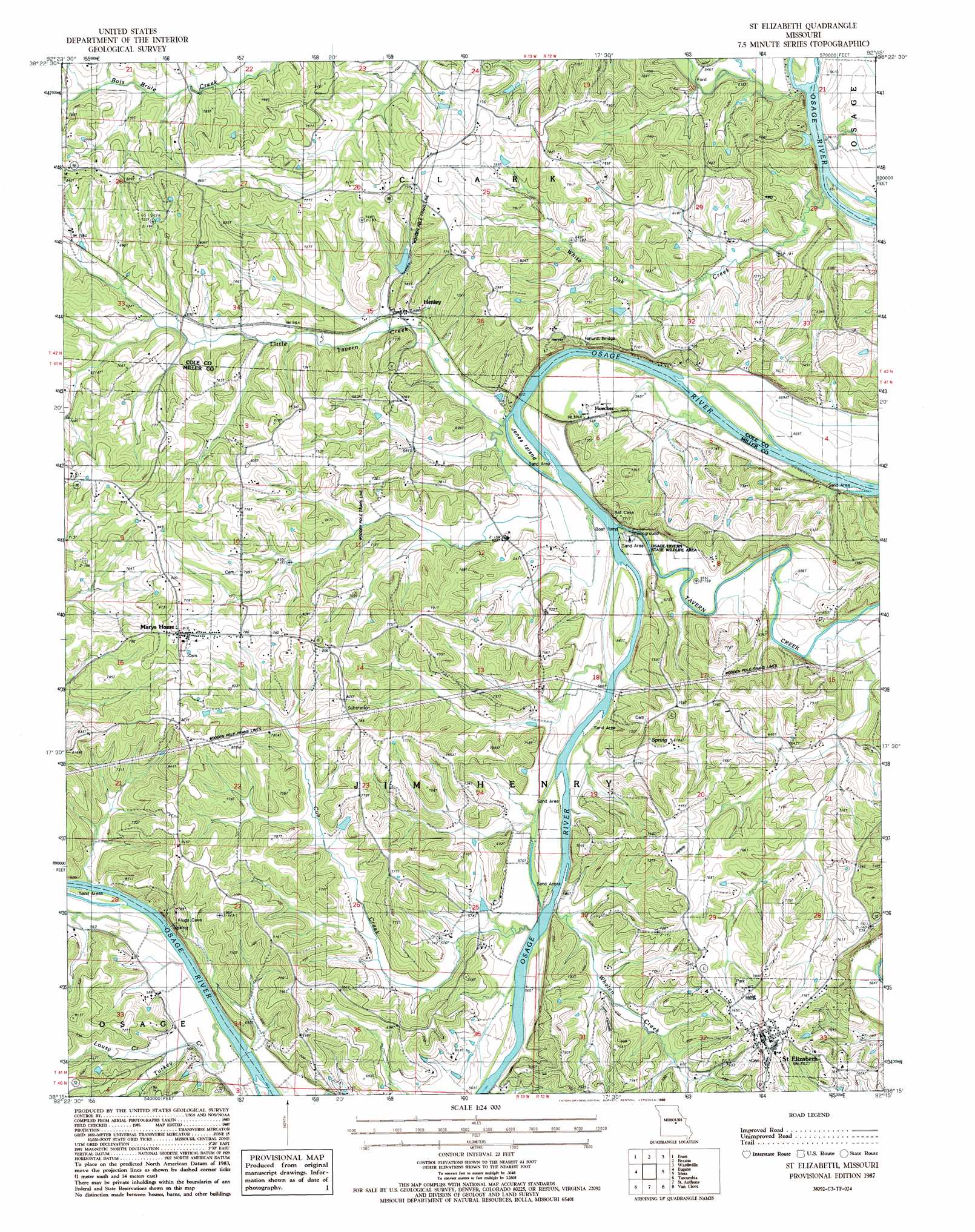
USGS Topo Quad 38092c3 - 1:24,000 scale
| Topo Map Name: | Saint Elizabeth |
| USGS Topo Quad ID: | 38092c3 |
| Print Size: | ca. 21 1/4" wide x 27" high |
| Southeast Coordinates: | 38.25° N latitude / 92.25° W longitude |
| Map Center Coordinates: | 38.3125° N latitude / 92.3125° W longitude |
| U.S. State: | MO |
| Filename: | o38092c3.jpg |
| Download Map JPG Image: | Saint Elizabeth topo map 1:24,000 scale |
| Map Type: | Topographic |
| Topo Series: | 7.5´ |
| Map Scale: | 1:24,000 |
| Source of Map Images: | United States Geological Survey (USGS) |
| Alternate Map Versions: |
St. Elizabeth MO 1987, updated 1988 Download PDF Buy paper map Saint Elizabeth MO 2011 Download PDF Buy paper map Saint Elizabeth MO 2015 Download PDF Buy paper map |
1:24,000 Topo Quads surrounding Saint Elizabeth
California South |
Russellville |
Lohman |
Jefferson City |
Osage City |
Olean |
Enon |
Brazito |
Wardsville |
Westphalia West |
Eldon |
Eugene |
Saint Elizabeth |
Meta |
Argyle |
Bagnell |
Tuscumbia |
Saint Anthony |
Van Cleve |
Brinktown |
Toronto |
Brumley |
Iberia |
Brays |
Big Bend |
> Back to 38092a1 at 1:100,000 scale
> Back to 38092a1 at 1:250,000 scale
> Back to U.S. Topo Maps home
Saint Elizabeth topo map: Gazetteer
Saint Elizabeth: Dams
Henley Lake Dam elevation 192m 629′Saint Elizabeth: Islands
Jones Island elevation 165m 541′Saint Elizabeth: Parks
Osage-Tavern State Wildlife Area elevation 171m 561′Saint Elizabeth: Populated Places
Henley elevation 181m 593′Hoecker elevation 184m 603′
Marys Home elevation 241m 790′
Saint Elizabeth elevation 249m 816′
Saint Elizabeth: Reservoirs
Henley Lake elevation 192m 629′Saint Elizabeth: Streams
Bois Brule Creek elevation 175m 574′Cub Creek elevation 170m 557′
Little Tavern Creek elevation 169m 554′
Lousy Creek elevation 169m 554′
Tavern Creek elevation 167m 547′
Turkey Creek elevation 177m 580′
Whalen Creek elevation 165m 541′
White Oak Creek elevation 168m 551′
Saint Elizabeth digital topo map on disk
Buy this Saint Elizabeth topo map showing relief, roads, GPS coordinates and other geographical features, as a high-resolution digital map file on DVD: