Mount Big Chief Topo Map Colorado
To zoom in, hover over the map of Mount Big Chief
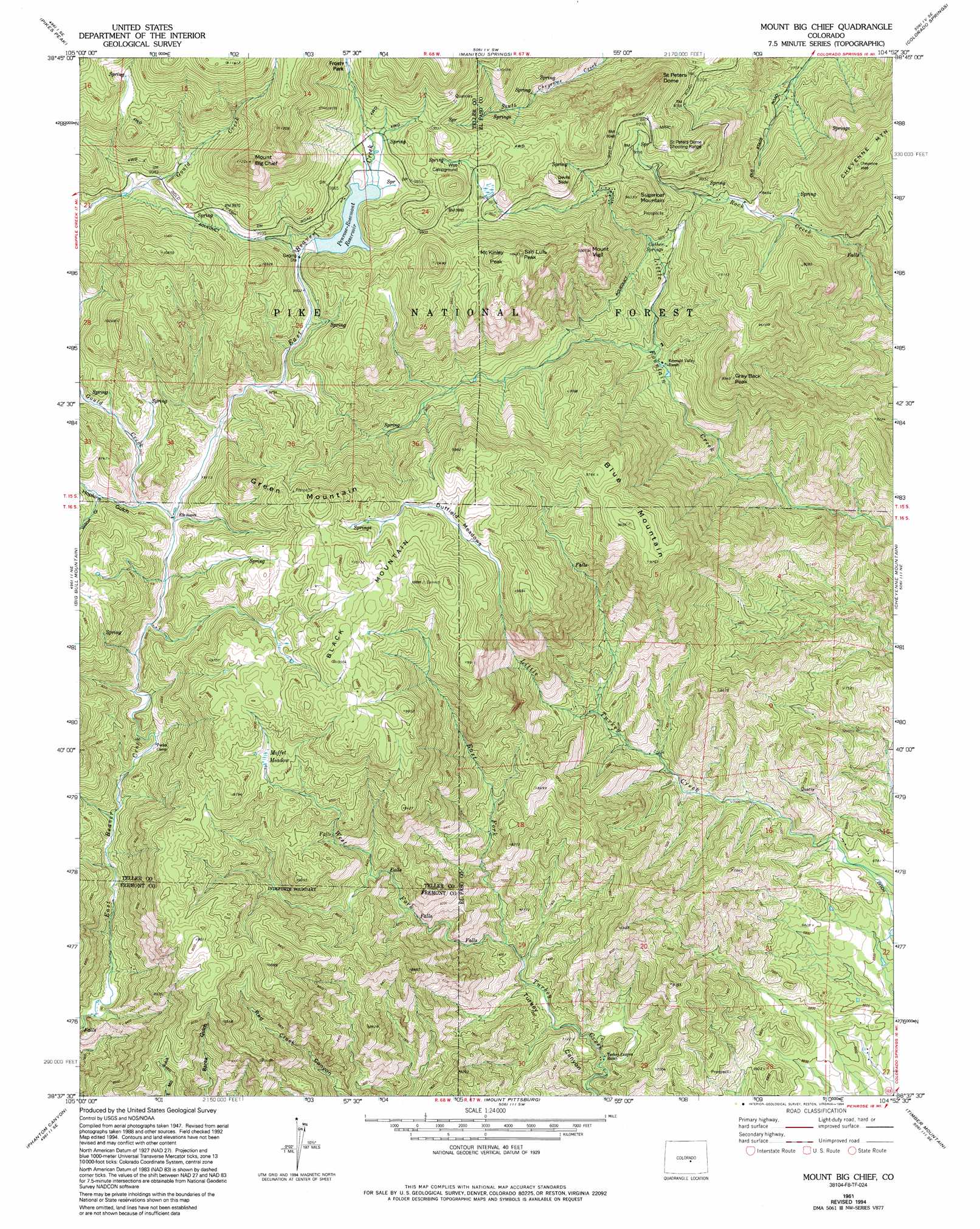
USGS Topo Quad 38104f8 - 1:24,000 scale
| Topo Map Name: | Mount Big Chief |
| USGS Topo Quad ID: | 38104f8 |
| Print Size: | ca. 21 1/4" wide x 27" high |
| Southeast Coordinates: | 38.625° N latitude / 104.875° W longitude |
| Map Center Coordinates: | 38.6875° N latitude / 104.9375° W longitude |
| U.S. State: | CO |
| Filename: | o38104f8.jpg |
| Download Map JPG Image: | Mount Big Chief topo map 1:24,000 scale |
| Map Type: | Topographic |
| Topo Series: | 7.5´ |
| Map Scale: | 1:24,000 |
| Source of Map Images: | United States Geological Survey (USGS) |
| Alternate Map Versions: |
Mount Big Chief CO 1948, updated 1953 Download PDF Buy paper map Mount Big Chief CO 1949 Download PDF Buy paper map Mount Big Chief CO 1961, updated 1963 Download PDF Buy paper map Mount Big Chief CO 1961, updated 1970 Download PDF Buy paper map Mount Big Chief CO 1961, updated 1970 Download PDF Buy paper map Mount Big Chief CO 1961, updated 1978 Download PDF Buy paper map Mount Big Chief CO 1961, updated 1978 Download PDF Buy paper map Mount Big Chief CO 1961, updated 1994 Download PDF Buy paper map Mount Big Chief CO 1994, updated 1998 Download PDF Buy paper map Mount Big Chief CO 2011 Download PDF Buy paper map Mount Big Chief CO 2013 Download PDF Buy paper map Mount Big Chief CO 2016 Download PDF Buy paper map |
| FStopo: | US Forest Service topo Mount Big Chief is available: Download FStopo PDF Download FStopo TIF |
1:24,000 Topo Quads surrounding Mount Big Chief
Divide |
Woodland Park |
Cascade |
Pikeview |
Falcon Nw |
Cripple Creek North |
Pikes Peak |
Manitou Springs |
Colorado Springs |
Elsmere |
Cripple Creek South |
Big Bull Mountain |
Mount Big Chief |
Cheyenne Mountain |
Fountain |
Cooper Mountain |
Phantom Canyon |
Mount Pittsburg |
Timber Mountain |
Buttes |
Canon City |
Florence |
Pierce Gulch |
Stone City |
Steele Hollow |
> Back to 38104e1 at 1:100,000 scale
> Back to 38104a1 at 1:250,000 scale
> Back to U.S. Topo Maps home
Mount Big Chief topo map: Gazetteer
Mount Big Chief: Cliffs
Devils Slide elevation 2994m 9822′Mount Big Chief: Dams
Glen Cairn Dam elevation 2017m 6617′Penrose-Rosemont Dam elevation 2949m 9675′
Mount Big Chief: Flats
Duffield Meadows elevation 2888m 9475′Mount Big Chief: Mines
Comanche Group Mine elevation 3093m 10147′Heavy Stone Lode elevation 3075m 10088′
Saint Peters Dome Mine elevation 2630m 8628′
Timberline Mine elevation 3128m 10262′
Winfield Scott Stratton Mine elevation 2797m 9176′
Mount Big Chief: Populated Places
Duffield elevation 2829m 9281′Rosemont elevation 2994m 9822′
Mount Big Chief: Reservoirs
Glen Cairn Reservoir elevation 2017m 6617′Penrose-Rosemont Reservoir elevation 2949m 9675′
Penrose-Rosemont Reservoir elevation 2941m 9648′
Mount Big Chief: Springs
Cather Springs elevation 2596m 8517′Mount Big Chief: Streams
East Fork Turkey Creek elevation 2186m 7171′Gould Creek elevation 2754m 9035′
West Fork Turkey Creek elevation 2186m 7171′
Mount Big Chief: Summits
Black Mountain elevation 3089m 10134′Blue Mountain elevation 2999m 9839′
Cheyenne Mountain elevation 2915m 9563′
Gray Back Peak elevation 2847m 9340′
Green Mountain elevation 3084m 10118′
Knights Peak elevation 3188m 10459′
McKinley Peak elevation 3180m 10433′
Mount Big Chief elevation 3404m 11167′
Mount Vigil elevation 3055m 10022′
Saint Peters Dome elevation 2943m 9655′
San Luis Peak elevation 3174m 10413′
Sugarloaf Mountain elevation 2934m 9625′
Mount Big Chief: Swamps
Moffet Meadow elevation 2870m 9416′Mount Big Chief: Valleys
Hopkins Gulch elevation 2756m 9041′Willow Gulch elevation 2812m 9225′
Mount Big Chief digital topo map on disk
Buy this Mount Big Chief topo map showing relief, roads, GPS coordinates and other geographical features, as a high-resolution digital map file on DVD: