Beckwith Mountain Topo Map Colorado
To zoom in, hover over the map of Beckwith Mountain
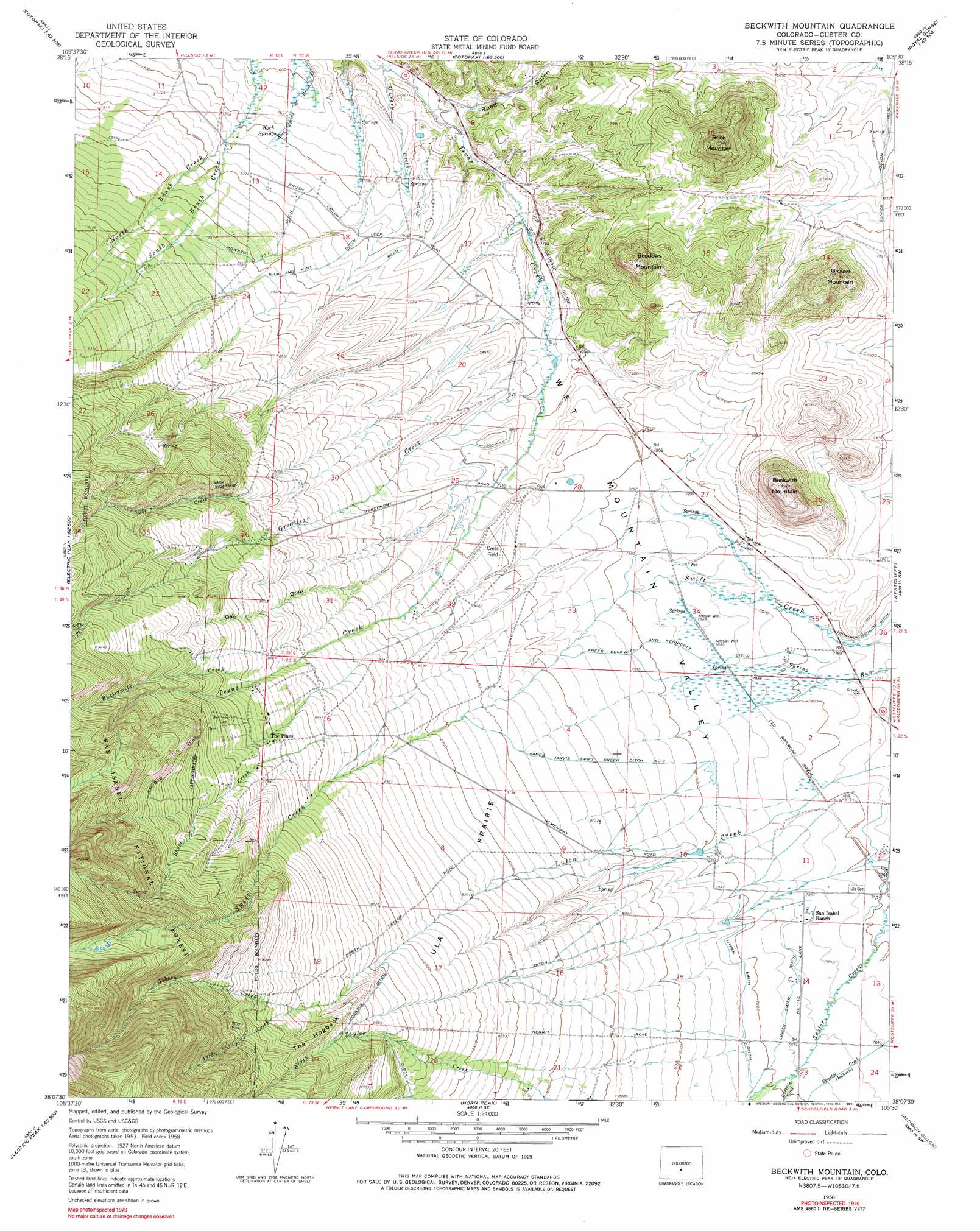
USGS Topo Quad 38105b5 - 1:24,000 scale
| Topo Map Name: | Beckwith Mountain |
| USGS Topo Quad ID: | 38105b5 |
| Print Size: | ca. 21 1/4" wide x 27" high |
| Southeast Coordinates: | 38.125° N latitude / 105.5° W longitude |
| Map Center Coordinates: | 38.1875° N latitude / 105.5625° W longitude |
| U.S. State: | CO |
| Filename: | o38105b5.jpg |
| Download Map JPG Image: | Beckwith Mountain topo map 1:24,000 scale |
| Map Type: | Topographic |
| Topo Series: | 7.5´ |
| Map Scale: | 1:24,000 |
| Source of Map Images: | United States Geological Survey (USGS) |
| Alternate Map Versions: |
Beckwith Mountain CO 1958, updated 1960 Download PDF Buy paper map Beckwith Mountain CO 1958, updated 1960 Download PDF Buy paper map Beckwith Mountain CO 1958, updated 1965 Download PDF Buy paper map Beckwith Mountain CO 1958, updated 1965 Download PDF Buy paper map Beckwith Mountain CO 1958, updated 1975 Download PDF Buy paper map Beckwith Mountain CO 1958, updated 1990 Download PDF Buy paper map Beckwith Mountain CO 1958, updated 1990 Download PDF Buy paper map Beckwith Mountain CO 2001, updated 2005 Download PDF Buy paper map Beckwith Mountain CO 2011 Download PDF Buy paper map Beckwith Mountain CO 2013 Download PDF Buy paper map Beckwith Mountain CO 2016 Download PDF Buy paper map |
| FStopo: | US Forest Service topo Beckwith Mountain is available: Download FStopo PDF Download FStopo TIF |
1:24,000 Topo Quads surrounding Beckwith Mountain
Howard |
Arkansas Mountain |
Echo |
Mcintyre Hills |
Royal Gorge |
Coaldale |
Cotopaxi |
Hillside |
Iron Mountain |
Curley Peak |
Valley View Hot Springs |
Electric Peak |
Beckwith Mountain |
Westcliffe |
Mount Tyndall |
Mirage |
Rito Alto Peak |
Horn Peak |
Aldrich Gulch |
Rosita |
Sheds Camp |
Crestone |
Crestone Peak |
Beck Mountain |
Devils Gulch |
> Back to 38105a1 at 1:100,000 scale
> Back to 38104a1 at 1:250,000 scale
> Back to U.S. Topo Maps home
Beckwith Mountain topo map: Gazetteer
Beckwith Mountain: Airports
Cress Field elevation 2448m 8031′Beckwith Mountain: Areas
Ula Prairie elevation 2532m 8307′Beckwith Mountain: Canals
Freer-Beckwith and Kennicott Ditch elevation 2397m 7864′Hogback Ditch elevation 2646m 8681′
Howard Number 1 Ditch elevation 2391m 7844′
James Jarvis Swift Creek Ditch Number 3 elevation 2439m 8001′
Kick and Kint Ditch elevation 2395m 7857′
Lohstroh Highline Ditch elevation 2369m 7772′
Lower Smith Ditch elevation 2396m 7860′
Reed Ditch elevation 2391m 7844′
Ula Ditch elevation 2547m 8356′
Upper Smith Ditch elevation 2408m 7900′
Beckwith Mountain: Mines
Phares and Allen Mine elevation 2473m 8113′Beckwith Mountain: Populated Places
Ula (historical) elevation 2378m 7801′Beckwith Mountain: Ridges
The Hogback elevation 2688m 8818′Beckwith Mountain: Springs
Koch Springs elevation 2353m 7719′Beckwith Mountain: Streams
Buttermilk Creek elevation 2612m 8569′Gibson Creek elevation 2706m 8877′
Goat Creek elevation 2349m 7706′
Goodwin Creek elevation 2405m 7890′
Greenleaf Creek elevation 2374m 7788′
North Brush Creek elevation 2358m 7736′
North Greenleaf Creek elevation 2800m 9186′
O'Leary Creek elevation 2300m 7545′
Short Creek elevation 2407m 7896′
South Brush Creek elevation 2358m 7736′
South Greenleaf Creek elevation 2800m 9186′
Verde Creek elevation 2706m 8877′
Beckwith Mountain: Summits
Beckwith Mountain elevation 2606m 8549′Beddows Mountain elevation 2590m 8497′
Buck Mountain elevation 2631m 8631′
Grouse Mountain elevation 2573m 8441′
Beckwith Mountain: Valleys
Oak Draw elevation 2485m 8152′Reed Gulch elevation 2323m 7621′
Beckwith Mountain digital topo map on disk
Buy this Beckwith Mountain topo map showing relief, roads, GPS coordinates and other geographical features, as a high-resolution digital map file on DVD: