Bull Canyon Topo Map Colorado
To zoom in, hover over the map of Bull Canyon
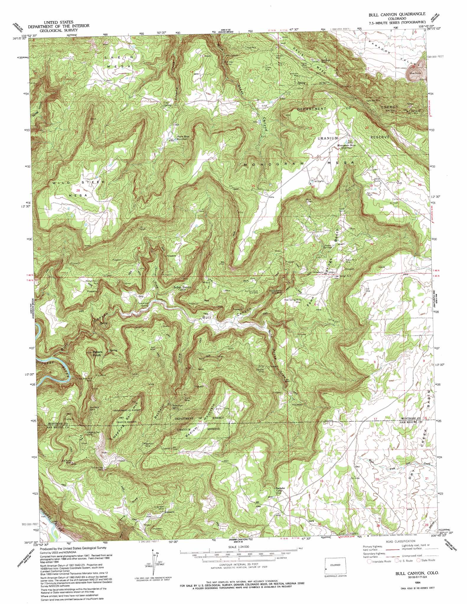
USGS Topo Quad 38108b7 - 1:24,000 scale
| Topo Map Name: | Bull Canyon |
| USGS Topo Quad ID: | 38108b7 |
| Print Size: | ca. 21 1/4" wide x 27" high |
| Southeast Coordinates: | 38.125° N latitude / 108.75° W longitude |
| Map Center Coordinates: | 38.1875° N latitude / 108.8125° W longitude |
| U.S. State: | CO |
| Filename: | o38108b7.jpg |
| Download Map JPG Image: | Bull Canyon topo map 1:24,000 scale |
| Map Type: | Topographic |
| Topo Series: | 7.5´ |
| Map Scale: | 1:24,000 |
| Source of Map Images: | United States Geological Survey (USGS) |
| Alternate Map Versions: |
Bull Canyon CO 1948, updated 1955 Download PDF Buy paper map Bull Canyon CO 1949 Download PDF Buy paper map Bull Canyon CO 1949 Download PDF Buy paper map Bull Canyon CO 1960, updated 1961 Download PDF Buy paper map Bull Canyon CO 1960, updated 1961 Download PDF Buy paper map Bull Canyon CO 1960, updated 1980 Download PDF Buy paper map Bull Canyon CO 1960, updated 1986 Download PDF Buy paper map Bull Canyon CO 1994, updated 1994 Download PDF Buy paper map Bull Canyon CO 2011 Download PDF Buy paper map Bull Canyon CO 2013 Download PDF Buy paper map Bull Canyon CO 2016 Download PDF Buy paper map |
1:24,000 Topo Quads surrounding Bull Canyon
Buckeye Reservoir |
Roc Creek |
Red Canyon |
Atkinson Creek |
Windy Point |
Wray Mesa |
Paradox |
Davis Mesa |
Uravan |
Nucla |
Lisbon Gap |
Anderson Mesa |
Bull Canyon |
Naturita Nw |
Naturita |
Summit Point |
Horse Range Mesa |
Hamm Canyon |
Gypsum Gap |
Basin |
Piute Point |
Egnar |
Joe Davis Hill |
Dawson Draw |
Mckenna Peak |
> Back to 38108a1 at 1:100,000 scale
> Back to 38108a1 at 1:250,000 scale
> Back to U.S. Topo Maps home
Bull Canyon topo map: Gazetteer
Bull Canyon: Benches
Fawn Springs Bench elevation 1903m 6243′Bull Canyon: Mines
Alke Mine elevation 2010m 6594′April Mine elevation 1936m 6351′
April Number One Mine elevation 1873m 6145′
Arcturus Mine elevation 1976m 6482′
Aztec Mine elevation 1993m 6538′
Babe Ruth Mine elevation 1927m 6322′
Bachelor Mine elevation 2065m 6774′
Big Bull Mine elevation 1862m 6108′
Black Diamond Mine elevation 1954m 6410′
Blue Moon Mine elevation 1993m 6538′
Bob Number Eight Mine elevation 2004m 6574′
Bob Number Seven Mine elevation 2005m 6578′
Bob Number Six Mine elevation 2004m 6574′
Bobtail Mine elevation 1950m 6397′
Broker Mine elevation 1996m 6548′
Burro Point Mine elevation 2000m 6561′
Burro Point Mine elevation 2160m 7086′
Calvert Mine elevation 1933m 6341′
Camel Number Six Mine elevation 1873m 6145′
Camoose Mine elevation 1873m 6145′
Canopus Mine elevation 1988m 6522′
Capella Mine elevation 1961m 6433′
Captain Jack Group Mine elevation 2135m 7004′
Chipmunk Mine elevation 2000m 6561′
Dads Mine elevation 1871m 6138′
Diana Mine elevation 1942m 6371′
Dinah Number Two Mine elevation 1873m 6145′
Doagy Mine elevation 2005m 6578′
Dorothy Jean Mine elevation 1950m 6397′
Dorothy Jean Number Two Mine elevation 1950m 6397′
East Opera Box Mine elevation 2005m 6578′
Echo Mine elevation 1795m 5889′
Echo Number Four Mine elevation 1795m 5889′
Edna Mae Mine elevation 1953m 6407′
Edna Mae Mine elevation 1965m 6446′
Egbert Mine elevation 1881m 6171′
Fawn Springs Mine elevation 1907m 6256′
Fawn Springs Number 5 Mine elevation 1899m 6230′
Fawn Springs Number 9 Mine elevation 1911m 6269′
Fawn Springs Number Eighteen Mine elevation 1944m 6377′
Fawn Springs Number Eleven Mine elevation 1905m 6250′
Fawn Springs Number Fifteen Mine elevation 1906m 6253′
Fawn Springs Number Five Mine elevation 1899m 6230′
Fawn Springs Number Four Mine elevation 1898m 6227′
Fawn Springs Number Seven Mine elevation 1905m 6250′
Fawn Springs Number Thirteen Mine elevation 1907m 6256′
Fawn Springs Number Thirty Mine elevation 1913m 6276′
Fawn Springs Number Twelve Mine elevation 1950m 6397′
Fawn Springs Number Twenty-nine Mine elevation 2005m 6578′
Fawn Springs Number Twenty-one Mine elevation 1913m 6276′
Fawn Springs Number Two Mine elevation 1913m 6276′
Giant Mine elevation 2106m 6909′
Goodenough Number One Mine elevation 2048m 6719′
Goodenough Number Three Mine elevation 2048m 6719′
Goodenough Number Two Mine elevation 2048m 6719′
Gopher Mine elevation 1965m 6446′
Grandad Number Two Mine elevation 1894m 6213′
Gray Point Mine elevation 2134m 7001′
Great Expectation Tunnel Mine elevation 2103m 6899′
Great Hesper Mine elevation 1950m 6397′
Ground Hog Mine elevation 2088m 6850′
Ground Hog Mine elevation 1977m 6486′
Ground Hog Number Four Mine elevation 2078m 6817′
Gypsum Valley Number Three Mine elevation 2153m 7063′
High Ball Five Mine elevation 1988m 6522′
High Ball Mine elevation 1873m 6145′
Hobo Mine elevation 1873m 6145′
Horsehair Mine elevation 1873m 6145′
Hot Shot Mine elevation 2160m 7086′
Hot Shot Mine elevation 2001m 6564′
Insert Mine elevation 2081m 6827′
Iola Mine elevation 1878m 6161′
Jack Knife Mine elevation 1977m 6486′
Jack Knife Mine elevation 2052m 6732′
Jack Knife Three Mine elevation 2001m 6564′
Jackknife Number Two Mine elevation 2001m 6564′
Joe Dandy Mine elevation 1963m 6440′
John K Mine elevation 2111m 6925′
Lark Number One Mine elevation 1986m 6515′
Lark Number Seven Mine elevation 1920m 6299′
Last Chance Mine elevation 1786m 5859′
Log Cabin Mine elevation 1921m 6302′
Lohi Mine elevation 1734m 5688′
Long Park Incline Mine elevation 1873m 6145′
Lost Brothers Mine elevation 2007m 6584′
Lucky Boy Mine elevation 2102m 6896′
Lucky Day Mine elevation 1840m 6036′
Main Street Mine Number Three elevation 1983m 6505′
Main Street Mine Number Two elevation 1983m 6505′
Mainstreet Mine elevation 1983m 6505′
Mary Ann Mine elevation 1989m 6525′
Mary Ann Number Four Mine elevation 2016m 6614′
Mary Jane Mine elevation 1967m 6453′
Mary Number Four Mine elevation 1950m 6397′
McKee Group Mine elevation 2031m 6663′
Mesa Mine elevation 1873m 6145′
Mitchell and Cucher Group Mine elevation 2172m 7125′
Monogram Mines elevation 1987m 6519′
Morning Mine elevation 1873m 6145′
Morning Mine elevation 1786m 5859′
Navajo Mine elevation 2099m 6886′
New Camp Bird Mine elevation 2021m 6630′
Nil Number One Mine elevation 2036m 6679′
Nil Number Two Mine elevation 2012m 6601′
North Hummer Mine elevation 1958m 6423′
North Side Mines elevation 1824m 5984′
North Standard Mine elevation 1873m 6145′
Nucla Mine elevation 1765m 5790′
Obnoxious Mine elevation 1919m 6295′
Occidental Mine elevation 1870m 6135′
Old Grandad Mine elevation 1894m 6213′
Old Grandad Mine elevation 2061m 6761′
Old Quaker Mine elevation 2065m 6774′
Opera Box Mine elevation 1969m 6459′
Oversite Mine elevation 1973m 6473′
Paddy Number Four Mine elevation 1921m 6302′
Patty Four Mine elevation 1922m 6305′
Patty Number Five Mine elevation 1862m 6108′
Peanut East Central Mine elevation 2004m 6574′
Peanut Group 28-35 Mines elevation 1919m 6295′
Peanut Group Mine elevation 1877m 6158′
Peanut Incline Number Five Mine elevation 2004m 6574′
Peanut Mine elevation 2004m 6574′
Peanut Number 3 Mine elevation 1923m 6309′
Peanut Number Four Mine elevation 2004m 6574′
Peanut Number Twenty-four Mine elevation 2004m 6574′
Peggy Mine elevation 2036m 6679′
Picket Corral Number Four Mine elevation 1921m 6302′
Pickett Corral Number Two Mine elevation 1921m 6302′
Piñon Mine elevation 1687m 5534′
Pluto Mine elevation 1941m 6368′
Quarrel Group Mine elevation 1853m 6079′
Rabbit Foot Two Mine elevation 1831m 6007′
Radium Hill Group Mine elevation 1896m 6220′
Radium Hill Number Fifty Mine elevation 2012m 6601′
Radium Hill Number Seven Mine elevation 2047m 6715′
Radium Hill Number Thirty-one Mine elevation 2047m 6715′
Radium Hill Number Twelve Mine elevation 2047m 6715′
Radium Hill Number Twenty-two Mine elevation 2047m 6715′
Radium Hills Mine elevation 2047m 6715′
Rattlesnake Number Two Mine elevation 1891m 6204′
Red Flag Incline Mine elevation 1809m 5935′
Red Flash Mine elevation 1873m 6145′
Red Flat Number Six Mine elevation 1873m 6145′
Rim Rock Blues Group Mine elevation 1905m 6250′
Rim Rock Blues Number Five Mine elevation 1908m 6259′
Rim Rock Blues Number Four Mine elevation 1908m 6259′
Rim Rock Blues Number Fourteen Mine elevation 1908m 6259′
Rim Rock Blues Number Nine Mine elevation 1908m 6259′
Rim Rock Blues Number Seven Mine elevation 1901m 6236′
Rim Rock Blues Number Seventeen Mine elevation 1883m 6177′
Rim Rock Blues Number Six East Mine elevation 1860m 6102′
Rim Rock Blues Number Sixteen Mine elevation 1908m 6259′
Rim Rock Blues Number Three Mine elevation 1908m 6259′
Rim Rock Blues Number Twelve Mine elevation 1908m 6259′
Rim Rock Blues Number Two Mine elevation 1915m 6282′
Rim Rock Blues Number Two North Mine elevation 1908m 6259′
Rim Rock Mine elevation 1994m 6541′
Rim Rock Number 3 Mine elevation 1885m 6184′
Rim Rock Number Fourteen Mine elevation 2017m 6617′
Rim Rock Number Nine Mine elevation 2017m 6617′
Rim Rock Number Seventeen Mine elevation 2017m 6617′
Rim Rock Number Six Mine elevation 2017m 6617′
Rim Rock Number Sixteen Mine elevation 2017m 6617′
Rim Rock Number Twelve Mine elevation 2017m 6617′
Rim Rock Number Two Mine elevation 1967m 6453′
Rim Rocks Blues Number 6 Mine elevation 1902m 6240′
Rimrock Group Mine elevation 1959m 6427′
Royal Oak Mine elevation 1980m 6496′
Sam Mine elevation 1839m 6033′
San Pedro Mine elevation 1880m 6167′
School Marm Mine elevation 1897m 6223′
September Morn Number One Mine elevation 1890m 6200′
September Morn Number Two Mine elevation 1890m 6200′
September Morning Mine elevation 1899m 6230′
Sirius Mine elevation 1978m 6489′
Slick Rim Mine elevation 2013m 6604′
Solitaire and Jack Pot Claims Group Mine elevation 1935m 6348′
South Happy Thought Mine elevation 1798m 5898′
South Peanut Mine elevation 2004m 6574′
Starlight Mine elevation 1855m 6085′
Starlight Number 7 Mine elevation 1826m 5990′
Starlight Number Eight Mine elevation 1844m 6049′
Starlight Number Four Mine elevation 1844m 6049′
Starlight Number One Mine elevation 1844m 6049′
Starlight Number Two Mine elevation 1844m 6049′
Steer Mine elevation 2133m 6998′
Sunny Side Lode Mine elevation 1969m 6459′
Sunnyside Mine elevation 2003m 6571′
Sunrise Mine elevation 1741m 5711′
Sunrise Mine elevation 1921m 6302′
Sunrise Number Five Mine elevation 1741m 5711′
Sunrise Number Four Mine elevation 2015m 6610′
Sunrise Number Two Mine elevation 1741m 5711′
Susquehanna Mine elevation 1726m 5662′
Tango Mine elevation 1990m 6528′
Teapot Dome Mine elevation 1895m 6217′
Teapot Dome Number 2 Mine elevation 1898m 6227′
Teapot Dome Three Mine elevation 1895m 6217′
Townsite Mine elevation 1896m 6220′
Two Bits Mine elevation 1926m 6318′
Ura Mine elevation 2142m 7027′
Uranus Mine elevation 2008m 6587′
Vaden View Mine elevation 1847m 6059′
Valley View Mine elevation 2120m 6955′
Venture Lodge Mine elevation 1910m 6266′
Venture Mine elevation 1793m 5882′
Vernita Mine elevation 2026m 6646′
Wedding Bell Mine elevation 2018m 6620′
West End Mine elevation 2016m 6614′
West Opera Box Mine elevation 2018m 6620′
Whang Doodle Mine elevation 1839m 6033′
Wild Steer Mines elevation 1837m 6026′
Wilson Mine elevation 2011m 6597′
Woodward Mine elevation 1769m 5803′
Yellow Bird Mine elevation 2144m 7034′
Zebra Mine elevation 1920m 6299′
Bull Canyon: Reservoirs
Monogram Mesa Reservoir elevation 2107m 6912′Skein Mesa Reservoir elevation 1939m 6361′
Bull Canyon: Springs
Calf Spring elevation 1936m 6351′Cummings Spring elevation 1717m 5633′
Fawn Springs elevation 1886m 6187′
Bull Canyon: Summits
Monogram Mesa elevation 2184m 7165′Peters Knob elevation 1861m 6105′
Radium Mountain elevation 2171m 7122′
Wedding Bell Mountain elevation 2185m 7168′
Wild Steer Mesa elevation 2150m 7053′
Bull Canyon: Valleys
Bachelor Draw elevation 1743m 5718′Bull Canyon elevation 1609m 5278′
Corral Draw elevation 1720m 5643′
Wild Horse Draw elevation 1764m 5787′
Bull Canyon digital topo map on disk
Buy this Bull Canyon topo map showing relief, roads, GPS coordinates and other geographical features, as a high-resolution digital map file on DVD: