Whitewater Topo Map Colorado
To zoom in, hover over the map of Whitewater
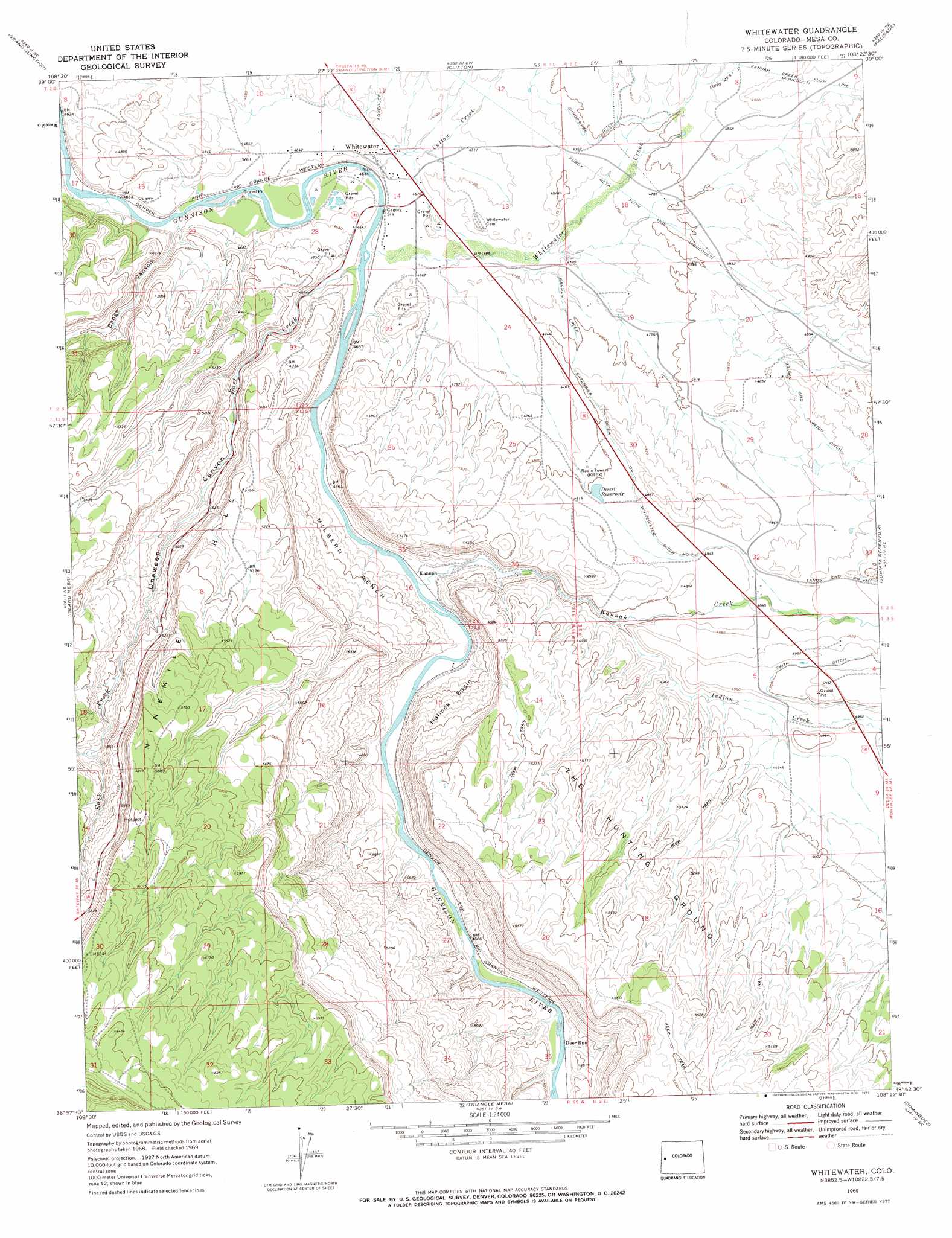
USGS Topo Quad 38108h4 - 1:24,000 scale
| Topo Map Name: | Whitewater |
| USGS Topo Quad ID: | 38108h4 |
| Print Size: | ca. 21 1/4" wide x 27" high |
| Southeast Coordinates: | 38.875° N latitude / 108.375° W longitude |
| Map Center Coordinates: | 38.9375° N latitude / 108.4375° W longitude |
| U.S. State: | CO |
| Filename: | o38108h4.jpg |
| Download Map JPG Image: | Whitewater topo map 1:24,000 scale |
| Map Type: | Topographic |
| Topo Series: | 7.5´ |
| Map Scale: | 1:24,000 |
| Source of Map Images: | United States Geological Survey (USGS) |
| Alternate Map Versions: |
Whitewater CO 1969, updated 1972 Download PDF Buy paper map Whitewater CO 1969, updated 1972 Download PDF Buy paper map Whitewater CO 2010 Download PDF Buy paper map Whitewater CO 2013 Download PDF Buy paper map Whitewater CO 2016 Download PDF Buy paper map |
1:24,000 Topo Quads surrounding Whitewater
Fruita |
Corcoran Point |
Round Mountain |
Cameo |
Mesa |
Colorado National Monument |
Grand Junction |
Clifton |
Palisade |
Lands End |
Glade Park |
Island Mesa |
Whitewater |
Juniata Reservoir |
Indian Point |
Snyder Flats |
Jacks Canyon |
Triangle Mesa |
Dominguez |
Point Creek |
Casto Reservoir |
Keith Creek |
Escalante Forks |
Good Point |
Roubideau |
> Back to 38108e1 at 1:100,000 scale
> Back to 38108a1 at 1:250,000 scale
> Back to U.S. Topo Maps home
Whitewater topo map: Gazetteer
Whitewater: Airports
Whitewater Heliport elevation 1856m 6089′Whitewater: Areas
The Hunting Ground elevation 1605m 5265′Whitewater: Basins
Hallock Basin elevation 1481m 4858′Whitewater: Benches
Milbern Bench elevation 1453m 4767′Whitewater: Canals
Brown and Campion Ditch elevation 1498m 4914′Kannah Creek Extension Ditch elevation 1476m 4842′
Shropshire Ditch elevation 1463m 4799′
Smith Ditch elevation 1523m 4996′
Whitewater: Populated Places
Kannah elevation 1420m 4658′Whitewater elevation 1420m 4658′
Whitewater: Reservoirs
Desert Reservoir elevation 1465m 4806′Whitewater: Streams
Callow Creek elevation 1415m 4642′East Creek elevation 1415m 4642′
Indian Creek elevation 1451m 4760′
Kannah Creek elevation 1418m 4652′
North East Creek elevation 1609m 5278′
Whitewater Creek elevation 1415m 4642′
Whitewater: Valleys
Bangs Canyon elevation 1411m 4629′Unaweep Canyon elevation 1431m 4694′
Whitewater digital topo map on disk
Buy this Whitewater topo map showing relief, roads, GPS coordinates and other geographical features, as a high-resolution digital map file on DVD: